


Morgan's Bluff Harbor
Andros Bahamas
Marinas near Morgan's Bluff Harbor
| Name | Reviews | Max LOA | VHF | Dock Depth | Gas / Diesel | Lift / Crane | Wifi | Amps |
|---|---|---|---|---|---|---|---|---|
| Morgan's Bluff Ocean Freight Shipping Service Dock | - | - | - | - | - | - | - | - |
| Morgan's Bluff Commercial Harbor Dock | - | 40.0' | - | - | - | - | - | - |
| Chub Cay Club Marina | 190.0' | 68 | Low 12.0' | - | - | 30, 50, 100 | ||
| Kamalame Cay Resort | - | - | - | - | - | - | - | - |
| Little Whale Cay Marina | - | 0.0' | - | Low 0.0 mHigh 0.0' | - | - | - | |
| Kamalame Cay Marina | - | - | - | - | - | - | - | - |
| Lyford Cay Club Marina | - | 235.0' | 16 | Low 10.0' | G$5.53/galD$4.99/gal | - | - | 30, 50, 100 |
| Flo's Conch Bar and Restaurant | - | - | - | - | - | - | - | - |
| Albany Marina | - | 300.0' | 74 | Low 16.0'High 0.0' | GYesDYes | - | - | 30, 50, 100, 200 |
| Andros Lighthouse Yacht Club and Marina | 110.0' | 16 | Low 6.0' | G$7.50/galD$7.35/gal | - | - | ||
| Chickcharnies Hotel & Restaurant | - | - | - | - | - | - | - | - |
| Sandyport Marina Village | - | - | - | - | - | - | - | - |
| Great Harbour Cay Marina | 0.0 m | - | Low 0.0 mHigh 0.0' | GYesDYes | - | - | - | |
| Great Harbour Cay Marina | - | - | - | - | - | - | - | - |
| The Pointe Marina | 160.0' | 16 | Low 12.0' | - | - | 50A 120/240V single phase, 100A 120/240V single phase, 100A 208 3-phase power |
Introduction:
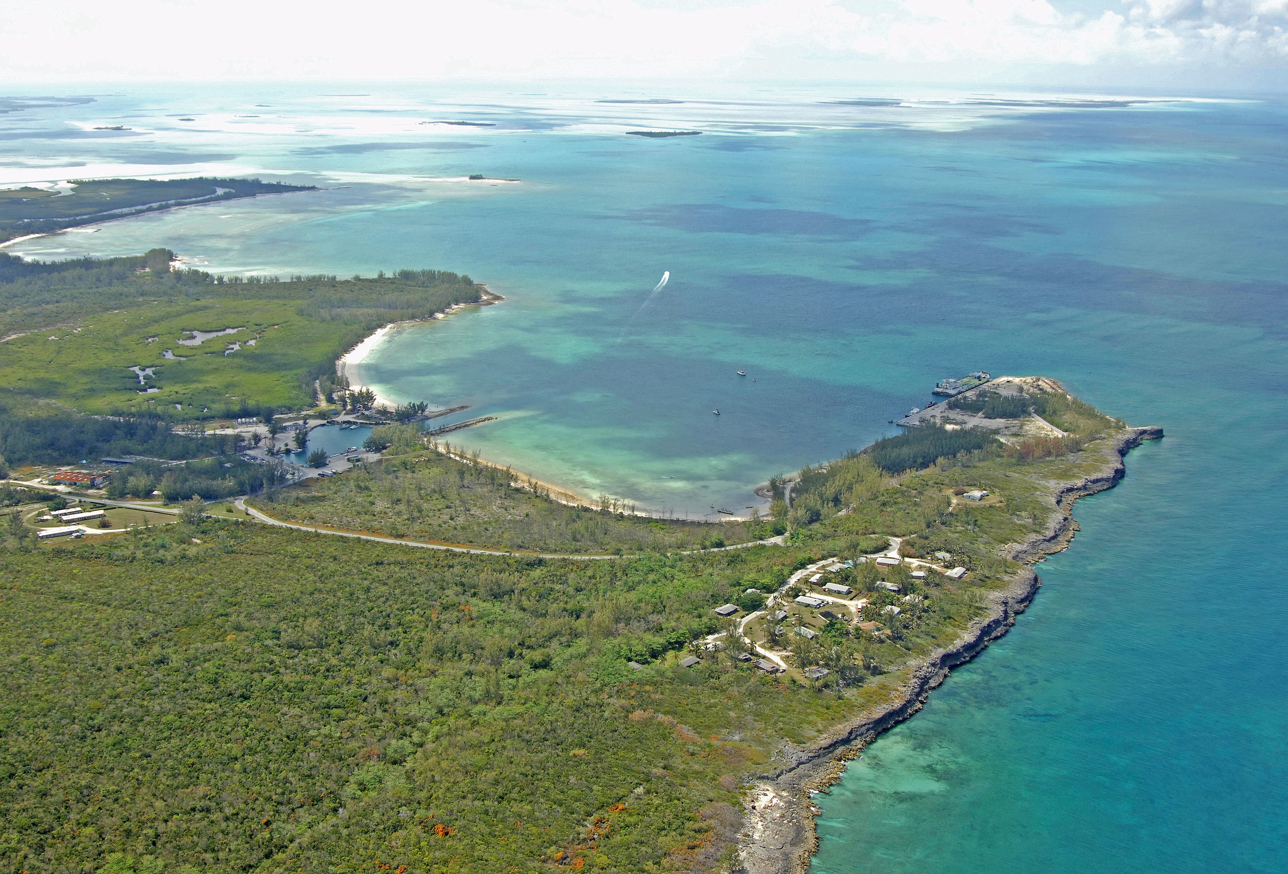
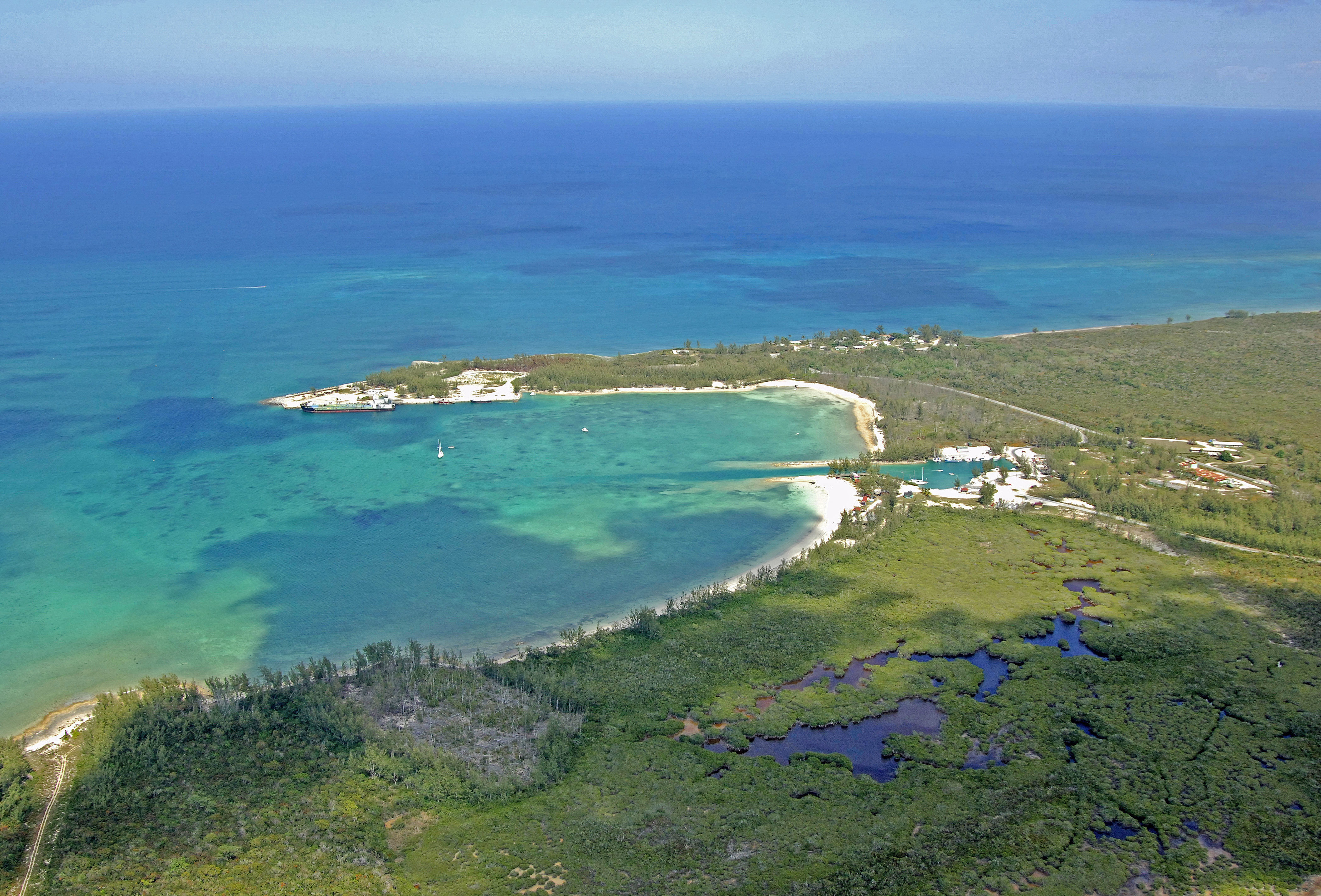
Morgans Bluff is often referred to as the last outpost of Andros, due to its extreme location on the very northeastern end of the island. Farther to the northeast are the neighboring Berry Islands. Though remote and lacking in facilities, Morgans Bluff has a well-protected bay for anchoring and a small commercial wharf at its southern end where you may be able to arrange for dockage. Many cruisers use the bay as a staging area when heading to points farther north.
Navigating the Water:
The beginning of the approach channel to Morgans Bluff is located at 25 11.257 N 78 00.885 W. Once you have picked up this point, you will notice the darker water that leads around Morgans Bluff and into the protected bay behind it to the west, but mind the channel markers once you proceed in.
Next, look for a a pair of flashing marks (one red and one green). From the green and red flashers, set a course of 239 degrees true for about eight-tenths of a mile until you spot the government dock on your port side (no tie ups allowed here). The channel is well marked all of the way in, and if you follow all the buoys, this should keep you out of trouble.
Just off the dock is an anchorage, which has six- to eight-foot depths over a sand bottom. Protection is poor during a norther, but Morganss Bluff affords good protection from most other directions.
Farther south is the Morgans Bluff Commercial Harbor Dock, which is mainly reserved for working vessels, but you may be able to arrange a tie up by radioing ahead of time. From the Government Dock at Morgans Bluff, steer a course of about 193 degrees true for about a half-mile, and then line up for the dredged opening. Depths in the channel are about six feet at low water.
Local Notices to Mariners:
See our Local Notices to Mariners blog for updates on the latest conditions and advisories for this area.
Things To Do/Local Events:
Andros is particularly famous for its bonefish fishery, which draw in fly-fishing anglers from around the world. Dozens of local guides can take you out onto the flats surrounding the island and provide a day of stalking elusive fish in a tropical setting.
For a detailed calendar of events, see our Helpful Links section below.