Pensacola Bay Inlet


About
Introduction:
The image above is a view from the south, looking north over the inlet from the Gulf of Mexico into Pensacola Bay with Fort Pickens on the right (east) and Fort McRee and Perdido Key on the left (west). Farther off in the distance is Naval Air Station Pensacola, where the U.S. Navys Flight Demonstration Team, the Blue Angels is headquartered.
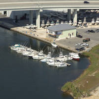
Most of the marina facilities in the area are located about an eight-mile journey to the northeast around Pickens Channel in Bayou Chico, west of the Pensacola waterfront. Many of the marinas here accept transient guests and a few have lifts for haul-out and repairs.
Navigating the Water:
Use NOAA Chart 11384.
The Pensacola Bay Inlet is one of the deepest and most reliable on the U.S. Gulf Coast, with an almost half-mile-wide entrance carrying 40- to seventy-foot depths along its length.
Flashing green gong buoy 1 and flashing red bell buoy 2 mark the beginning of the approach into Pensacola Bay about three miles south of the bays opening, though many boats choose to start their approach at flashing green gong buoy 5 and flashing red buoy 6.
From flashing green gong buoy 1 and flashing red bell buoy 2, set an approximate course of 343 degrees magnetic for about 3.2 miles, using the Caucus Channel Range to help guide you in. Along the way, you will pass flashing green buoy 3, flashing red buoy 4, flashing green buoy 5, flashing red buoy 6, green nun buoy 7, flashing red buoy 8, and then flashing green buoy 9, where you will intercept the Fort Barrancas Range and change course to the north.
Once you have picked up the Fort Barrancas Range, follow red nun buoy 10, green nun buoy 11, flashing red buoy 12, and then flashing red buoy 14 around the five-foot-deep shoals that reach out to the west from Fort Pickens. The rest of the journey in toward Pensacola is fairly uneventful with plentiful markers, deep water, and several ranges to aid both nighttime and daytime navigation.
Keep in mind that there is a security perimeter maintained around U.S. Navy vessels at all times, both while in port, and underway. While they are in port, simply steer clear and keep a safe distance away, while underway, keep as clear as possible, and keep tuned to VHF 16 in case you are hailed for being too close. Keeping as far away as safely possible is the best practice, however.
Local Notices to Mariners:
Local Notices to Mariners are available online from the U.S. Coast Guard.