Juba Creek Inlet
| Turks and Caicos Islands | |
| 21° 45' 29.88'', -72° 10' 21.0'' | |
| Southern Providenciales Island |
You might also consider...


About
Introduction:
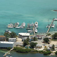
Juba Creek is located on Providenciales Islands South Shore about 5 miles southwest of Leeward Going Through and 3 miles east of Discovery Bay. The left entrance in the image above is officially Juba Point Creek, but is unnavigable. The cut into Caicos Marina and Shipyard is to the right, and is what we will discuss here.
The aforementioned Caicos Marina and Shipyard is the primary point of interest here, as it is the only facility in the Turks and Caicos that currently has equipment and facilities for haul-outs. Depths on the approach and in the cut are a reliable 7 to 8 feet, and only during a strong south blow do you need to be overly cautious about possible grounding.
Navigating the Water:
Juba Creek is approached via the south through Sapodilla Bay just west of Juba Point. On approach, simply set a course for the center of the opening into the Caicos Marina and Shipyard. There is a pair of markers at the entrance cut (red and green), but keeping to the middle of the cut will put you in the deepest water. Once you have cleared these markers, you will find 7- to 8-foot depths all the way back to the marina.
Local Notices to Mariners:
See our Local Notices to Mariners blog for updates on the latest conditions and advisories for this area.