Black River Inlet
| Jamestown Island, Virginia United States | |
| 37° 12' 56.88'', -76° 45' 42.13'' | |
| Sarah Creek |


You might also consider...


About
Introduction:
Back River is a secondary tributary that cuts behind Jamestown Island off of the James River in Virginia. The river actually separates a piece of land from the mainland, making it an island. Back River is a popular place for anchoring out and visiting Historic Jamestown Island. There is also a marina farther up on Powhatan Creek, but mariners should be advise that both the east and west entrances to Back River are fairly shoal, and that the east entrance is crossed by a 12-foot fixed vertical clearance bridge.
Navigating the Water:
Use NOAA Chart 12248.
If you approach Back River from the east off of the James River, your boat should be able to clear a 12-foot fixed vertical clearance and have a draft of less than three feet. The entrance at Church Point is convenient and offers a shorter access to Back River, but you obviously have to be able to clear it.
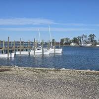
The preferred entrance (and the one pictured above) is via The Thorofare on the back side of Jamestown Island at Back Point. Keep in mind that this entrance is also shoal, but marked a little bit better than the bridge entrance to the west.
Local Notices to Mariners:
Local Notices to Mariners are available online from the U.S. Coast Guard.