Westecunk Creek Inlet
| West Creek, New Jersey United States | |
| 39° 36' 57.96'', -74° 15' 56.17'' | |
| Little Egg Harbor |


You might also consider...


About
Introduction:
Westecunk Creek is a small piece of side water that is located off Little Egg Harbor about three miles west of the town of Spray Beach. Located on the west side of Little Egg Harbor, Westecunk Creek is nine miles north of Little Egg Inlet and 14 miles south-southwest of Barnegat Inlet. Of the four marinas here, two accept transient guests, two have lifts for haul-outs and repair, but none of them have fuel available.
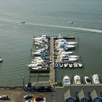
The image above is a view from the east looking west over the mouth of Westecunk Creek where it empties into Little Egg Harbor. The West Creek Marina can be seen just to the left (south) on entry, and is the closest marina on the creek to Little Egg Harbor that has transient slips. Farther up the creek, several more marinas (there are four in total) are visible lining the left (south) side of the creek.
Navigating the Water:
Use NOAA Chart 12316.
Westecunk Creek is reached via a side channel that breaks off the New Jersey ICW near Mile Marker 44. The approach to Westecunk Creek from the ICW has depths of three to four feet in places, so proceed accordingly in relation to your draft. There are private uncharted aids to navigation along the way.
First pick up quick flashing green 95 near waypoint N39 35.242 W74 13.991. Once you have safely navigated to quick flashing green 95, set an approximate course of 314 degrees magnetic for about 1.6 miles until you are in the area of flashing red 2, which is located on the tip of a small marsh island. Next, you will turn to the north on an approximate course of 19 degrees magnetic for about one mile until you are in sight of and lined up with the creek entrance.
Flashing green 3 marks the creek entrance, and a sharp eye can pick it up in the image above. Flashing green 3 is followed by flashing red 4, flashing green 5, and flashing red 6 near the head of the creek. The marinas are lined up along the south side of the creek and there are depths of four to six feet up until the last marina, where depths shoal quickly.
Local Notices to Mariners:
Local Notices to Mariners are available online from the U.S. Coast Guard.