Lewis Bay Inlet
| Hyannis, Massachusetts United States | |
| 41° 37' 49.07'', -70° 16' 21.0'' | |
| Hyannis Harbor |


You might also consider...

About
Introduction:
Lewis Bay is located on the south shore of Cape Cod just east of Hyannis Harbor and five miles west of South Yartmouth. The town of Hyannis is located on Lewis Bays northern end, and you will find three marinas and excellent opportunities for shopping and provisioning ashore. Of the three marinas in Hyannis, two of them accept transient guests and one selsl gas and diesel fuel in case you need to top off the tanks.
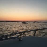
The image above is a view from the south looking north over the Lewis Bay entrance. To the left (west) is Dunbar Point, while the western point of Egg Island is visible in the right (east) portion of the image. Straight back from the inlet on the far shore near the water tower is the town of Hyannis. Off to the left behind Dunbar Point is a popular anchorage area that is protected from all directions except the east and northeast.
Navigating the Water:
Use NOAA Chart 13229.
Lewis Bay is approached from the southwest via Nantucket Sound and Hyannis Harbor. Although red and white Morse (A) buoy HH marks the official offshore entrance into Hyannis Harbor and Lewis Bay, most boaters navigate to waypoint N41 37.18 W70 17.47 and line up for the entry at flashing green buoy 5 and flashing red buoy 6. Once you have cleared flashing green buoy 5 and flashing red buoy 6, continue to the northeast to intercept green can buoy 7 and red nun buoy 8, and then farther on to flashing green buoy 9 and flashing red buoy 10 (the first set of visible buoys in the image above).
After you have cleared that set of buoys from Hyannis Harbor, set a course to pick up flashing green buoy 11 and red nun buoy 12 near Dunbar Point, and then run north to green can buoy 13 and flashing red buoy 14, just to the north.
There is an anchorage and mooring field available just behind Dunbar Point, or alternatively, if you have checked availability, you can head north to the town of Hyannis to tie up at one of the marinas for the night. Most of Lewis Bay is designated as an anchorage. Beside the area at Dunbar Point, check out another area in the northeast portion of the bay near West Yartmouth if the wind pipes up from the northeast.
Local Notices to Mariners:
Local Notices to Mariners are available online from the U.S. Coast Guard.