Discovery Bay Inlet
| Turks and Caicos Islands | |
| 21° 45' 20.88'', -72° 13' 10.93'' | |
| Northeast Providenciales Island |
You might also consider...


About
Introduction:
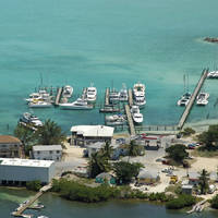
Although there are four man-made harbors that cut into the South Shore of Providenciales Island, only two of them contain marine facilities. The first (traveling east along Sapodillas Bay) is the South Side Basin Marina in Discovery Bay, which we will discuss here, and the second is farther east at Juba Point Creek, about 3 miles away.
Navigating the Water:
The South Side Basin Marina is located in Cooper Jack Bight, an area that is more commonly referred to as Discovery Bay. Discovery Bay is located off Sapodilla Bay in the southwest quadrant of Providenciales Island and is approached from the south via a locally marked passage east of Cooper Jack Rock (5-foot depths).
From Cooper Jack Point, set a course for the south edge of Cooper Jack Rock, and then turn toward the northeast and the center of the inlet into Discovery Bay. This is pretty much a feel your way in entrance, and most boaters sight their way in during the day.
Local Notices to Mariners:
See our Local Notices to Mariners blog for updates on the latest conditions and advisories for this area.