Tolomato River South Inlet
| Vilano Beach, Florida United States | |
| 29° 54' 34.2'', -81° 17' 56.03'' | |
| St. Augustine |


You might also consider...


About
Introduction:
The Tolomato River is located on Floridas East Coast just north of St. Augustine, where it meets the St. Augustine Inlet and the Matanzas River near Intracoastal Waterway (ICW) Mile 776.
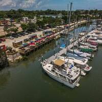
The image above is a view from the south looking north over the St. Augustine Inlet (right) toward the opening of the Tolomato River and the Usina Bridge (65-foot fixed vertical clearance). On the left side of the bridge is the expansive Camachee Cove complex, which has several well equipped marinas and repair facilities.
Navigating the Water:
Use NOAA Chart 11485.
Though the Tolomato River itself poses few navigation hazards, the point at which it meets the St. Augustine Inlet has long been a problem for cruising boaters. The area is full of twisting and constantly changing shoals. If you have any doubt as to the current conditions in the area, be sure to radio ahead to one of the local marinas for advice on transiting the area.
South of the Usina Bridge, your first mark will be flashing green 57A on the east side of the channel, which is followed by red nun 58C a little farther south. Once you have cleared these two marks, you will need to have your wits about you. Red nun buoy 58D marks the beginning of the tricky portion of the channel and is followed by a flashing red (unnumbered) light very close by.
Past the unnumbered flashing red light on the west side of the channel, red nun 58E, flashing green buoy 59, and red nun 60 help guide you past the long shoal that extend from the northeast across the rivers mouth at the St. Augustine Inlet.
Local Notices to Mariners:
Local Notices to Mariners are available online from the U.S. Coast Guard.