Glen Cove Creek Inlet
| Sea Cliff, New York United States | |
| 40° 51' 20.88'', -73° 38' 52.07'' | |
| Hempstead Harbor |


You might also consider...


About
Local Notices to Mariners:
Local Notices to Mariners are available online from the U.S. Coast Guard.
Introduction:
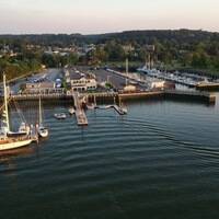
Glen Cove Inlet is a sliver of water located off Hempstead Harbor on the North Shore of Long Island. Glen Cove is eight miles southeast of New Rochelle and 12 miles south of Greenwich, CT. Inside the cove are four marinas (two with full service repairs), and two of these marinas make slips available to transient guests. Anchoring is not permitted here due to the narrow nature of the cove itself.
Navigating the Water:
Use NOAA Chart 12366.
From Hempstead Harbor, Mosquito Cove and Glen Cove are located about one mile south of the breakwater at Glen Cove Landing on the east shore of the harbor. The breakwater is marked by flashing red 5. Behind the midway breakwater in Hempstead Harbor is a designated anchorage, which is protected from Long Island Sound wakes.
From the breakwater (and flashing red 5), set a course for green can 1 and red nun 2 the entrance to Glen Cove, and then follow the inlet channel in past the semi-breakwatered entrance. All of the marinas, save for one, are located on the southern shore of the creek. Both larger facilities feature full-service yards with lifts and repairs. Depths in the cove average around six feet from the entrance to near the head of the cove.