Merrimack River Inlet
| Newburyport, Massachusetts United States | |
| 42° 49' 20.99'', -70° 48' 32.04'' | |
| Newburyport Harbor |


You might also consider...


About
Introduction:
The Merrimack River Inlet is located on the upper Massachusetts Coast about a 50-mile journey north of Boston and about 19 miles south-southwest of the Massacusetts-New Hampshire state line.
The Merrimack River gets its start in Franklin, NH, and then flows some 110-odd miles down to the Massachusetts coast at Newburyport where it empties into the Atlantic Ocean. Safe in most weather conditions with a deep and wide channel, entry into the Merrimack allows access to Newburyport, a town with an excellent selection of marinas, and additionally, provisioning and shopping opportunities ashore.
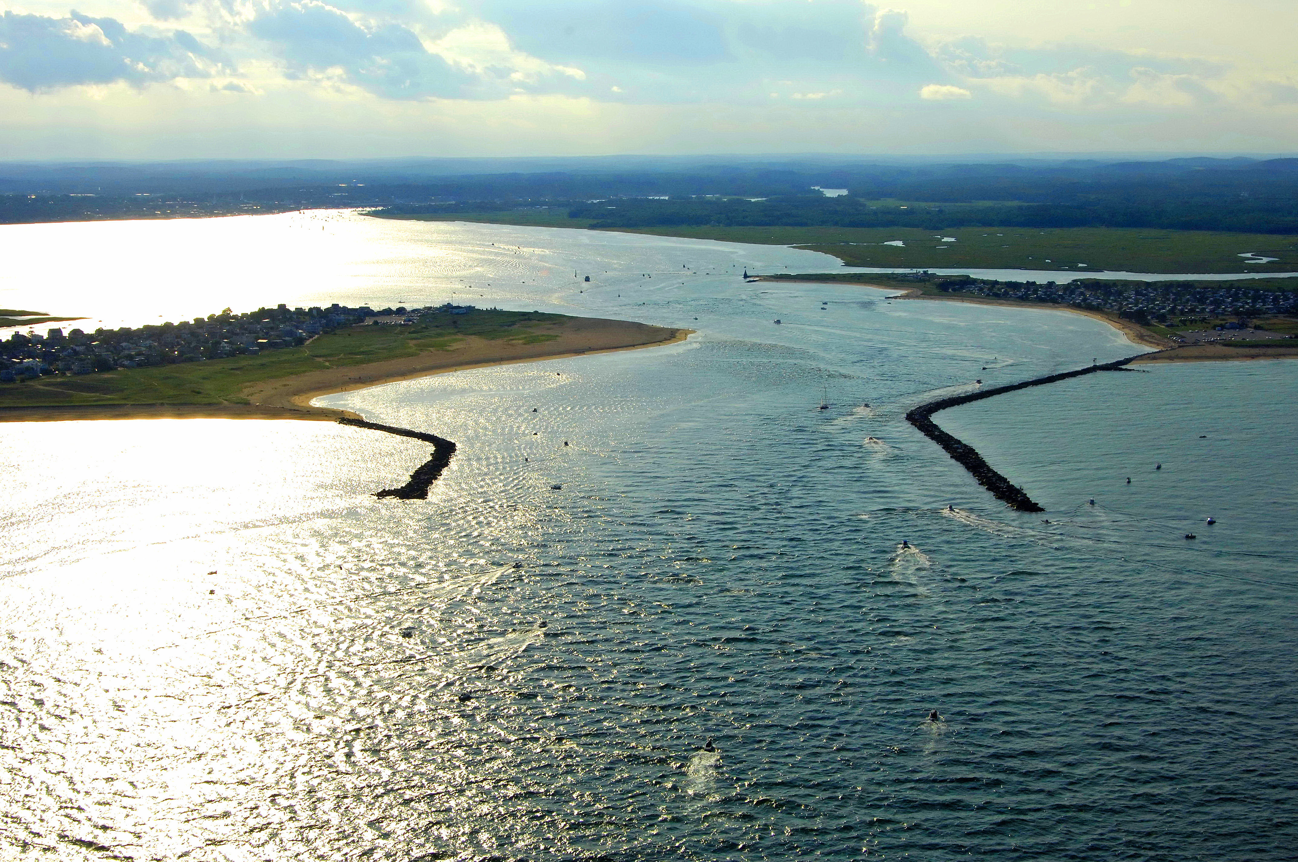
The image above is a view from the east-southeast looking west-northwest over the jettied Merrimack River Inlet where the Merrimack River empties into the Atlantic Ocean. To the left (south) is the northern tip of Plum Island, while to the right (north), Badgers Rock is visible. Farther off toward the horizon, the town of Newburyport is visible in the upper-left-hand portion of the image.
Navigating the Water:
Use NOAA Chart 13274.
The approach to Merrimack River begins about one mile southeast of the inlet at Morse (A) buoy MR. Morse (A) buoy MR is located at an approximate waypoint of N42 48.568 W70 47.050. Once you have safely navigated to Morse (A) buoy MR, set a course of about 313 degrees magnetic for approximately .7 miles to intercept green can buoy 3 (flashing red buoy 2 is available if you are approaching from the north).
Once you have navigated to green can 3, continue on toward the northwest until you find green can buoy 5 just east of the south inlet jetty (flashing red 4 is available on the north inlet jetty. Inside the inlet (reported channel depths of 10 feet), the passage continues to to the northwest until you come upon flashing green buoy 7 and a flashing white bar guide light. This white light is marked Rough Bar, and when it is active, the Coast Guard Has determined that the channel has shifted in such a way that makes the passage safer farther south toward flashing green buoy 7. Note the two-foot-deep shoal just southeast of flashing green 7. If in doubt, call ahead to the Coast Guard for advice.
After you have rounded the corner past flashing green buoy 7, plot a course of about 267 degrees magnetic for approximately .5 mile to intercept flashing red buoy 8, which marks the location of a nasty rock and sand shoal. Having successfully avoided the rock shoal and sand bar at flashing red buoy 8, set your sights toward green can buoy 11 and flashing green 13 farther to the west. From flashing green buoy 13, set a course of about 264 degrees magnetic for approximately .7 miles to pickup flashing green buoy 15, red nun buoy 16, flashing red (North Pier) 18, and then green can buoy 17, which marks a ledge to its south.
Having successfully navigated the approach channel from the Atlantic Ocean, you are now smack in the middle of Newburyport, where there are eight marinas at your disposal. Four of these marinas are located before a set of opening bridges that allow further travel upstream. Dawn Marina, Newburyport Central Waterfront Park and the Windward Yacht Yard accept transient guests at their slips. Additionally, the Windward Yacht Yard has a lift for haul-outs and repair.
Past the bridges there are four additional marinas, and while only two of them accept transient guests, three of them have extensive repair facilities and capabilities. The first bridge heading upstream is a 35-foot closed vertical clearance bridge that opens on request between 6 a.m. and 10 p.m. from May to October, and between 8 a.m. and 5 p.m. from November to April. The bridge opens with a one-hour advance notice at all other times. Hail the bridgetender on VHF Channel 13.
Local Notices to Mariners:
Local Notices to Mariners are available online from the U.S. Coast Guard.