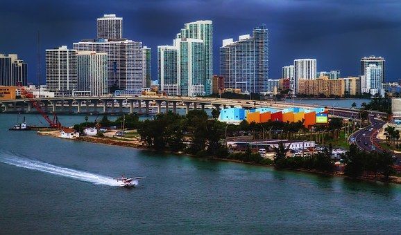

Miami Harbor
Miami, Florida United States
Marinas near Miami Harbor
| Name | Reviews | Max LOA | VHF | Dock Depth | Gas / Diesel | Lift / Crane | Wifi | Amps |
|---|---|---|---|---|---|---|---|---|
| Rickenbacker Marina | 100.0' | 16 | Low 7.0' | G$7.00/galD$6.00/gal | - | 30, 50, 100 | ||
| Marine Stadium Marina | - | 0.0' | 16 | Low 0.0 mHigh 0.0' | GYes | - | - | - |
| Vice City Marina | 150.0' | - | Low 6.0' | - | - | 30/50/100 | ||
| Untwine Marina | - | - | - | - | - | - | ||
| EPIC Marina | - | 165.0' | 16 | Low 15.0' | - | - | 200 | |
| Miami Outboard Club | - | 0.0 m | - | Low 0.0 mHigh 0.0' | - | - | - | - |
| Miamarina at Bayside | - | 0.0' | 16 | Low 11.0'High 0.0' | - | - | 30, 50, 100 | |
| One Island Park - Miami Beach | - | 800.0' | 11 | - | - | - | Up To: 3P 480v (600amps) | |
| Fisher Island Club and Marina | - | - | - | - | - | - | - | |
| City Centre Yachts | 150.0' | - | - | - | - | - | 30/50/100 | |
| Brickell Place Marina | - | - | - | - | - | - | - | - |
| Miami Yacht Club | 0.0' | - | Low 0.0 mHigh 0.0' | - | - | - | - | |
| IGY Yacht Haven Grande Miami at Island Garden | - | 550.0' | 71 | Low 23.0' | - | - | 50/100/200+ | |
| Museum Park Marina | - | 800.0' | - | - | - | - | - | - |
| Miami Beach Marina | 250.0' | 16 | Low 13.0'High 0.0' | G$4.09/galD$2.50/gal | LYes | 30 AMP, 50 AMP, 100 AMP |
Introduction:
The City of Miami is located in Southeast Florida, in Miami-Dade County on the Miami River, between the Florida Everglades and the Atlantic Ocean. Since its incorporation in 1896, the City has grown tremendously, transforming it into one of the worlds renowned yachting and tourism centers.??Miami is known for its diverse culture and ethnicities and is the largest municipality in Miami-Dade County. According to the 2000 census, it has a population of 362,470. By the year 2010 the population in the City is projected to rise to 390,191. Miami, which is known as the Gateway to Latin America, attracts a tremendous amount of foreign-born people, resulting in a large Latin American population that influences local culture.
The southern end of Miami, known as South Beach is the entertainment and boating center of the city. Besides laying out on the beach, people enjoy shopping, eating at local restaurants, checking out the art at local museums, and just taking in the scenes of the city. Miami is completely surrounded and pierced by water, and as such, there are dozens of marinas, from small, family-operated affairs to large resort marinas that cater to megayachts. ??[i]Portions Courtesy City of Miami[/i]
Navigating the Water:
Use NOAA Charts 11465 and 11467.
Government Cut is the primary ocean entrance to Miami and is capable of handling the largest of cruise ships and the heaviest freighters. With this in mind, be sure to stay on your feet and keep an eye out for commercial traffic such as tugs, barges, cruise ships and container carriers as you move in and around the Miami area.
From the Atlantic, first pick up red and white Morse (A) buoy M about three miles northeast of the inlet jetties, and then follow flashing green buoy 1, flashing red buoy 2, flashing green buoy 3, quick flashing red buoy 4, and flashing green buoy 5 as you use the Miami Entrance Range to help guide you in. Once you have cleared flashing green buoy 5, you will then follow in the long succession of lighted buoys into the jetties at Government Cut itself.
Inside the inlet to starboard is Meloy Channel, which has many marinas for transient guests. If you are cruising the Miami area via the Atlantic Intracoastal Waterway route, see our detailed images and schedules for the many opening bridges that crisscross Biscayne Bay.
Local Notices to Mariners:
Local Notices to Mariners are available online from the U.S. Coast Guard.
Transportation:
The Miami International Airport is located about ten miles west of town off Route 195, and has major carrier service with flights to connecting airports in the U.S. and abroad. Shuttle and taxi service are available through the airport, or cab service can be obtained in town for the ten-mile ride. Bus service is provided by the Miami Dade County Transit, and the system runs busses in and out of the nooks and crannies of the city at regular schedules.
For detailed bus schedules or to arrange shuttle service to the airport, see the Helpful Links section below.
Where to Eat, Drink, and Provision:
Good Eats: Kush by Local, Versailles!
Events and Things To Do:
With a constant buzz in the air, it might be difficult to find downtime in Miami Harbor! Miles of beaches and shopping galore. Check out more at www.miamiandbeaches.com!
Be sure to explore around Wynwood, Coconut Grove, Little Havana, and Aventura!
Visit The Villa Casa Casuarina, home of Gianni Versace.
For the museum types: www.artbasel.com