


Great Guana Cay Harbor
Abacos Bahamas
Marinas near Great Guana Cay Harbor
| Name | Reviews | Max LOA | VHF | Dock Depth | Gas / Diesel | Lift / Crane | Wifi | Amps |
|---|---|---|---|---|---|---|---|---|
| Orchid Bay Yacht Club & Marina | - | 0.0 m | 16 | Low 13.0'High 0.0 m | GNearbyDNearby | - | - | |
| Guana Hideaways Marina | - | - | - | - | - | - | - | - |
| Baker's Bay Golf Club & Marina | - | - | - | Low 12.5' | - | - | 50, 100 | |
| Edwin's Boat Yard #1 | 0.0 m | - | Low 0.0 mHigh 0.0 m | - | - | - | - | |
| Edwin's Boat Yard #2 | - | 0.0 m | - | Low 0.0 mHigh 0.0 m | - | - | - | - |
| Man-O-War Marina | 115.0' | 16 | Low 8.0'High 7.5' | GYesDYes | - | 30A, 50A, Double 50A | ||
| Marsh Harbour Marina | 140.0' | 16 | Low 8.0' | - | - | 30, 50 | ||
| Rich's Rentals | - | 0.0 m | - | Low 0.0 mHigh 0.0' | - | - | - | - |
| Abaco Outboard Engines | - | 0.0 m | - | Low 0.0 mHigh 0.0 m | - | - | - | - |
| Mangoes Marina | - | 0.0 m | - | Low 0.0 mHigh 12.0' | GYesDYes | - | - | - |
| Conch Inn Yacht Club & Marina | 120.0' | 16 | - | GYesDYes | - | 20, 30, 50 | ||
| Marsh Harbour Public Dock | - | - | - | - | - | - | - | - |
| Rainbow Boat Rentals | - | - | - | - | - | - | - | - |
| Harbour View Marina | 200.0' | 16 | - | G$7.50/galD$7.90/gal | - | - | ||
| Longs Landing | - | - | - | - | - | - | - | - |
Introduction:
Great Guana Cay sits just north of Marsh Harbor in the Abacos island chain. To the northwest of Great Guana Cay are Green Turtle and Whale cays, and to the southeast, Scotland and Man-O-War cays. Marsh Harbour lies only 7 miles to the south of Guana Cay and Treasure Cay is just 20 miles to the northwest.
This entire stretch of islands makes up one of the most visited and widely popular cruising areas in the Abacos due to the good protection afforded in the Sea of Abaco and the location of the harbors on the cays that protect boaters from the strong winter northers that can blow through quite frequently.
There are four good harbors on the south side of of Great Guana Cay, and from the northwest side of the island to the southeast, they line up as follows: Bakers Bay, Crossing Bay, Fishers Bay and Settlement Harbor.
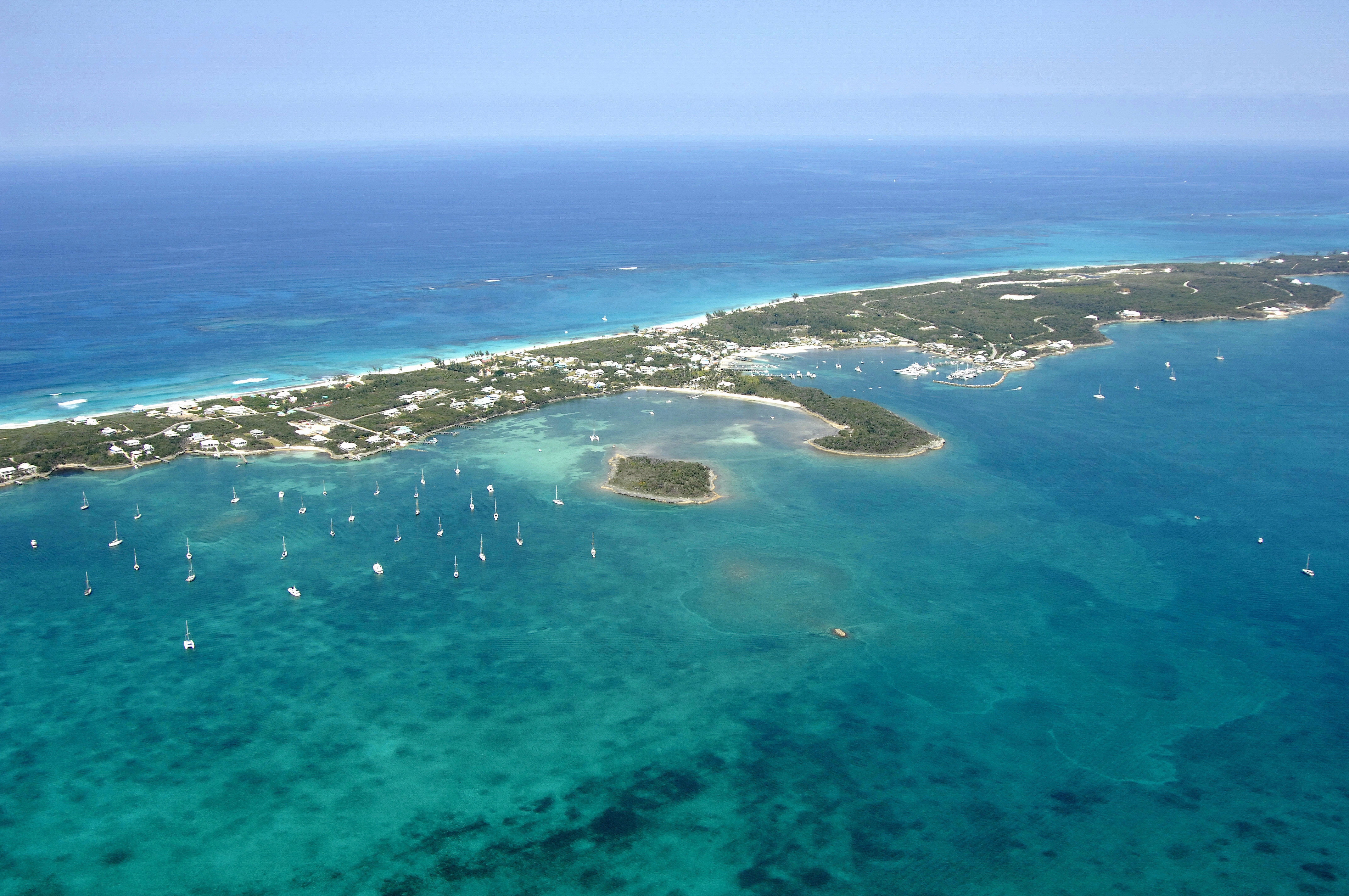
Fishers Bay is visible in the image above in a view from the northwest where all of the anchored boats lie. Delias Cay is the small island just off the right (south) side of the anchorage. On the north side of the anchorage in Fishers bay is the Blue Water Grill with a small dock, and farther in is the Guana Beach Sunset Resort.
Farther down you can see Settlement Harbor, where the well-protected and equipped Orchid Bay Marina is located. Ashore in Settlement Harbor are many resorts, a few hotels and good dining. If you are cruising Great Guana Cay and need to be close to the best facilities, Settlement Harbor is your location. Ashore are good markets, a liquor store, gift shops, and a good beauty shop to get hair cuts or other beauty services.
Bakers Bay is out of the image, but was originally dredged and developed as a cruise ship depot. Bakers Bay is now a protected anchorage that is located on the far northwest end of Guana Cay. The cruise depot has been abandoned for at least 16 years. There are no facilities here.
Crossing Bay (also out of the image) is located just to the northwest of Fishers Bay and offer moderate protection, but as with Bakers Bay, no facilities.
Navigating the Water:
Bakers Bay is very easy to enter from either the west or southeast. Approaching from the northwest end of Guana Cay is not recommended, due to the multitude of reefs and islands that jut out around Gumelimi Cay. Depths in Bakers Bay average 6 to 9 feet, and there is good protection from most direction sans the south and southeast. Development is afoot at Bakers Bay, with a marina, golf course, waterfront homes and other amenities planed as part of a large-scale development. If you have a penchant for shells and beach combing, the sandy shores here are among the best for finding that perfect take home collectable.
Settlement Harbor is by far the deepest and easiest to enter harbor on Great Guana Cay. Depths in the entrance channel average 8 to 9 feet. The only warning about Settlement Harbour would be to note that it is open to winds from the south, and with a long fetch across the Sea of Abaco, things can get a little rough.
Fishers Bay, Crossing Bay and Bakers bay all offer similar (if not a bit shallower) depths, and also come with the warning of finding better refuge in a southerly wind.
Local Notices to Mariners:
See our Local Notices to Mariners blog for updates on the latest conditions and advisories for this area.