


North Creek Harbor
Grand Turk, Turks and Caicos Islands
Marinas near North Creek Harbor
| Name | Reviews | Max LOA | VHF | Dock Depth | Gas / Diesel | Lift / Crane | Wifi | Amps |
|---|---|---|---|---|---|---|---|---|
| Grand Turk Fishing Boat Dock | - | - | - | - | - | - | - | - |
| Grand Turk Marine Police Department | - | - | - | - | - | - | - | - |
| Grand Turk Tourist Office | - | 0.0 m | - | Low 0.0 mHigh 0.0 m | - | - | - | - |
| Grand Turk Public Dock | - | - | - | - | - | - | - | - |
| Salt Dock | - | - | - | - | - | - | - | - |
| Seaview Marina | - | - | - | - | - | - | - | - |
| East Bay Dinghy Landing | - | - | - | - | - | - | - | - |
| Fish Plant | - | - | - | - | - | - | - | - |
| North Caicos Yacht Club & Marina | - | - | - | - | - | - | - | - |
| Blue Haven Marina | - | - | 16 | - | GYesDYes | - | - | |
| Turks & Caicos Yacht Club | - | 0.0 m | - | Low 0.0 mHigh 0.0' | - | - | - | - |
| The Marina at South Bank | - | - | - | - | GYesDYes | LYesCYes | - | - |
| Southside Marina | - | 0.0 m | - | Low 0.0 mHigh 0.0 m | - | - | - | - |
| Turtle Cove Marina | - | 0.0 m | - | Low 0.0 mHigh 0.0 m | - | - | - | - |
| Public Dock At Watkin Park | - | - | - | - | - | - | - | - |
Introduction:
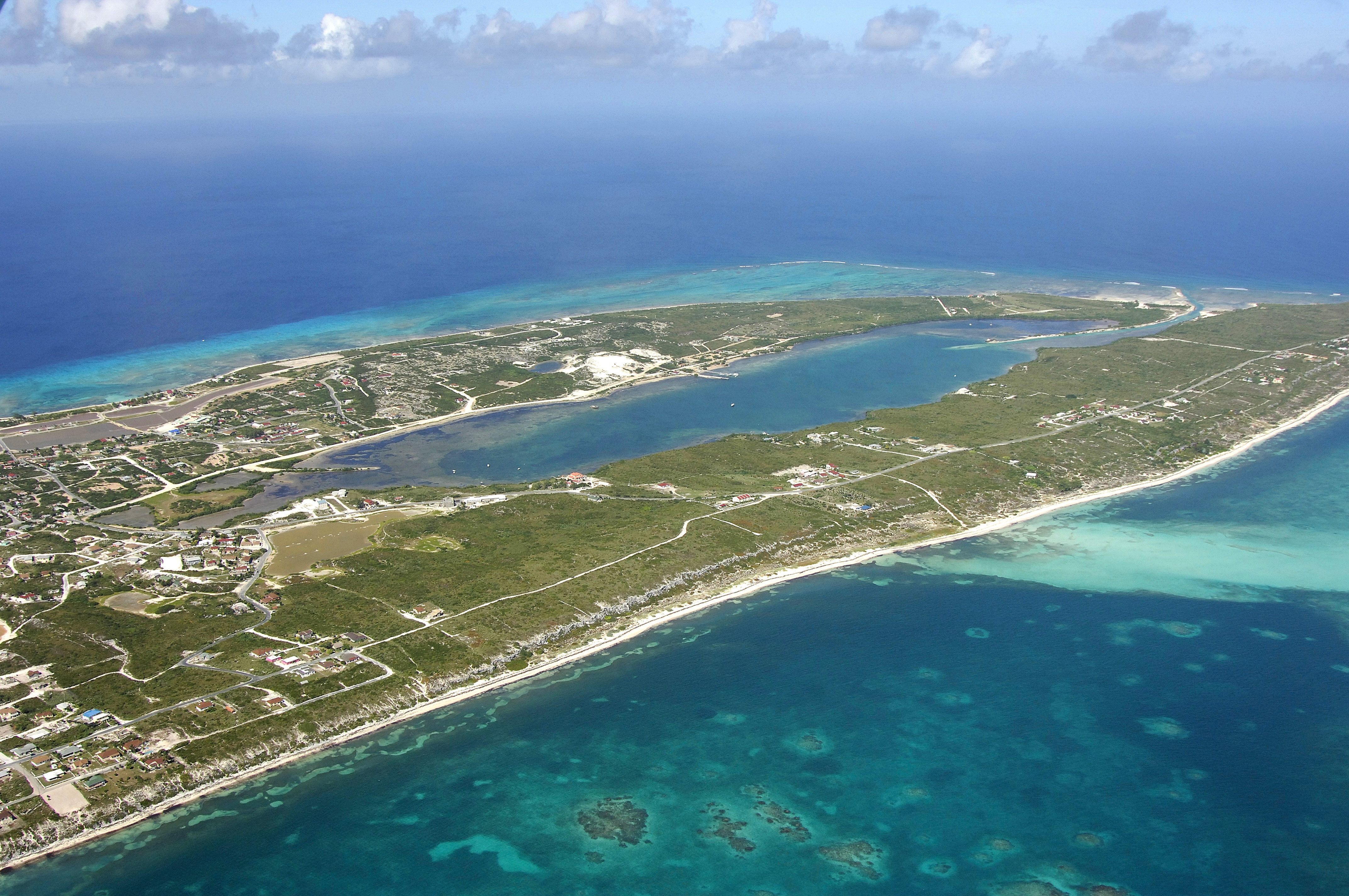
Situated on the north end of Grand Turk Island, North Creek is the largest protected body of water on the island. This protection comes at a price, however. The cut that leads into North Creek from the Atlantic Ocean can be dangerous and impassable when winds clock out of the north or east.
History:
Although there is much debate as to where Christopher Columbus actually landed on his first expedition to the New World, many people believe he landed here at North Creek. For this reason, North Creek is often called Columbus Lake.
Navigating the Water:
Although the entrance cut to North Creek has good depths (6 feet in most places), cruisers must often wait for a proper weather window to be able to pass through. In northerly winds, waves crash and break in and around the cut to North Creek making passage impossible. Even in winds from other directions, swells can break all over the cut and cause dangerous conditions.
Inside North Creek is an idyllic tropical anchorage that is enjoyed by many yachtsman every year. There is protection from all directions, and despite the large thickets of trees and palms, mosquitoes and other bugs are not very bothersome.
Local Notices to Mariners:
See our Local Notices to Mariners blog for updates on the latest conditions and advisories for this area.