


No Name Cay Harbor
Abacos Bahamas
Marinas near No Name Cay Harbor
| Name | Reviews | Max LOA | VHF | Dock Depth | Gas / Diesel | Lift / Crane | Wifi | Amps |
|---|---|---|---|---|---|---|---|---|
| Roberts Dock and Cottages | - | - | - | - | - | - | - | - |
| Roberts Marine | - | - | - | - | - | - | - | - |
| Black Sound Marina | 0.0 m | - | Low 0.0 mHigh 0.0 m | - | - | - | - | |
| Beach Weekend Bahamas | - | 16 | - | - | - | 30, 50, 100 | ||
| New Plymouth Public Dock | - | 0.0 m | - | Low 0.0 mHigh 0.0 m | - | - | - | - |
| New Plymouth Government Dock | - | 0.0 m | - | Low 0.0 mHigh 0.0 m | - | - | - | - |
| The Other Shore Club | 0.0 m | - | Low 0.0 mHigh 0.0 m | - | - | - | - | |
| Abaco Yacht Services | - | 0.0 m | - | Low 0.0 mHigh 0.0' | - | - | - | - |
| Treasure Cay Resort, Marina & Golf Course | 130.0' | 16 | Low 0.0'High 0.0' | G$5.19/galD$5.35/gal | - | 30/50/100 | ||
| Pineapple Point Resort | - | - | - | - | - | - | - | - |
| Dolphin Marine | - | 0.0 m | - | Low 0.0 mHigh 0.0 m | - | - | - | - |
| Bluff House Yacht Club & Marina | - | 0.0 m | - | Low 0.0 mHigh 0.0' | GYesDYes | - | - | - |
| Green Turtle Club & Marina | 0.0' | - | Low 0.0'High 0.0' | GYesDYes | - | - | ||
| Fiddler’s Green Cottages and Marina | - | - | - | Low 0.0'High 0.0' | - | - | - | |
| Baker's Bay Golf Club & Marina | - | - | - | Low 12.5' | - | - | 50, 100 |
Introduction:
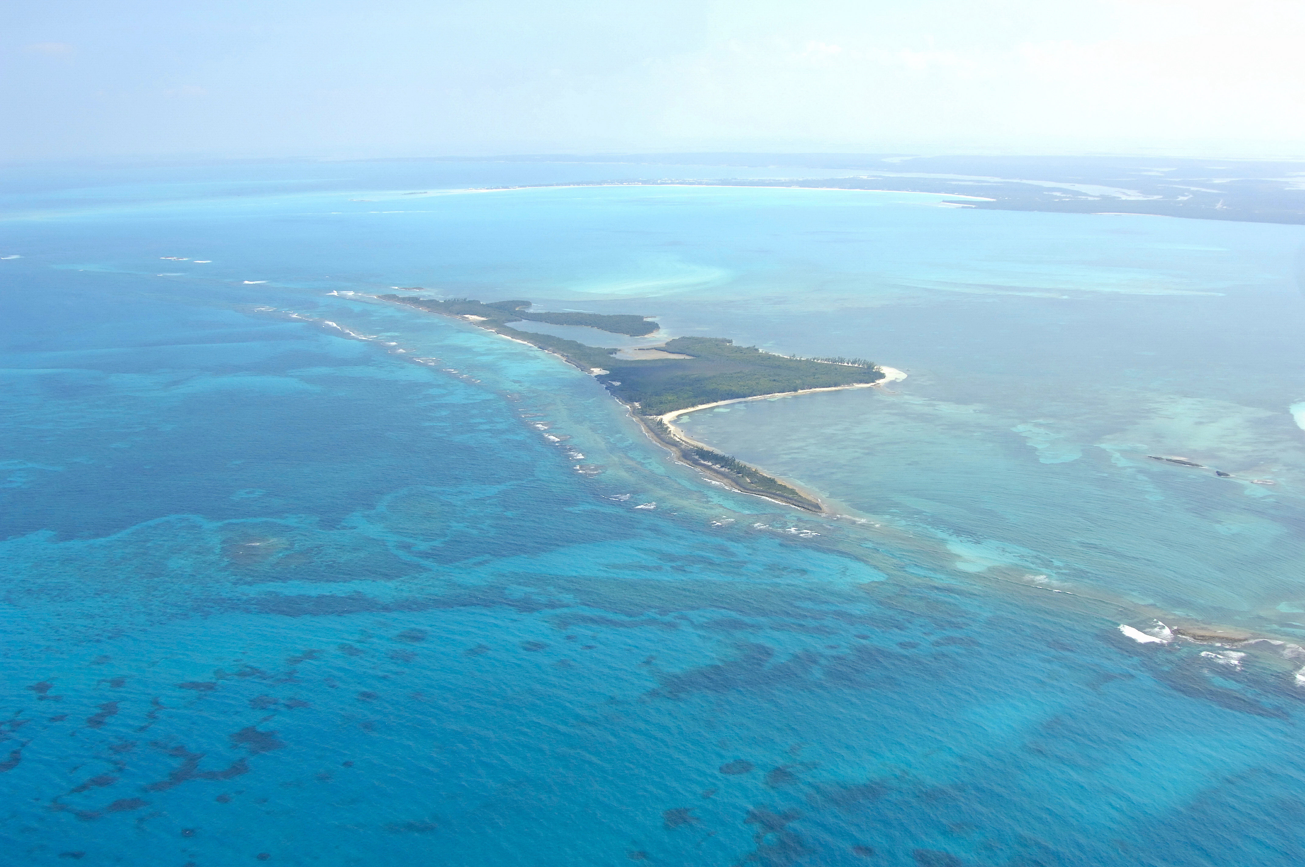
No Name Cay is a small sliver of lush, tree-covered sand located just southeast of Green Turtle Cay in the northwest portion of the Sea of Abaco. Though it only has an anchorage for day use, the island and surrounding reefs are beautiful and ripe for exploration.
Navigating the Water:
There are shoals that extend south from Green Turtle Cay and south from No Name Cay itself that deserve your attention. Once you have cleared either of these shallow reefs on the north or south side of the island, turn toward the east and anchor off the entrance to the small lagoon. There is no anchoring in the lagoon - depths are too shallow and the bottom is very rocky. Only explore here with your dinghy and at high tide.
Local Notices to Mariners:
See our Local Notices to Mariners blog for updates on the latest conditions and advisories for this area.
Things To Do/Local Events:
Aside from snorkeling, beach combing, sailing, and other water activities, there is an active and vibrant calendar of other scheduled events in the Abacos. See our Helpful Links section below for a detailed calendar of events.
Transportation:
There is no airstrip on No Name Cay, so arriving here by boat is your only option. The nearest airport is Treasure Cay Airport about 7 miles to the west, but the Marsh Harbour International is 20 miles away to the southeast and much better equipped (daily commercial jet service).