Shark River Inlet
| Belmar, New Jersey United States | |
| 40° 11' 8.16'', -74° 0' 24.11'' | |
| Bricktown Harbor |


You might also consider...


About
Introduction:
The Shark River is a major boating area that is located on the Upper New Jersey Coast about 20 miles south of Sandy Hook and six miles north of the Manasquan River Inlet.
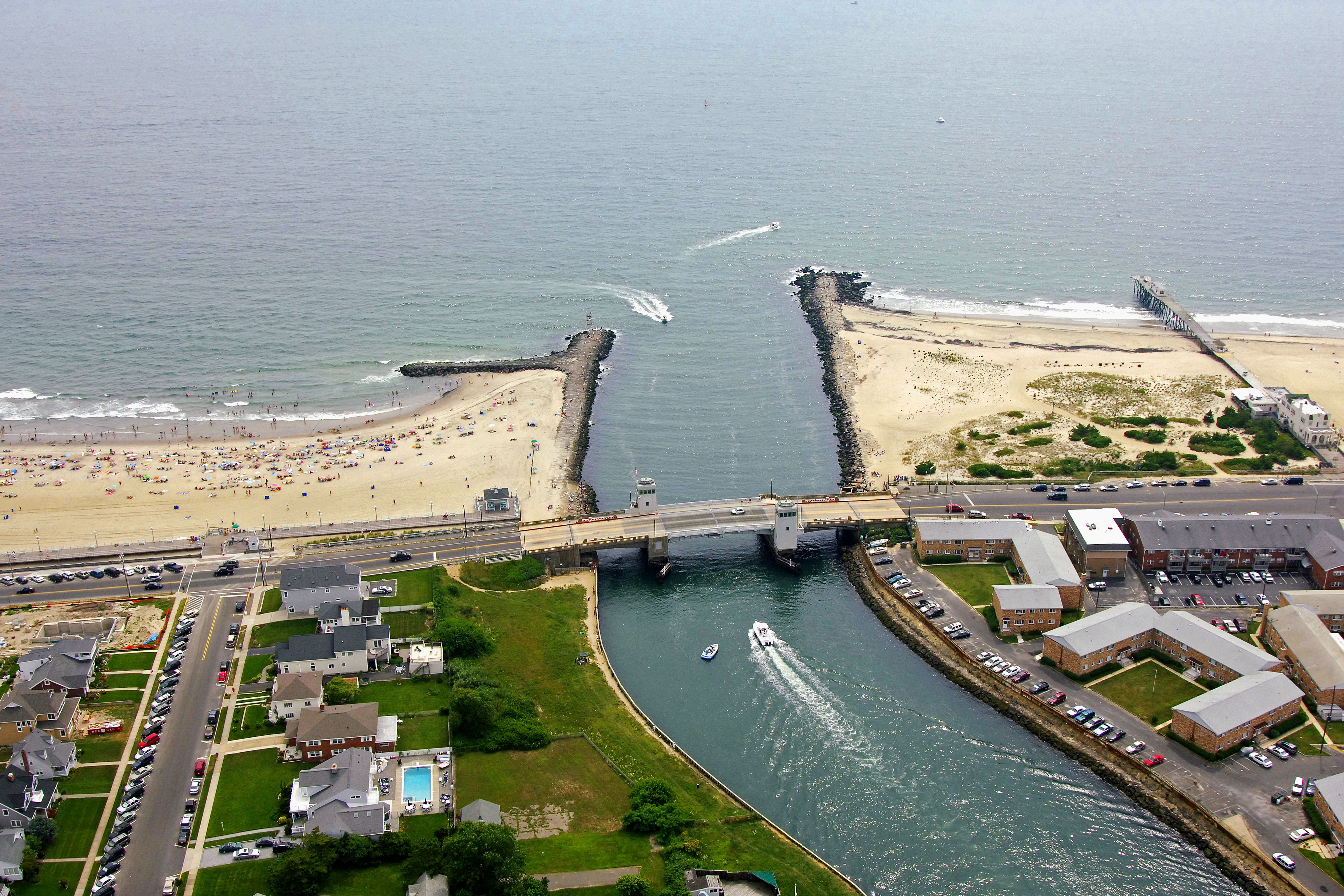
The image above is a view from the east looking west over the Shark River where it empties into the Atlantic Ocean. To the left (south) of the inlet is the town of Belmar, while to the right (north) is Avon-by-the-Sea. The Shark River (more like a lake than a river) is visible in the top portion of the river, while Ocean Avenue Bascule Bridge can be seen crossing the Shark River Inlet near its mouth.
Inside the inlet are a variety of marine service that are based around Shark River Island and Shark River Hills on the back side of the Shark River. Of the ten marinas in the Shark River area, six accept transient guests, and four of them have lifts for haul-outs and repairs. If you are in need of a quick gas or diesel fix, A.P.s Inlet marina is the closest fuel dock to the ocean and is located on the south side of the river before the Main Street Bascule Bridge .
Navigating the Water:
Use NOAA Chart 12324.
The Manasquan River Inlet is reached via an eastern approach from the Atlantic Ocean. Red and white Morse (A) buoy SI marks the initial approach to the Shark River from the Atlantic and is located near waypoint N40 11.146 W74 00.039. Once you have picked up red and white Morse (A) buoy SI, set an approximate course of 296 degrees magnetic for three-tenths of a mile to intercept flashing green 1 and flashing red 2 on the south and north inlet jetties, respectively.
Inside the inlet jetties you will have to negotiate the Ocean Avenue Bascule Bridge, which has a closed vertical clearance of nine feet. The bridge leaves were under repair in 2006 with an altered opening schedule as a result. The bridge normally opens on demand, but hail the bridge tender on VHF 13 well in advance of your arrival to ascertain the current schedule. Currents can be amazingly swift at the inlet and negotiating the bridge if you have to wait can induce a little anxiety in even the best of skippers.
Local Notices to Mariners:
Local Notices to Mariners are available online from the U.S. Coast Guard.