Smith Creek Inlet
| Sewaren, New Jersey United States | |
| 40° 32' 58.93'', -74° 15' 12.96'' | |
| Perth Amboy Harbor |


You might also consider...


About
Introduction:
Smith Creek is located off the Arthur Kill River east of Staten Island and north of the town of Perth Amboy. Just three miles up the Arthur Kill River, Smith Creek is 18 miles southwest of The Battery in New York City and 13 miles northwest of Sandy Hook.
Smith Creek is a deceivingly small patch of water that breaks off Arthur Kill west of Staten Island in the towns of Port Reading and Seawaren. The reason the creek is deceivingly small is because the entire creek is packed to the gills with nine marinas within its .6 mile navigable length.
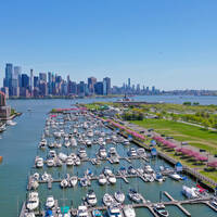
Unfortunately, of the nine marinas located here, none of them publicly advertise the availability of transient slips, but you May be able to arrange for a space by calling ahead and dealing directly with the marina. The image above is a view from the south looking north over the entrance to Smith Creek where it empties into Arthur Kill west of Port Socony.
Navigating the Water:
Use NOAA Chart 12327.
Smith Creek is reached just off the Port Socony Reach west of Port Socony and just north of Boynton Beach. Boaters usually arrive in the area from the south by navigating through the Arthur Kill entrance at Perth Amboy, and this is the route we will discuss.
To enter the southern terminus of the Arthur Kill River, first set a course to intercept flashing red 52, which is located near waypoint N40 29.432 W74 14.421. Once you have picked up flashing red 52, change course to the northwest to follow flashing red buoy 56 and flashing red 58 (at Ward Point), and then red nun buoy 60 farther to the north.
From here, the extensive mooring field of the Raritan Yacht Club will be visible to port, with the Perth Amboy City Marina located just to its north. Continue north around the bend at Tottenville and then toward flashing red buoy 2 just south of the Outerbridge Crossing Cantilever Bridge (143-foot vertical clearance).
Once under the bridge, you can pick up the Outerbridge Reach range light, which will guide you toward Smith Creek. You will pass flashing red buoy 4, and then flashing green buoy 5, at which point the range changes to the Port Socony Range at Woodbridge Creek. Flashing red buoy 6,red nun buoy 8 and then flashing red buoy 10 will put you at the mouth to Smith Creek.
Depths in the creek allow for shallow-draft boaters only - typically small power boats and family cruisers that draw less than 3 to 3.5 feet.
Local Notices to Mariners:
Local Notices to Mariners are available online from the U.S. Coast Guard.