Sakonnet River North Inlet
| Tiverton, Rhode Island United States | |
| 41° 39' 6.12'', -71° 12' 45.01'' | |
| Mount Hope Bay |


You might also consider...


About
Introduction:
The Sakonnet River leads down behind the Aquidneck Island and forms the third sliver of water in the Newport area. Starting out at Mount Hope Bay to the north, and finally emptying into the Atlantic Ocean at Sakonnet Point, the Sakonnet River is approximately 13 miles long from end to end.
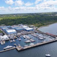
Along its length you will find a variety of marine facilities, and a good number of them cater to transient guests. In the Town of Tiverton there is a unique little harbor of refuge bounded by two bridges to the north and an unusual storm barrier to the south.
Navigating the Water:
Use NOAA Chart 13221.
From Mount Hope Bay, exit the main channel at red and green buoy MH (flashing red 2+1) and head east toward green can 3 and flashing red bell buoy 4 at Common Fence Point. Once you have cleared Common Fence Point, chart a course for green can 17, and then the center span of the fixed (65-foot clearance) and swing (12-foot closed vertical clearance, opens on demand) bridges at the Hummocks.
Before the bridges are two marinas, one to the east, and one to the west in Cedar Island Pond. Only the facility on the east shore accepts transients. Inside the protected area between the bridges and the protected storm wall at Tiverton are four additional marinas and a field of moorings.
Keep in mind that the current here is quite strong, and the maneuvering room is slim in quite a few places. With good depths throughout you should encounter no draft issues, but several boats each year temporarily loose control of their boats here due to their inattention toward the current flow.
Local Notices to Mariners:
Local Notices to Mariners are available online from the U.S. Coast Guard.