


Castine Harbor
Castine, Maine United States
Marinas near Castine Harbor
| Name | Reviews | Max LOA | VHF | Dock Depth | Gas / Diesel | Lift / Crane | Wifi | Amps |
|---|---|---|---|---|---|---|---|---|
| Castine Town Dock | - | 0.0 m | - | Low 0.0'High 0.0' | - | - | - | - |
| Eaton's Boat Yard | - | 200.0' | 9 | Low 11.0'High 0.0' | GYesDYes | LYes | 30, 50, 100 | |
| Castine Yacht Club | - | 0.0 m | - | Low 0.0'High 0.0 m | - | - | - | - |
| Seal Cove Boatyard | - | 0.0' | - | Low 0.0'High 0.0' | - | - | - | - |
| Islesboro Marine Enterprises | - | - | - | - | - | - | - | - |
| Seal Ledge Marina | - | - | - | - | - | - | - | - |
| Bucks Harbor Yacht Club | - | 0.0' | 9 | Low 0.0'High 0.0' | - | - | - | - |
| Buck's Harbor Marine | 65.0' | 9 | Low 20.0' | G$6.01/galD$5.99/gal | - | 30 | ||
| Stockton Harbor Yacht Club | - | - | - | - | - | - | - | |
| Searsport Public Landing | - | - | 16 | - | - | - | - | - |
| Downeast Yacht Services | - | - | - | - | DYes | - | - | - |
| Town Dock at Grindle Point | - | 0.0 m | - | Low 0.0 mHigh 0.0' | - | - | - | - |
| Pendleton Yacht Yard | - | - | - | - | - | - | - | - |
| Warren Island State Park | - | - | - | - | - | - | - | - |
| Belfast Marina | - | - | Low 8.0' | - | - | - | 30/50 |
Local Notices to Mariners:
Local Notices to Mariners are available online from the U.S. Coast Guard.
Transportation:
Belfast Municipal Airport is the closest larger general aviation airport to Castine. There are a few airports closer, but most of them are grass airstrips.
Knox County Regional, a good 1.5-hour drive is the closest major airport with charter air service.
Helpful Links:
Navigating the Water:
Use NOAA Chart 13305.
Castine Harbor is reached via an approach from the west through Penobscot Bay just east of Isleboro Island. If you are approaching at night or from farther out in Penobscot Bay, the Dice Head Light house stands 27 feet above the water with a white flashing light every six seconds.
Red and white buoy CH is located at an approximate waypoint of N44 22.489 W68 49.062, and marks the location of the initial approach into Castine Harbor. Once you have picked up red and white buoy CH, set an approximate course of 61 degrees magnetic for about .3 mile to pickup green nun buoy 1, which marks the location of Otter Rock Shoal south of Dice Head. From here, the Castine waterfront should be clearly visible to port.
If you decide to head farther up toward South Bay or Smith Cove, be sure to honor red daybeacon 2, which marks the location of Hosmer Ledge on the south side of the passage.
Introduction:
The town of Castine and Castine Harbor are located on upper Penobscot Bay east of Isleboro Island and north of Cape Roster. Castine is 18 miles north of Vinalhaven and 25 miles west (as the bird flies) of Mount Desert Island.
There are four marine service and marina facilities on the Castine waterfront, and of the four, two of them accept transient guests. Both gas and diesel fuels are available at Eatons Boatyard, and they can also undertake any in-the-water repairs you may need, but unfortunately, they have no lift. In fact there are no lifts for haul-outs in Castine at all. There are moorings in the harbor (exposed), and additionally, there are plenty of places to drop the hook in the surrounding areas.
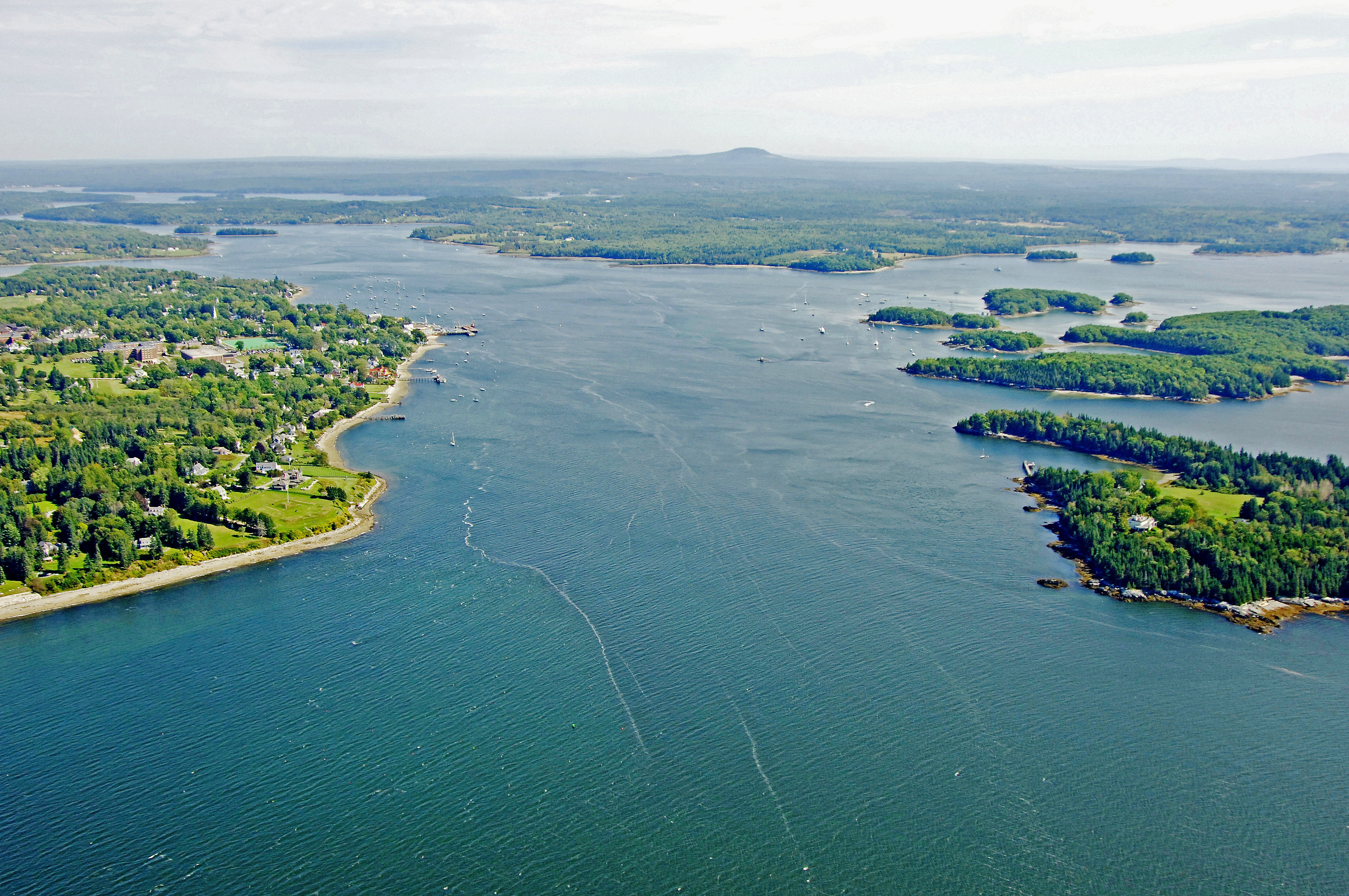
The image above is a view from the west looking east over the entrance to Castine Harbor near Dice Head. Off to the right (south), a group of islands including Naultilus Island, Grays Island, High Tide Island, Hospital Island and Great Island can be seen. To the left (north) is the town of Castine waterfront. Lastly, off in the upper right-hand corner is the entrance to Smith Cove, which has an excellent and pristine anchorage.
History:
More than 100 historic markers can be found in this town, which is characterized by its 18th century architecture. Major landmarks include Fort George, built by the British in 1779 and partially restored as a state memorial, and Fort Madison, earthwork remnants built by the Americans in 1811, occupied by the British during the War of 1812 and reconstructed during the American Civil War.
[i]Information courtesy Town of Castine.[/i]