


Newport News Harbor
Newport News, Virginia United States
Marinas near Newport News Harbor
| Name | Reviews | Max LOA | VHF | Dock Depth | Gas / Diesel | Lift / Crane | Wifi | Amps |
|---|---|---|---|---|---|---|---|---|
| Fairlead Boat Works | - | 0.0' | - | Low 0.0'High 0.0' | - | LYes | - | - |
| Leeward Municipal Marina | - | 46.0' | 16 | Low 8.0'High 6.0' | G$5.199/galD$4.989/gal | - | - | - |
| Hampton Marina and Dry Storage | - | - | 16 | - | G$5.40/galD$5.15/gal | LYes | 30 | |
| Merrimac Shores Marina | - | - | - | - | - | - | - | - |
| Safe Harbor Bluewater | 200.0' | 16 | Low 10.0' | G$5.20/galD$5.40/gal | LYes | 50 | ||
| The Batten Pocket | - | - | - | - | - | - | - | - |
| Hampton Yacht Club | - | - | - | GNearby | - | - | - | |
| Custom House Marina | - | 0.0' | - | Low 0.0 mHigh 0.0' | - | - | - | - |
| Rescue Yacht Basin | - | 0.0' | - | Low 0.0 mHigh 0.0' | - | - | - | - |
| The Docks at Downtown Hampton | - | 16 | Low 12.0' | - | - | - | ||
| Brown's Marina | - | - | - | - | - | LYes | - | - |
| Brown's Marina | - | 0.0' | - | Low 0.0'High 0.0' | - | - | - | - |
| The Marina at 37 North (FKA: Old Point Comfort Marina) | 50.0' | 16 | Low 13.0' | G$3.60/galD$3.25/gal | LYes | - | 30, 50 | |
| Norfolk Naval Sailing Center | 90.0' | 71 | Low 10.0' | - | - | - | ||
| Bennett's Creek Marina | 80.0' | 16 | Low 7.0'High 0.0' | G$5.99/galD$5.39/gal | - | 30, 50 and 100 |
Transportation:
Local public transportation is provided by Hampton Roads Transit, which runs on regular schedules around the area and also to the Norfolk International Airport.
The Norfolk International Airport features regularly scheduled major air service with connecting service to larger locations. Shuttle and taxi service to and from the facility is available by making arrangements with the airport. For transit schedules and shuttle service to the airport, see the Helpful Links section below for more details.
Helpful Links:
<a rel='nofollow' href=http://www.newport-news.org/visitors/about-our-city/overview-and-fun-facts/
Newport News Tourism
Local Notices to Mariners:
Local Notices to Mariners are available online from the U.S. Coast Guard.
Things To Do/Local Events:
One of the most popular attractions in Newport News is the Mariners Museum, which has dozens of interactive exhibits on the maritime history of the Newport News area, including the dramatic USS Monitor Center, which brings to life the Battle of the Ironclads and offers visitors the chance to walk the deck of a full-scale Monitor replica. The world-class collection includes 35,000 maritime paintings, artifacts, figure heads, ship models, decorative arts and small craft from around the world.
At the Virginia Living Museum, visitors can see red wolves, bald eagles, a loggerhead sea turtle, fish with no eyes and frogs that change colors. Living exhibits depict Virginias natural heritage from the mountains to the sea, including a cypress swamp and a mountain cove. An observatory, state-of-the-art digital planetarium theater, outdoors boardwalk, living greenhouse and conservation garden add to the experience.
If you do not mind hopping on the bus or grabbing a cab, Hampton Roads, Norfolk and Virginia Beach are all close by, each with their own unique list of activities. See the Helpful Links section below for more detailed information and a calendar of events for the Newport area.
Introduction:
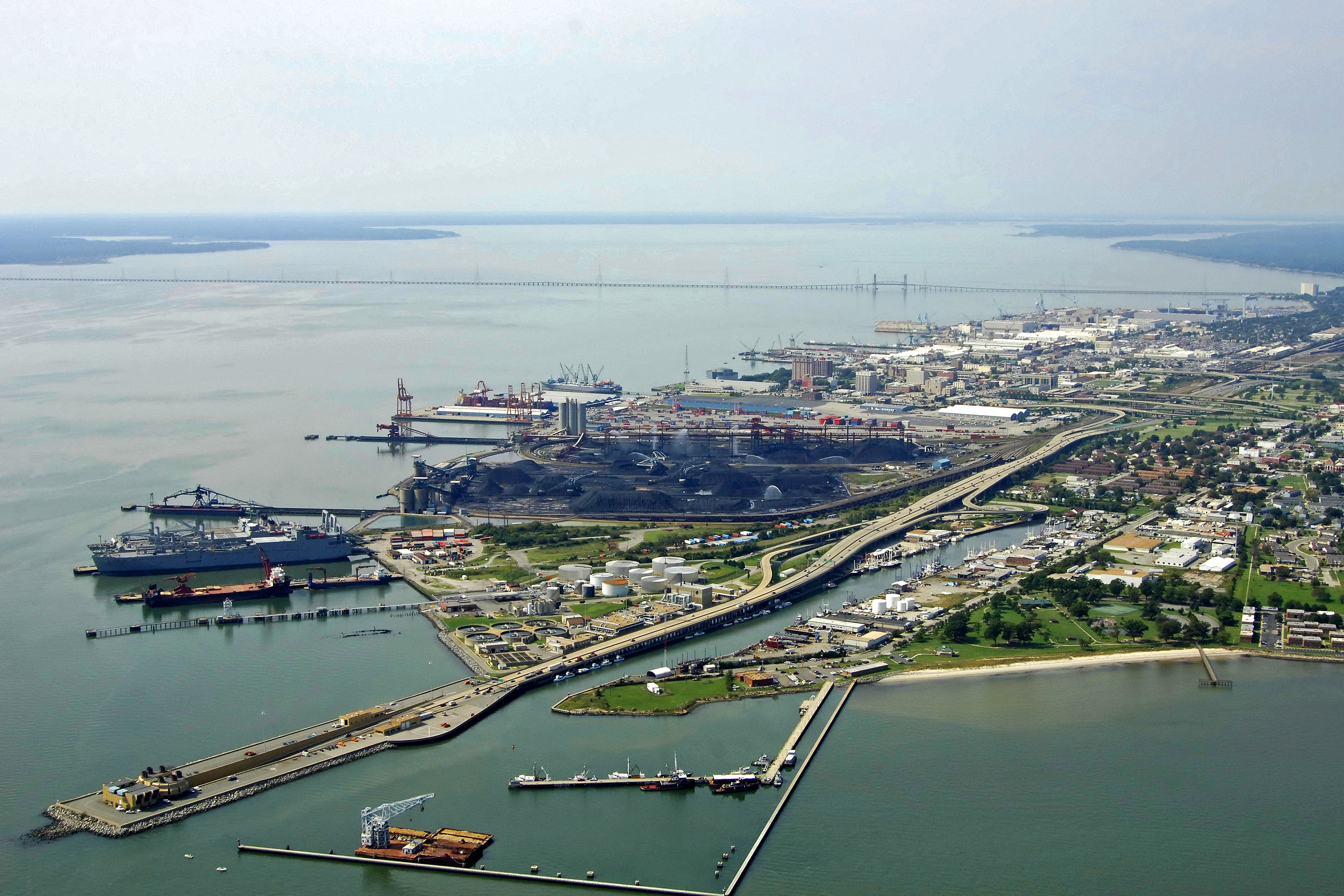
Newport News, located just west of the city of Hampton Roads on the James River, is not only a bustling center of boating activity in the region, but also has rich maritime roots (the U.S.S. Merrimac sailed here) and is home of the company that builds the biggest warships on Earth - United States Navy aircraft carriers. There are several marine facilities here, but most of the Newport News waterfront is dedicated to commercial shipping and shipbuilding.
History:
No one knows for sure where Newport News got its name, but "Newportes Newes" first appears in the Virginia Company records in 1619, making it one of the oldest place names in the New World. The most widely accepted folktale is that the city is the namesake of Captain Christopher Newport, commander of Susan Constant, which was the flagship of the three-ship English fleet that landed on Jamestown Island in 1607. He made several voyages to Newport News in the early days of the Jamestown Colony, bringing "good news" of supplies and settlers.
Newport News played a major role in the Peninsula Campaign during the Civil War. Numerous earthen fortifications and attractions that relate to the Civil War can be experienced here. In addition, the famous "Battle of the Ironclads" took place off the shores of Newport News in 1862. Newport News Shipbuilding and Dry Dock Company, established in 1886, built many of the U.S. super aircraft carriers including the Enterprise, Kennedy, Washington, Vinson, and Roosevelt.
Navigating the Water:
Use NOAA Charts 12222 and 12248.
Newport News is reached via Hampton Roads, which is also the mouth of the James River at its confluence with the Chesapeake Bay. On entering the Hampton Roads area from the Chesapeake Bay, be advised that this is a high traffic area for commercial freighters, tugs with tows and some of the largest Naval vessels on Earth.
From the Chesapeake Bay, pick up the Thimble Shoal Lighthouse about four nautical miles east of Old Point Comfort to enter the Hampton Roads Channel. Once you have cleared Thimble Shoals, pick up quick flashing red buoy 16, and then set a course for quick flashing green bell buoy 21 near the Hampton Roads opening at Old Point Comfort.
Once you have cleared the opening in the Hampton Roads Bridge Tunnel, set a course towards Newport News via the Hampton Roads Channel. Past the Monitor-Merrimac Memorial Bridge-Tunnel, you will find Newport News on the northern side of the James River Channel.