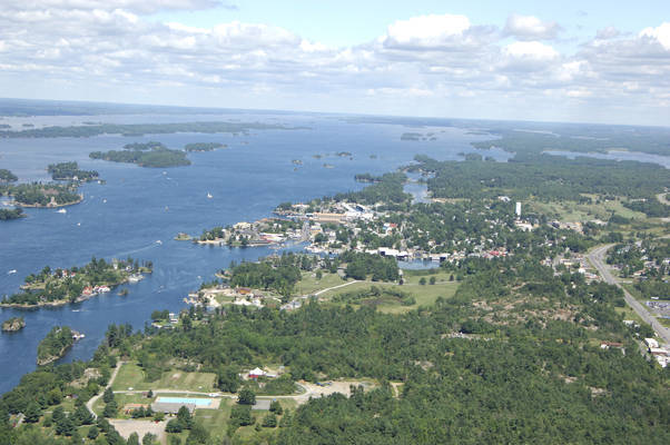
Alexandria Bay
Alexandria Bay, New York United States
Marinas near Alexandria Bay
| Name | Reviews | Max LOA | VHF | Dock Depth | Gas / Diesel | Lift / Crane | Wifi | Amps |
|---|---|---|---|---|---|---|---|---|
| Bonnie Castle Marina | - | - | - | - | G$4.799/galD$4.479/gal | LYes | - | |
| Ledges Resort Motel & Boatel | - | 0.0 m | - | Low 0.0 mHigh 0.0' | - | - | - | - |
| The Riveredge Resort Hotel | - | - | - | - | - | - | - | |
| Hutchinson's Boat Works | - | 0.0' | - | Low 0.0 mHigh 0.0' | GYesDYes | LYes | - | |
| Boldt Castle | - | - | - | - | - | - | - | - |
| Carnegie Bay Marina | - | - | - | - | - | - | - | - |
| O'Briens Boats | - | 0.0 m | - | Low 0.0 mHigh 0.0 m | - | - | - | - |
| Board Walk Resort | - | 0.0 m | - | Low 0.0'High 0.0 m | - | - | - | - |
| AquaMania | - | 0.0 m | - | Low 0.0 mHigh 0.0 m | GYes | - | - | - |
| Rogers Marina Inc | - | - | - | - | - | - | - | - |
| Horizon Marina | - | - | - | - | - | - | - | |
| Alexandria Bay Municipal Dock | - | - | - | - | - | - | - | - |
| Edgewood Resort Marina | - | - | - | - | - | - | - | - |
| Riverwatch Yacht Club | - | 0.0 m | - | Low 0.0 mHigh 0.0' | - | - | - | - |
| Thousand Islands Club | 110.0' | 78 | Low 10.0' | G$4.49/galD$4.19/gal | - | - |
Introduction:
The quiet summer resort town of Alexandria Bay is located off the Saint Lawrence Seaway about 30 miles northeast of Cape Vincent and 28 miles southwest of Ogdensburg. Primarily a summer resort, Alexandria Bay is one of the best equipped harbors on the lower Saint Lawrence Seaway with seven marinas that all cater to transient guests.
Visitors here enjoy fishing, thundering powerboat races, local historic attractions and relatively cool summer temperatures. Ashiore is an antique boat museum, the Thousand Island Park Museum, three art galleries and multiple public parks that are open to hiking and camping.
History:
A gentleman named Cadwaller Child proposed a port at the location where Alexandria Bay now stands in 1804. It was not until 14 years later, however, in 1818, that one Edmund Tucker laid out a village plat, and the owner of the land built a pub and town general store.
In 1878, the village was incorporated and a census was conducted that showed the population to be 638 residents. Larger tracts of land were laid out and surveyed and the original bounds of the town were declared.
Navigating the Water:
Use NOAA Charts 14772 and 14773 and Canadian Hydrographic Services Chart 1436.
The primary harbor in Alexandria Bay is reached via an approach from the north between Cherry and Casino Islands at American Narrows, while a second yachting area is located about a half-mile east. There are seven marinas in the Alexandria Bay area, and all of them accommodate transient guests because of the highly seasonal nature of the boating season here. Repairs can be undertaken in the eastern harbor where a large repair yard maintains a 100-ton lift for haul-outs.
If you are arriving from the east, you will first want to clear green can 33, which marks a 13-foot deep ledge at Broadway Shoal. Once you have safely cleared the shoal, proceed west about a quarter-mile past Casino Island, and then gradually turn into the harbor, making sure avoid the unmarked 11-foot-deep shoal just west of the island.
On approach from the west from American Narrows, set a course for flashing red 194, which marks six-foot-deep Pullman Shoal near Dewey Island. As you get closer to Cherry Island, change your course to find flashing green 195 to the south, and then proceed a little farther east until you are clear to head into the harbor. Two tall blue water towers ashore make for excellent landmarks.
The second yachting harbor in Alexandria Bay is located east of Casino Island. From the Saint Lawrence Seaway, you will chart a course for green can 33 at Broadway Shoal, and then head into the more industrial looking area, which is where the marinas are.
Local Notices to Mariners:
Local Notices to Mariners are available online from the U.S. Coast Guard.


