


Monterey Harbor
California United States
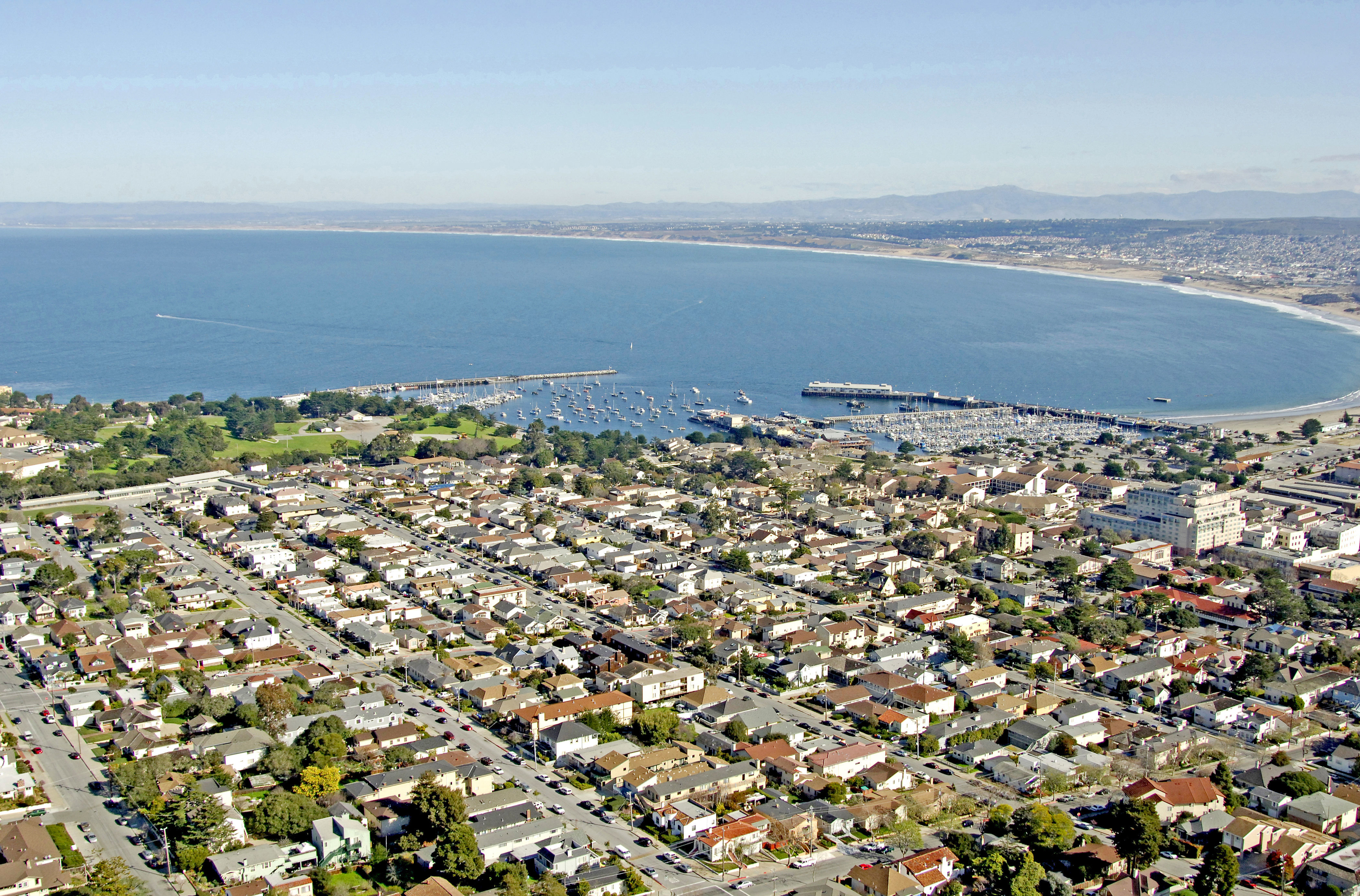
Marinas near Monterey Harbor
| Name | Reviews | Max LOA | VHF | Dock Depth | Gas / Diesel | Lift / Crane | Wifi | Amps |
|---|---|---|---|---|---|---|---|---|
| City of Monterey Harbor | - | - | 5 | - | - | - | - | |
| Monterey Fisherman's Wharf | - | 0.0' | - | Low 0.0 mHigh 0.0' | - | - | - | - |
| Breakwater Cove Marina | - | 0.0' | - | Low 0.0'High 0.0' | - | - | - | - |
| Monterey Peninsula Yacht Club | - | - | - | - | - | - | - | - |
| Monterey Marina | - | - | - | - | - | - | - | - |
| Monterey Bay Boatworks | - | - | 9 | - | - | - | - | - |
| Moss Landing Harbor District | - | - | - | - | - | - | - | - |
| Gravelle's Boat Yard | - | - | - | - | GYesDYes | - | - | - |
| Woodwards Marine | - | 0.0' | - | Low 0.0'High 0.0' | - | - | - | - |
| Elkhorn Yacht Club | - | 0.0' | - | Low 0.0'High 0.0' | - | - | - | - |
| Soquel Cove Mooring | - | 0.0 m | - | Low 0.0 mHigh 0.0' | - | - | - | - |
| Capitola Boat and Bait | - | - | - | - | - | - | - | - |
| Santa Cruz Harbor Fuel Dock | - | - | - | - | GYesDYes | - | - | - |
| Santa Cruz Harbor | - | - | - | - | - | - | - | - |
| Santa Cruz Yacht Club | - | - | - | - | - | - | - | - |
Introduction:
One of the most beautiful stretches of coast in the world; the Monterey Peninsula pushes itself out in to the aqua-teal waters of the Pacific Ocean to form the southern cradle of Monterey Bay an area of rich and diverse marine, mammal and bird life. Endangered Pacific sea otters wrap themselves in the beds of kelp just off the shore while seals and porpoises are frequent visitors to the waters here.
Home to Pebble Beach Golf Club, the Monterey Bay Aquarium, Cannery Row, Carmel, Pacific Grove and close to the beautiful Big Sur coastline, this area begs exploration and further investigation.
History:
Long before Europeans arrived, native peoples of the Esselen, Ohlone and Salinan tribes flourished here. Ancestors of the Esselen Indians are believed to be the first inhabitants. Later, tribes from the east joined with the Esselen Indians to become the Ohlone; they relied on the abundance of the sea and thrived. Further south, the Salinan Indians lived.
Sebastian Vizcaino was the first European to set foot on the Peninsula, on December 19, 1602. He called it "Monterey" after Count de Monte Rey, a viceroy of New Spain. He named the valley for his patron saint, Our Lady of Carmel. Though Vizcaino urged the Spanish to colonize the area, it took a century and a half before they proceeded to settle Alta (or Upper) California.
The Monterey Peninsula also called to people who sought respite from the hectic of life of the cities. In 1875, Pacific Grove was settled as a religious retreat, and by the mid-1880s, 17,000 visitors a year were enjoying the beauty and serenity of the Peninsula, often staying at the elegant Hotel Del Monte. The Del Monte Golf Course opened in 1897 and by 1908 guests could enjoy a 17-mile tour through the Del Monte Forest and along the coast. That dirt road became 17-Mile Drive.
The 1930s saw an influx of Midwestern farm refugees seeking sanctuary from the ravages of drought. Their farms devastated by dust storms, the migrants clung to the hope that California's mild climate, longer growing seasons, and diversity of crops would give them an opportunity to start over. Dreams turned to despair when the migrants found that California was suffering hard times as well. Conflicts arose between the refugees and earlier immigrants who had already settled in Monterey County. Still, those migrants made a significant contribution to the area; they helped to create what is now known as the "Salad Bowl of the Nation." To an already diverse mix of Mexicans, Filipinos, Chinese, Japanese, Portugese, Italians and Europeans, these mainly predominantly Anglo-Americans added their culture. The story of their struggles inspired John Steinbeck to pen one of the classics of American literature, The Grapes of Wrath.
[i]Information Courtesy County of Monterey County[/i]
Navigating the Water:
Use NOAA Charts 18686 and 18685
Winds on the Monterey Coast can getshall we sayadventurous at times, especially during the winter months. The enclosed man-made harbor area is fairly well-protected, but is open to the norththe predominant winter-pattern wind direction.
Approach from the north. Point Pinos Light, standing 89 feet about the Pacific helps guide you in toward flashing red 2 and a series of private white buoys that move you in toward flashing red 6 at the north breakwall of Monterey Harbor. Depths are good here, but the area is open to the north.
Local Notices to Mariners:
Local Notices to Mariners are available online from the U.S. Coast Guard.
Things To Do/Local Events:
The Monterey Bay Aquarium is one of the largest attractions in Monterey, and rightly so. With over 200 award-winning displays and galleries, including the 343,000-gallon Kelp Forest Exhibit, an entire day can be spent wandering and taking in the scenes. See the Helpful Links section below for more information and aquarium hours.
If you plan to stay in the Monterey area for a couple of days, it is well worth the cost of a rental to gain full access to all the areas rich attractions. Seventeen Mile Drive is a popular way to gain access to the coastline along Pebble Beach and a small admission fee is required to drive the route. Farther to the south is rugged and beautiful U.S. Highway 1, which travels 26 miles south to Big Sur Station and the beautiful redwood forests of the coast. Whatever you do, dont find yourself absent a camera.
The legendary Monterey Jazzfest is held here every year in September.
Transportation:
See the Transportation link in the Helpful Links section below.