Sheephead Cut Inlet
| New Smyrna Beach, Florida United States | |
| 29° 2' 2.4'', -80° 54' 21.24'' | |
| New Smyrna Beach |
You might also consider...


About
Introduction:
Located south of Ponce de Leon Inlet and just east of New Smyrna Beach-proper, Sheephead Cut is a shoal-draft alternative to the Intracoastal Waterway, which runs past Chicken Island just north of Sheephead Cut.
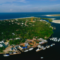
The image above is a view from the east looking west over Sheephead Cut toward the town of New Smyrna Beach with the 65-foot fixed vertical clearance Harris Saxon Bridge in the background. To the right (north) is Chicken Island, where, on its north side, the ICW route runs. Also visible above are the first set of daybeacons into Sheephead Cut on its east side: Green daybeacon 1, red daybeacon 2, green daybeacon 3, and red daybeacon 4.
Navigating the Water:
Use NOAA Chart 11485. .
Depths in the cut range from nine to 15 feet, and it is sometimes the more popular route for boaters transiting the ICW. There have been reports of shallow six-foot-deep spots along Sheephead Cut, though, and some have advised a call ahead for advance local knowledge from one of the local marinas before giving it a go.
Approaching from the east, the first two marks into the cut are green daybeacon 1 and red daybeacon 2 at the east side of Chicken Island. Once you have cleared green daybeacon 1 and red daybeacon 2, continue the passage west and pick up green daybeacon 3 and red daybeacon 4 farther on. Red daybeacon 6, green daybeacon 7, and red daybeacon 8 lead you all the way west to the point where Sheephead Cut joins the ICW route east of the New Smyrna waterfront.
There is anchorage available south of the Harris Saxon Bridge in two side channels off the ICW route, and several good marinas line up on the west side of the route, many of which have transient facilities.
Local Notices to Mariners:
Local Notices to Mariners are available online from the U.S. Coast Guard.


