


Hernando Beach Harbor
Hernando Beach/Spring Hill, Florida United States
Marinas near Hernando Beach Harbor
| Name | Reviews | Max LOA | VHF | Dock Depth | Gas / Diesel | Lift / Crane | Wifi | Amps |
|---|---|---|---|---|---|---|---|---|
| Suncoast Marina | - | 0.0' | - | Low 0.0 mHigh 0.0' | - | - | - | - |
| Blue Pelican Marina | - | - | - | - | - | - | - | |
| Adventure Coast Marina | - | - | - | - | - | - | - | |
| Sterling Marina | 0.0' | - | Low 0.0 mHigh 0.0' | - | - | - | - | |
| Gulfstar Marine | - | 0.0 m | - | Low 0.0 mHigh 0.0 m | - | - | - | - |
| Hernando Beach Yacht Club | - | - | - | - | GNearby | - | - | - |
| Nature Coast Marina | - | - | - | - | GNearbyDNearby | LYesCNearby | - | - |
| Hernando Beach Marina | - | - | - | G$4.00/galD$3.75/gal | LYesCYes | - | ||
| Weeki Wachee Marina | - | - | - | - | - | - | - | - |
| Port Hudson Marina | 0.0' | - | Low 0.0 mHigh 0.0' | GYesDYes | - | - | - | |
| Hudson Beach Marina | - | 0.0 m | - | Low 0.0 mHigh 7.0' | - | - | - | - |
| Skeleton Key Marina | - | 0.0' | 16 | Low 0.0 mHigh 0.0' | GYes | - | - | - |
| Sea Ranch Marina | - | - | - | - | - | - | - | |
| Sunset Landing Marina | - | - | - | - | - | - | - | - |
| American Marina | - | 0.0' | - | Low 0.0 mHigh 0.0' | - | - | - | - |
Introduction:
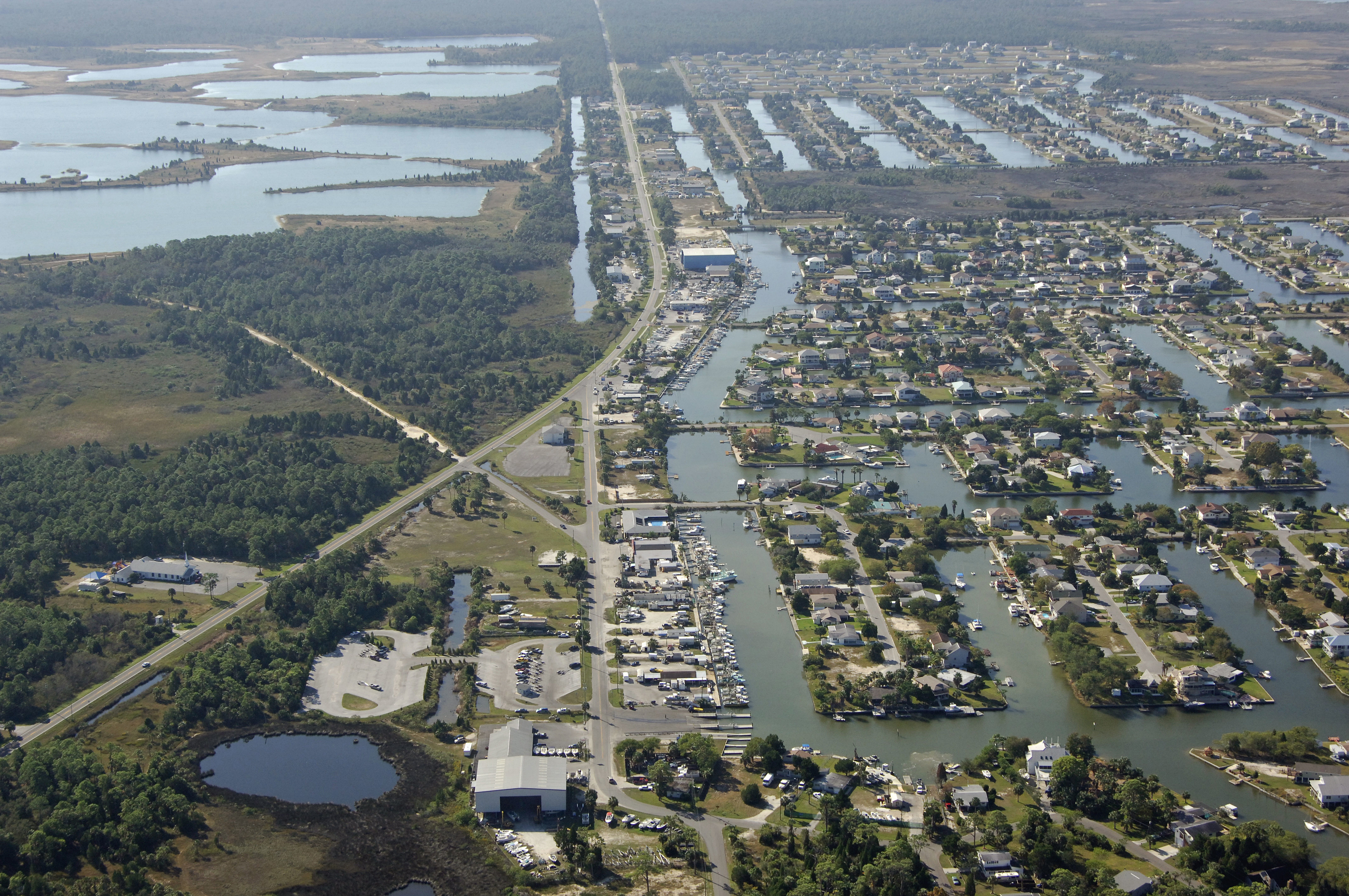
The image above is a view from the west looking east over the twisting canals of the Hernando Beach area. The dredged entry channel is visible as it enters the image above from the lower left (west) and proceeds east in toward Minnow Creek. Hernando Beach is a decent stopover for cruisers traveling north and south along the Gulf Intracoastal Waterway that want to rest for the night in relative protection.
Hernando Beach is a quiet and fairly remote town, but there are a couple of marinas inside Minnow Creek that can assist traveling mariners with a tie-up for the evening and a small marine repair shop is located ashore. Technically, most of the marine shops and marinas are located within the ZIP code that encompasses Spring Hill, which is located right within Hernando Beach.
Navigating the Water:
Use NOAA Chart 11409.
Hernando Beach is approached from the Gulf of Mexico via a passage from the northwest across the flats of the surrounding waters that eventually runs into Minnow Creek at Hernando Beach. Boats with drafts of more than four feet need not apply; the waters here are shallow.
The actual approach to Hernando Beach begins slightly northwest of the town, although local boats will often forego the formal entrance and proceed directly in to Coon Key Point. The recommended procedure is to first set a course to arrive in the area of waypoint 28 31.092N 82 42.216W, which should place you near green daybeacon 1 and red daybeacon 2 at the beginning of the channel. Once you have picked up these markers strictly follow the other aids to navigation until you reach green daybeacon 13.
Once you have arrived at green daybeacon 13, set a course of about 162 degrees magnetic so pick up the dredged channel on the and of Cedar Key Point. From here, follow the length of small aids to navigation in, minding the depth sounder and proceeding slowly through the narrow channel.
Local Notices to Mariners:
See our Local Notices to Mariners blog for updates on the latest conditions and advisories for this area.
Things To Do/Local Events:
See our Helpful Links section below for a detailed calendar of events for the area.
Transportation:
Hernando Beach is pretty remote, and the nearest major airport is Orlando International, which is located about 80 miles to theeast-northeast. Your only real way of getting to and from the airport will be to rent a vehicle at the airport or in Hernando itself if you need to pick up crew or disembark from your boat.