


Moore Haven Harbor
Moore Haven, Florida United States
Marinas near Moore Haven Harbor
| Name | Reviews | Max LOA | VHF | Dock Depth | Gas / Diesel | Lift / Crane | Wifi | Amps |
|---|---|---|---|---|---|---|---|---|
| Moore Haven Marina | - | 100.0' | - | Low 0.0 mHigh 0.0' | - | - | - | 30, 50 |
| Moore Haven Dock | - | - | - | - | - | - | - | - |
| River House Marina | 100.0' | - | Low 7.0' | - | - | 30 & 50 | ||
| The Glades RV Resort, Golf & Marina | - | - | - | - | - | - | - | |
| Glades Boat Storage | - | - | - | - | - | LYes | - | - |
| Angler's Marina | - | - | - | - | - | - | - | |
| Roland Martin's Marina | 125.0' | 16 | - | G$5.98/galD$5.99/gal | - | - | ||
| Jolly Roger Marina | - | 0.0' | - | Low 0.0 mHigh 0.0' | - | - | - | - |
| River Forest Yachting Center - Moore Haven | - | - | - | - | - | - | - | |
| Port LaBelle Marina | 0.0' | 16 | Low 0.0 mHigh 0.0' | G$6.169/galDYes | - | - | ||
| Belle Hatchee Marina | 0.0 m | - | Low 0.0 mHigh 0.0' | - | - | - | - | |
| LaBelle City Dock | 80.0' | - | - | - | - | - | - | |
| Labelle Yacht Club | 125.0' | - | Low 8.0'High 0.0' | - | - | - | ||
| The Launch | - | - | - | - | - | - | - | - |
| Okee-Tantie Campground & Marina | - | 0.0 m | - | Low 0.0 mHigh 0.0 m | - | - | - | - |
Introduction:
Located 12 miles northwest of Clewiston, Moore Haven is a popular stop among cruiser transiting the Okeechobee Waterway westbound, as the next town with supplies is La Belle some 22 miles to the west near Mile Marker 103.
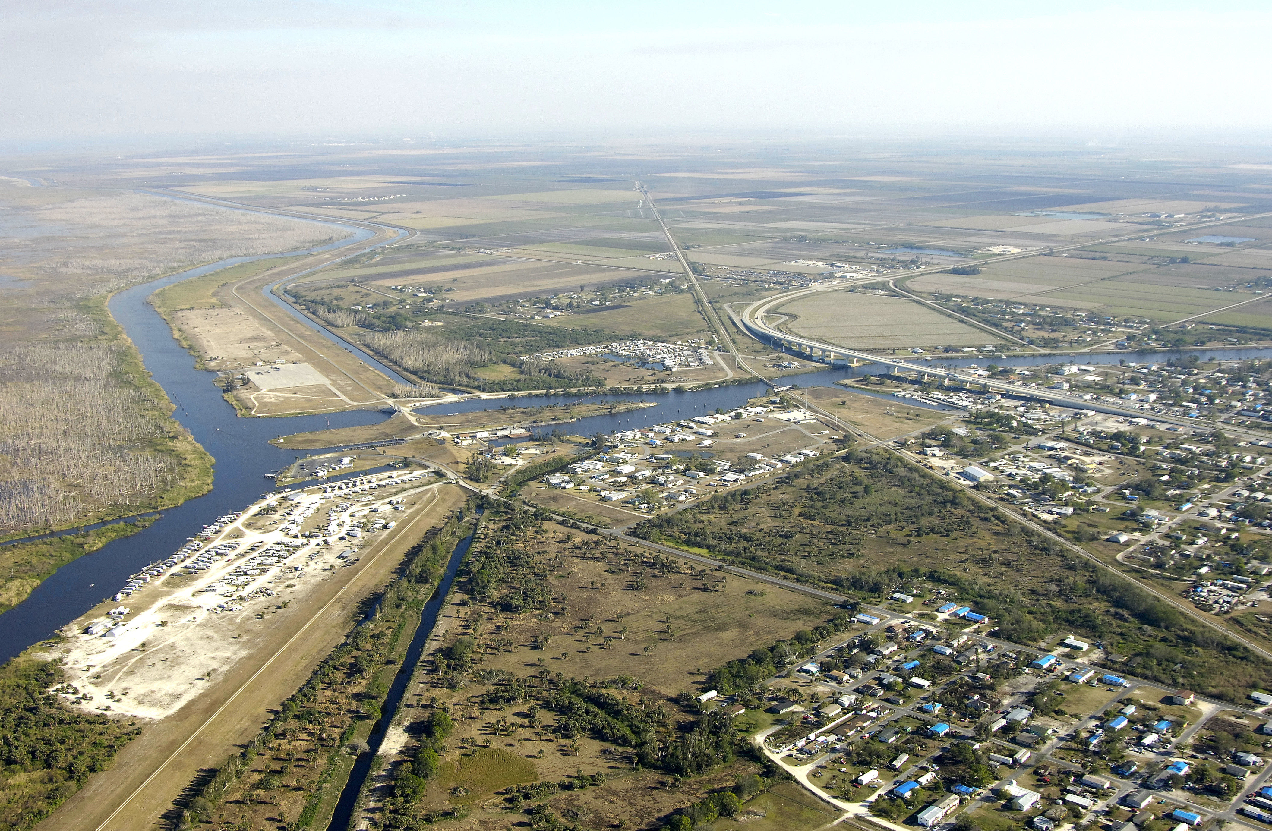
The image above is a view from the north looking south over the Moore Haven Lock (Mile 78.0), which has a width of 50 feet and a length of 250 feet. Farther south are two bridges, one railroad swing and one twin fixed. The channel is usually called the Caloosahatchee Canal from this point west to Fort Meyers.
Navigating the Water:
Use NOAA Chart 11428.
After you have cleared the lock, a railroad swing bridge (five-foot closed vertical clearance, usually open unless rail traffic is approaching) and a twin fixed bridge (55-foot fixed vertical clearance) cross the route, posing few problems for recreational boaters.
The city of Moore Haven has provided a dock for cruising boaters, but the rule here is first-come, first served. Also, reports indicated that it has fallen into a slight state of disrepair. use your judgement when coming alongside to tie up. Lamasters Marina is the only commercial dockage venture here, and they do have gas and diesel fuel for those who need to fill up before heading to La Belle or Clewiston. Ashore is a post office, liquors store and grocery store for provisioning.
Local Notices to Mariners:
See our Local Notices to Mariners blog for updates on the latest conditions and advisories for this area.