


Seal Harbor
Mount Desert Island, Maine United States
Marinas near Seal Harbor
| Name | Reviews | Max LOA | VHF | Dock Depth | Gas / Diesel | Lift / Crane | Wifi | Amps |
|---|---|---|---|---|---|---|---|---|
| Seal Harbor Town Wharf | - | - | - | - | - | - | - | - |
| Seal Harbor Yacht Club | - | - | - | - | - | - | - | |
| Harbor Club | - | - | - | - | - | - | - | - |
| Cranberry Isles Fishermens Co-Op | - | - | - | - | - | - | - | - |
| Islesford Dock | - | - | - | - | - | - | - | - |
| Clifton Dock | - | 0.0' | - | Low 0.0'High 0.0' | GYesDYes | - | - | - |
| Spurling Cove Town Dock | - | 0.0 m | - | Low 0.0 mHigh 0.0' | - | - | - | - |
| Mt. Desert Harbormaster | - | - | - | - | - | - | - | - |
| Northeast Harbor Town Dock | - | 0.0' | 68 | Low 0.0 mHigh 0.0' | GNearbyDNearby | LNearby | 30,50,100 | |
| Northeast Harbor Marina | - | 180.0' | 68 | Low 12.0'High 0.0' | - | - | 30, 50, 100 | |
| Hinckley Yacht Services - Northeast Harbor | 80.0' | 10 | - | - | LYes | - | - | |
| Cranberry Island Boat Yard | - | 0.0 m | - | Low 0.0'High 0.0' | - | - | - | - |
| Newman and Gray Boatyard | - | 0.0 m | - | Low 0.0 mHigh 0.0' | - | - | - | - |
| Hinckley Yacht Services - Southwest Harbor | - | 10 | - | D$5.95/gal | LYes | - | ||
| Manset Yacht Service | - | 0.0 m | - | Low 0.0 mHigh 0.0' | - | - | - | - |
Introduction:
Seal Harbor is located on the southeastern part of Mount Desert Island close to Acadia National Park. Seal Harbor, which is a part of the Mount Desert area, covers 25,699 acres and has an approximate population of 2,109. There are often many sailing and other vessels anchored in Seal Harbor and with peaceful views of the harbor, the eccentric village has become a prime summering place for thousands of visitors during the busy summer season.
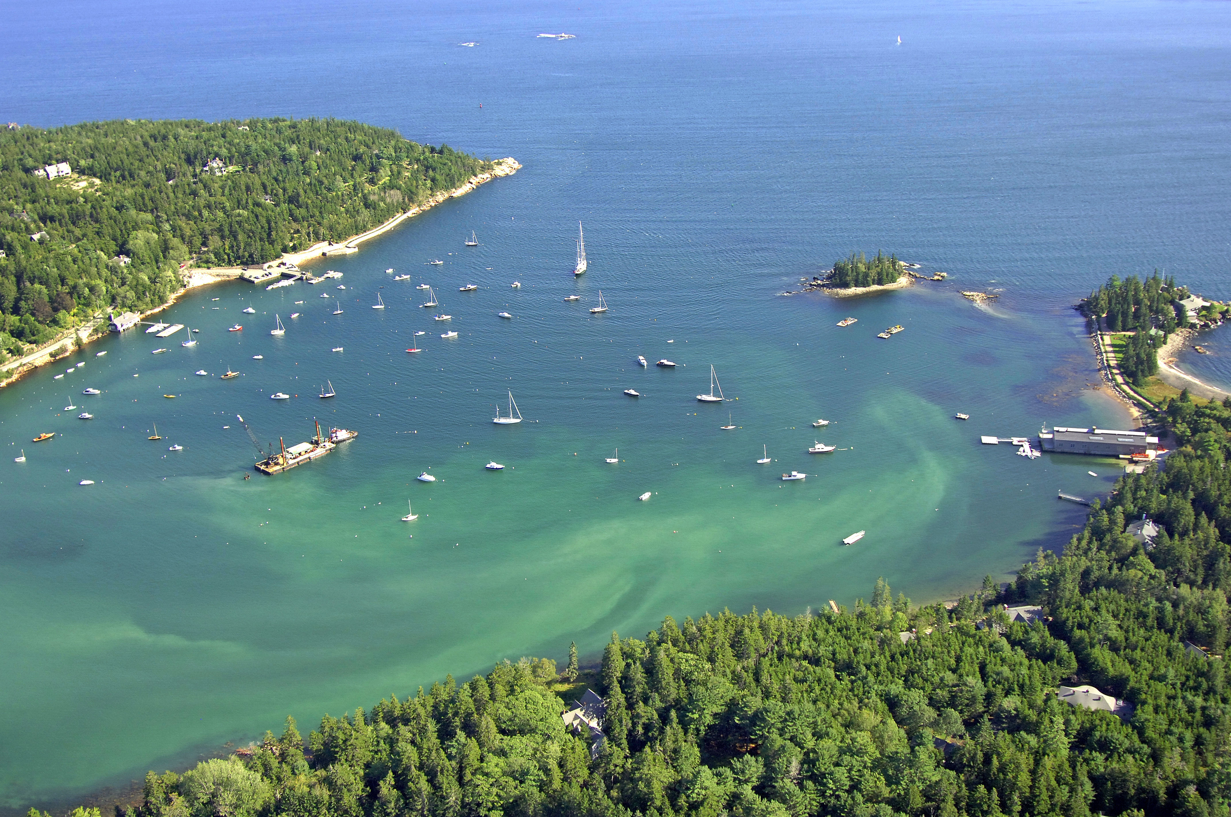
The image above is a view from the south looking north over Seal Harbor where it meets Eastern Way northeast of Sutton Island. The small forested island on the left (west) side of the image is the southeastern edge of Crowninshield Point, while East Point is visible to the center right (east).
There are two marina facilities in Seal Harbor, but neither has dock tie-ups available. Seal Harbor Yacht Club may have slips available to members of reciprocating yacht clubs, but be sure to call ahead. Moorings are administered by the Seal Harbor Town Wharf. If you decide to hang out on a mooring or anchor out in Seal Harbor, be prepared with sufficient supplies; there are no facilities nearby ashore.
Navigating the Water:
Use NOAA Chart 13313.
Seal Harbor is approached from the south via a passage through Eastern Way where it meets Frenchmans Bay. There are two passages into Eastern Way: One to the south of East Bunker Ledage and Lewis Rock, and one to the south. While the one to the north is the most direct route, it may not always be advisable in fog or low-visibility conditions. We will discuss both routes here.
[b]North Approach:[/b]
From the lower portion of Frenchmans Bay, first set a course for green can buoy 3A, which marks nasty, six-foot-deep Lewis Rock. If you are coming in at night, you can alternatively set a course for flashing red buoy 4 just south of East Point. Past flashing red buoy 4,set a course for green can buoy 1, which is southeast of Crowninshield Point, and also visible in the image above for those with a sharp eye (use our zoom feature). From here you can head into the harbor where you will find 11- to 14-foot depths over a sand/rock bottom.
[b]South Approach:[/b]
First set a course for flashing red buoy 2, which is just south of East Bunker Ledge near waypoint N44 16.533 W68 13.035. After you have reached flashing red buoy 2, continue to head west for about .6 miles, and then head north to intercept aforementioned green can buoy 1 at the entrance to Seal Harbor.
Local Notices to Mariners:
Local Notices to Mariners are available online from the U.S. Coast Guard.
Transportation:
Like most of the outlying harbors and coves on Mount Desert Island, Seal Harbor is remote, and the only way to get around is by bike or on foot. Much like the rest of Mount Desert Island, you will have to be fairly self-sufficient to get around efficiently.