


Tenants Harbor
Tenats Harbor, Maine United States
Marinas near Tenants Harbor
| Name | Reviews | Max LOA | VHF | Dock Depth | Gas / Diesel | Lift / Crane | Wifi | Amps |
|---|---|---|---|---|---|---|---|---|
| Art's Lobsters | - | 0.0 m | - | Low 0.0 mHigh 0.0' | - | - | - | - |
| Tenants Harbor Boatyard | 100.0' | 9 | Low 10.0' | G$6.50/galD$5.10/gal | CYes | 30/50 | ||
| Chandlery | - | - | - | - | - | - | - | - |
| Luke's at Tenants Harbor | - | - | - | - | - | - | - | - |
| Tenants Harbor Town Dock | - | 0.0' | 11 | Low 0.0'High 0.0' | - | - | - | - |
| Port Clyde Moorings by Lyman-Morse | 50.0' | 9 | Low 15.0' | G$6.52/galD$5.35/gal | - | - | ||
| Port Clyde Town Dock | - | 0.0 m | - | Low 0.0 mHigh 0.0' | - | - | - | - |
| Merchants Landing Moorings | - | - | - | - | - | - | - | - |
| Spruce Head Marine | - | 0.0' | - | Low 0.0 mHigh 0.0' | - | LYes | - | - |
| Jeff's Marine Service | - | - | - | - | - | - | - | - |
| Lyman-Morse Boatbuilding | - | 0.0 m | 16 | Low 0.0 mHigh 0.0' | - | - | - | - |
| Thomaston Town Dock | - | 0.0 m | - | Low 0.0'High 0.0' | - | - | - | - |
| Thomaston Town Landing | - | 0.0' | - | Low 0.0'High 0.0' | - | - | - | - |
| Harbor View Tavern & Marina | - | 0.0 m | - | Low 0.0'High 0.0' | - | - | - | - |
| Sail Power & Steam Museum | - | - | - | - | - | - | - | - |
Transportation:
Like most of the outlying harbors and coves, Tenants Harbor is remote, and the best way to get around is by bike or on foot. Like much of the Maine Coast, you will have to be fairly self-sufficient to get around efficiently.
Navigating the Water:
Use NOAA Chart 13301.
Tenants Harbor is reached via an approach from the east through the Atlantic Ocean south of Long Cove and Clark Island. Approaching from the east or south, first set a course for flashing green buoy 1, which is located at an approximate waypoint of N43 57.693 W69 10.879. Once you have safely navigated to flashing green buoy 1, pass it decidedly to port, and then head west into the harbor area.
Note: If you are approaching from the east, make sure to mind red nun buoy 2SB, which marks a rock ledge south of Whitehead Island and farther on to the west, green nun buoy 1. If you are approaching from the south, be sure to keep an eye out for green nun buoy 1, which marks the location of Hart Ledge, about one mile south of Southern Island.
Local Notices to Mariners:
Local Notices to Mariners are available online from the U.S. Coast Guard.
Introduction:
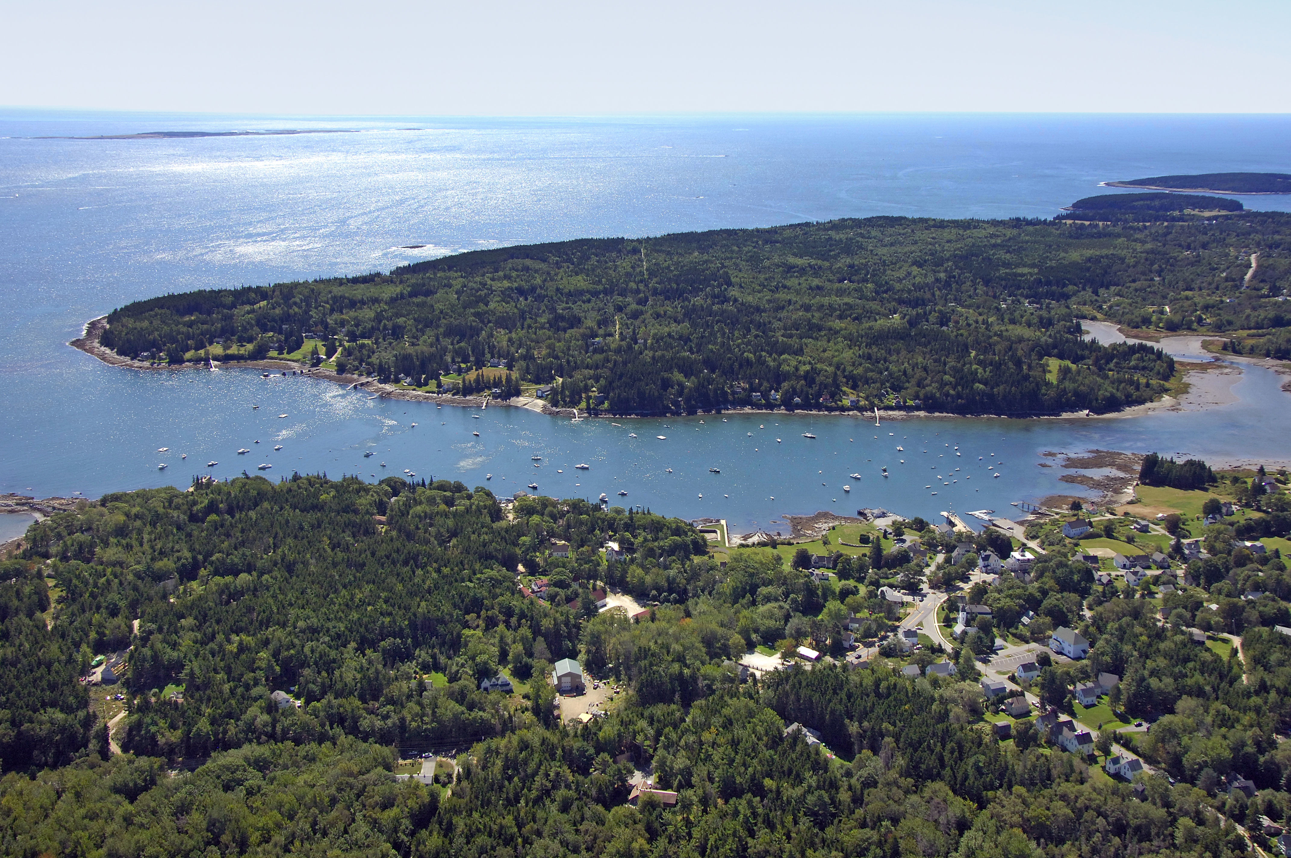
Tenants Harbor is located east of the St. George River just north of Hart Neck and south of Long Cove. Geographically speaking, Tenants Harbor is 17 miles southwest of Vinalhaven Island and 59 miles northeast of Portland.
The image above is a view from the east looking west over the opening to Tenants Harbor where it empties into the Atlantic Ocean. Off to the left (south) is Hart Neck, while the fringes of a rock ledge near the passage north to Long Cove can be seen off to center right. Off in the distance on the horizon, the St. George River can be seen working its way north toward the town of Thomaston.
As of this writing the town of Tenants Harbor reports that there is no anchoring allowed in the town harbor. If you want to drop the hook, you can do so outside of the mooring fields, or head up into Long Cove, which is just north of red nun buoy 2 on the approach. There are no real transient slips in town, but you can fill up with both gas and diesel fuel at Cod End Market. Tenants Harbor Town Dock administers the moorings in the harbor.
Things To Do/Local Events:
There are lots of activities available in and around Tenants Harbor, from hiking, biking and kayaking to golf, shopping and sightseeing. Visiting mariners will find shops, art galleries and good eateries in town, with many more options available in the nearby towns of Rockland or Thomaston. Rockland is home to the annual Maine Lobster Festival in August, as well as the Wyeth Center and Farnsworth Art Museum.