


Old Harbor
Block Island, Rhode Island United States
Marinas near Old Harbor
| Name | Reviews | Max LOA | VHF | Dock Depth | Gas / Diesel | Lift / Crane | Wifi | Amps |
|---|---|---|---|---|---|---|---|---|
| Old Harbor Dock Town of New Shoreham | - | 0.0' | 12 | Low 0.0 mHigh 0.0' | - | - | - | |
| Ballard's Marina | 120.0' | 10 | Low 10.0' | - | - | - | - | |
| Twin Maples Bait & Tackle | - | 0.0 m | - | Low 0.0 mHigh 0.0' | - | - | - | - |
| Smuggler's Cove Marina | - | 0.0 m | - | Low 0.0 mHigh 0.0 m | - | - | - | - |
| Payne's Dock and Mahogany Shoals | 300.0' | - | Low 0.0 mHigh 0.0' | GYesDYes | - | - | - | |
| New Harbor Boat Basin | 110.0' | 9 | Low 10.0'High 0.0' | - | - | - | 30, 50 | |
| Town of New Shoreham | - | 12 | High 22.0' | - | - | - | - | |
| Champlin's Marina and Resort | - | 11 | Low 20.0' | G$6.09/galD$6.59/gal | - | 30/50 | ||
| Shelter Cove Marina | - | - | - | - | - | - | - | - |
| Skip's Dock | - | 0.0 m | - | Low 0.0 mHigh 0.0' | - | - | - | - |
| Jim's Dock, Inc | - | 0.0 m | - | Low 0.0 mHigh 0.0' | - | - | - | - |
| State Pier | - | - | - | - | - | - | - | - |
| Point Judith Fisherman's Club | - | - | - | - | - | - | - | - |
| Rhode Island State Pier | - | 0.0 m | - | Low 0.0 mHigh 0.0' | - | - | - | - |
| Rhode Island Engine Club | - | - | - | - | DYes | - | - | - |
Local Notices to Mariners:
Local Notices to Mariners are available online from the U.S. Coast Guard.
Introduction:
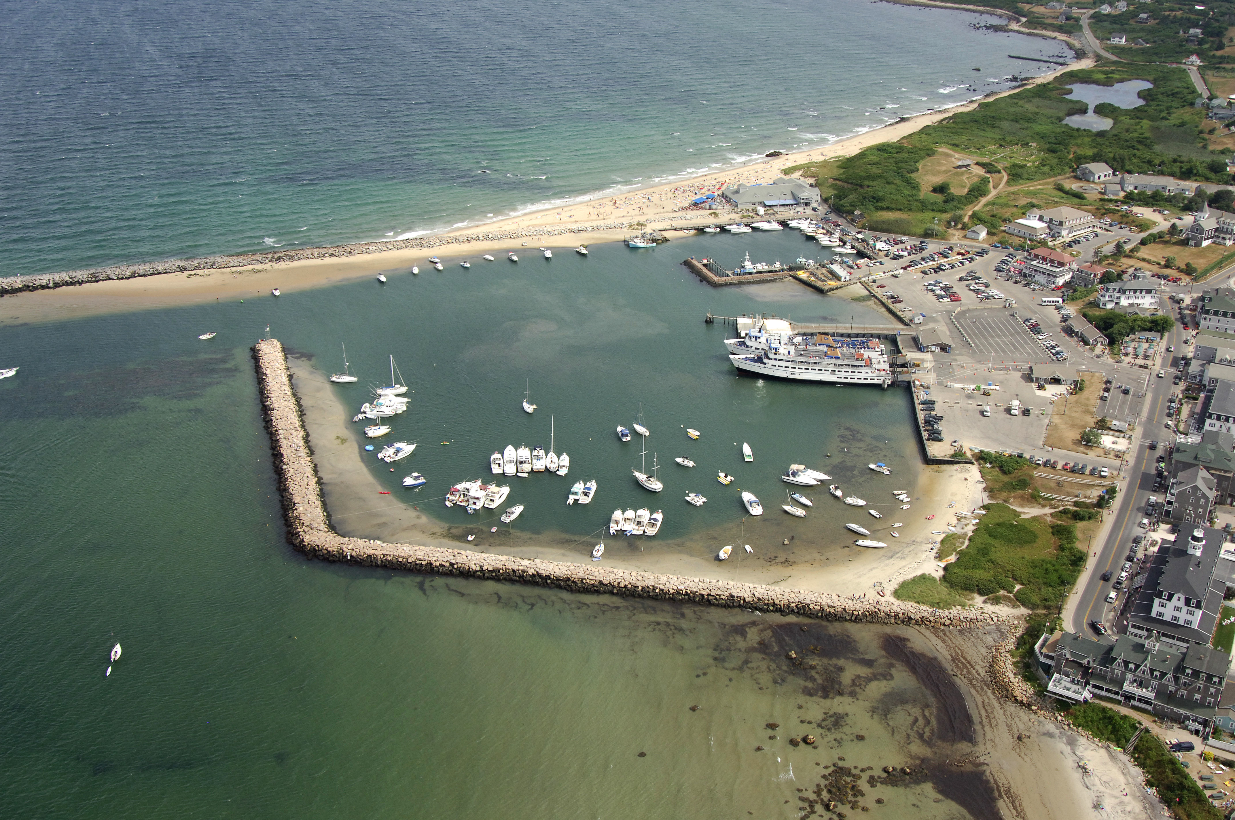
Old Harbor is a man-made yacht basin located on the east side of Block Island, almost geographically opposite from Great Salt Pond, which is on the west side of the island. Old Harbor is the main landing point for the mainland ferries that run on regular schedules to the island, but there is also a marina with space here and limited mooring facilities, too. Anchoring is prohibited due to the ferry traffic that comes and goes at all hours.
Inside of the Old Harbor breakwaters is a singe marina on the far side of the small harbor that has facilities and slips available to transient guests. Moorings are available to starboard on entry, and there are several points for landing your dinghy around the harbors edge (be sure to lock and chain your dinghy here).
Navigating the Water:
Use NOAA Chart 13215.
From the east side of Block Island, set a course for flashing green 3 at the east breakwater to Old Harbor. Once you have sighted this light, you will see green can 5, and then red nun 6 before flashing red light 8 marks the west breakwater to the harbor (shorter than the east breakwater).
The harbor inlet and the harbor itself have depths of 10 to 15 feet, and once you have negotiated the breakwalls, you will see the Old Harbor Marina to port and a small mooring field to starboard. Many people simply beach their dinghies on the sandy beach areas to go ashore.
Local Notices to Mariners:
Aside from sailing, fishing, boating and beach going, there are plenty of activities shoreside on Block Island. There are plenty of Victorian bed and breakfasts, and the shoreside is lined with excellent dining establishments.
Much of the island is a nature preserve, and bird watchers form around the world come here to catch a life bird among the many species that live son the beach and in the meadows ashore. See the Helpful Links section below for a detailed calendar of events.
Transportation:
The only way to get to and from Block Island efficiently is by plane or boat. Daily ferries run from Point Judith, Newport and New London, CT, to Old Harbor throughout the season. Ashore in Porvidence, RI, is the T.F. Green International airport, which offers daily commercial air service. See the Helpful Links section below for more detailed transportation schedules.
Helpful Links:
Block Island Chamber of Commerce