Cayuga Seneca Canal Inlet
| Waterloo, New York United States | |
| 42° 52' 5.16'', -76° 56' 32.99'' | |
| Seneca Falls |
You might also consider...


About
Introduction:
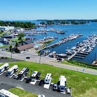
The Cayuga and Seneca Lake Canal runs about 12 miles from Seneca Lake to Cayuga Lake in Upstate New York about 40 miles southeast of Rochester and 38 miles southwest of Syracuse. The waterway connects the Erie Canal with upstate New Yorks Finger Lake Region. Pictured above is the canals southern terminus at the northern end of Seneca Lake.
Navigating the Water:
Use NOAA Chart 14786.
The Cayuga and Seneca Canal empties into Seneca Lake south of Seneca Lake State Park in the upper northwest portion of the lake. At the terminus of the canal is a busy mix of marinas and five fixed bridges within a one-mile stretch. The minimum vertical clearance of all five bridges is 17 feet.
From Seneca Lake, set a course for flashing green buoy 135 and flashing red buoy 136 about two-tenths of a statute mile from the breakwatered entrance to the canal. Once you have cleared these markers, set your sights on flashing green 133 and flashing red 134 just inside the inlet breakwaters. (These two markers are visible in the image above.) Having cleared the inlet, you need only stay in the middle of the canal for the rest of your journey, but be aware that five fixed bridges (minimum 17-foot vertical clearances) cross the water just ahead. Locks and flood gates follow on your way to the Erie Canal.
Inside the protected inlet are three marinas. Two of the marinas have limited transient slips (one a yacht club with reciprocal privileges) and the other is the Seneca Lake State Park Marina (to the left in the image above), which makes as many transient slips as possible available for visiting mariners.
Local Notices to Mariners:
Local Notices to Mariners are available online from the U.S. Coast Guard.


