Broad Creek Inlet
| Deltaville, Virginia United States | |
| 37° 33' 57.61'', -76° 18' 50.05'' | |
| Deltaville - Broad Creek |


You might also consider...


About
Introduction:
Broad Creek Inlet is located off of the Rappahannock River near Stingray Point on Virginias Western Shore. Deltaville is an immensely popular stopover point for boater making the northbound or southbound trek on the Chesapeake Bay because of its location about half way between Solomons Island and Norfolk. Deltavilles Broad Creek has a number of marinas on its shores, and a couple of repair yards with full haul-out capabilities. Deltaville is 40 miles
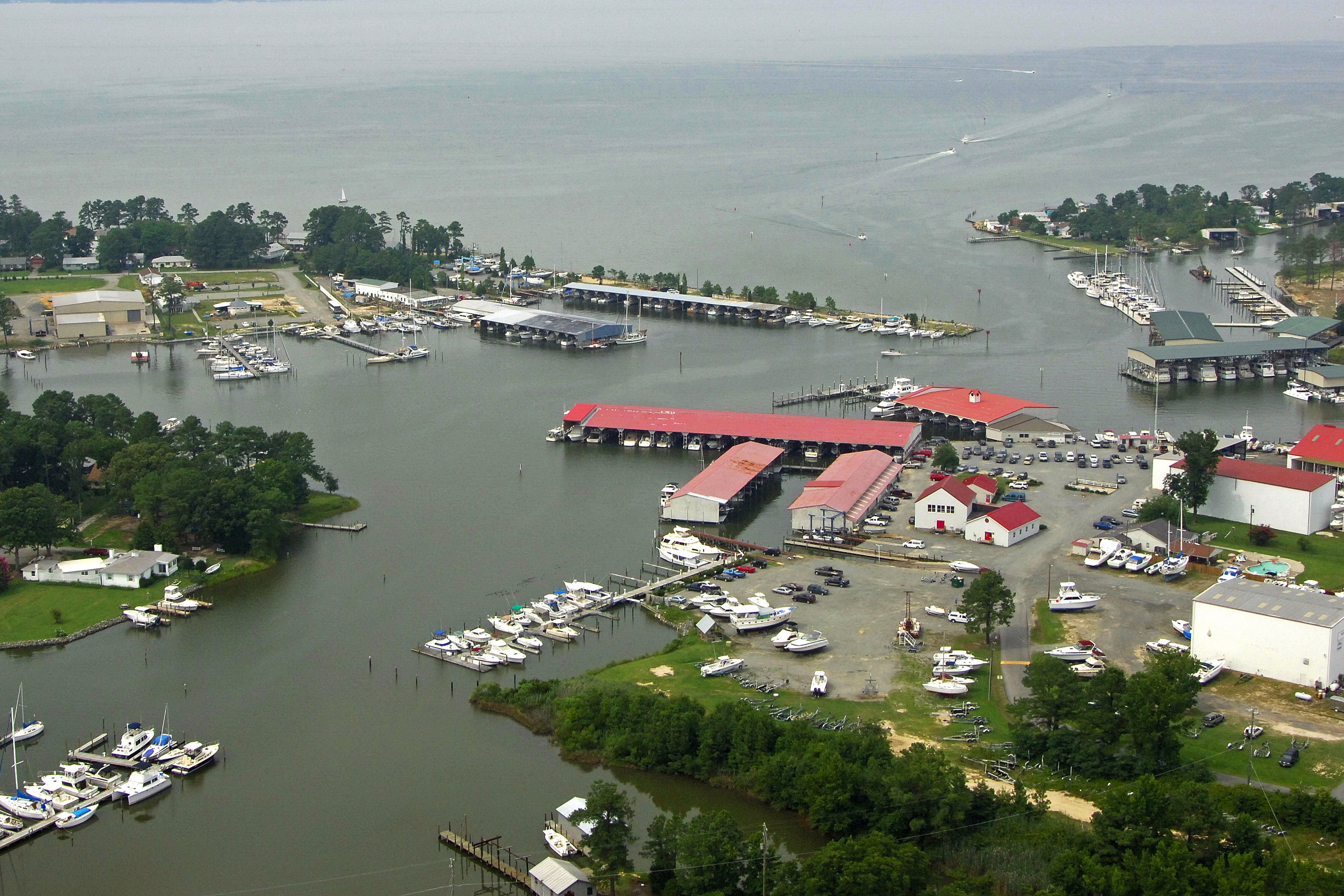
The image above is a view from the north looking south over the Broad Creek entrance channel. Fishing Bay and Stove Point Neck can be seen off in the upper right hand portion of the image, while Gwynn Island can be seen off to the left.
Navigating the Water:
Use NOAA Chart 12235.
From the Chesapeake Bay, be sure to clear the light at Windmill Point (flashing white every six seconds), which is located near waypoint N37 35.819 W76 14.156W. From here, set an approximate course of 257 degrees magnetic to flashing green 1 at the mouth of Broad Creek, about 4.3 miles away.
BROAD CREEK 1 HAS BEEN MOVED
The following change has significant impact to boaters entering or leaving Broad Creek Channel on the Rappahannock River near Deltaville, Virginia.
The entrance mark for Broad Creek Channel was recently moved about 520 feet to the SSW. This effectively makes the marked channel about 520 feet shorter. While the entrance mark originally set in deep water and could be approached on a course parallel to the shore from either upriver or downriver, the new entrance mark is set at the edge of shallow water. If boaters make a sharp turn upriver or downriver at that mark they will encounter shallow water. There is now shallow water immediately downriver of the mark.
When leaving the channel, boaters should continue along the general course of the channel for at least 500 additional feet past the new marker before turning up or down the river. Likewise, boaters entering the channel should stay out in the river 500 or more feet away from the channel entrance mark until they are roughly in-line with the channel before turning toward the entrance mark.
The change was published in the USCG Local Notice to Mariners, District 5, Week 44, 2015 (dated November 3 2015). The specifics are
CHART VA -CHESAPEAKE BAY: RAPPAHANNOCK RIVER ENTRANCE (PIANK & GRT WIC RV). 12235
Change Broad Creek Channel Entrance Light 1 at from 37-34-18.403 N 076-18-28.240 W
to Broad Creek Channel Entrance Light 1BC, Fl G 2.5s, 15FT, 4M , 37-34-13.604 N 076-18-30.861 W
In decimal minutes often used with GPS, the new coordinates are 37° 34.227 N 076° 18.514 W
The entrance to Broad Creek is reported to have five-foot depths, but the wise mariner gives the red daybeacons at the entrance a little bit of room. Hugging them too closely can leave you aground, especially after a couple of days of strong northwest winds in the fall.
Once inside, you will find Broad Creek extremely well marked. There are marinas on both ends of the creek, with most of the repair yards located on the west end and most of the resort marinas on the east.
Local Notices to Mariners:
Local Notices to Mariners are available online from the U.S. Coast Guard.