Plymouth Harbor Inlet
| Plymouth, Massachusetts United States | |
| 41° 59' 8.16'', -70° 38' 14.99'' | |
| Plymouth Harbor |


You might also consider...


About
Introduction:
The spot infamous for where the Pilgims landed, Plymouth Harbor and the town of Plymouth have a long history of welcoming visitors from all over the world. Plymouth Harbor is located off Cape Cod Bay about 21 miles from Provincetown/Cape Cod and 30 miles southeast of Boston.
The main entrance to Plymouth Harbor is deep and wide, with 18- to 22-foot depths throughout, swallowing to nine- and 12-foot depths farther in toward town. Once you have cleared the entrance, you travel down a dredged channel to Plymouth where there are excellent opportunities for shopping, provisioning, or taking a rest.
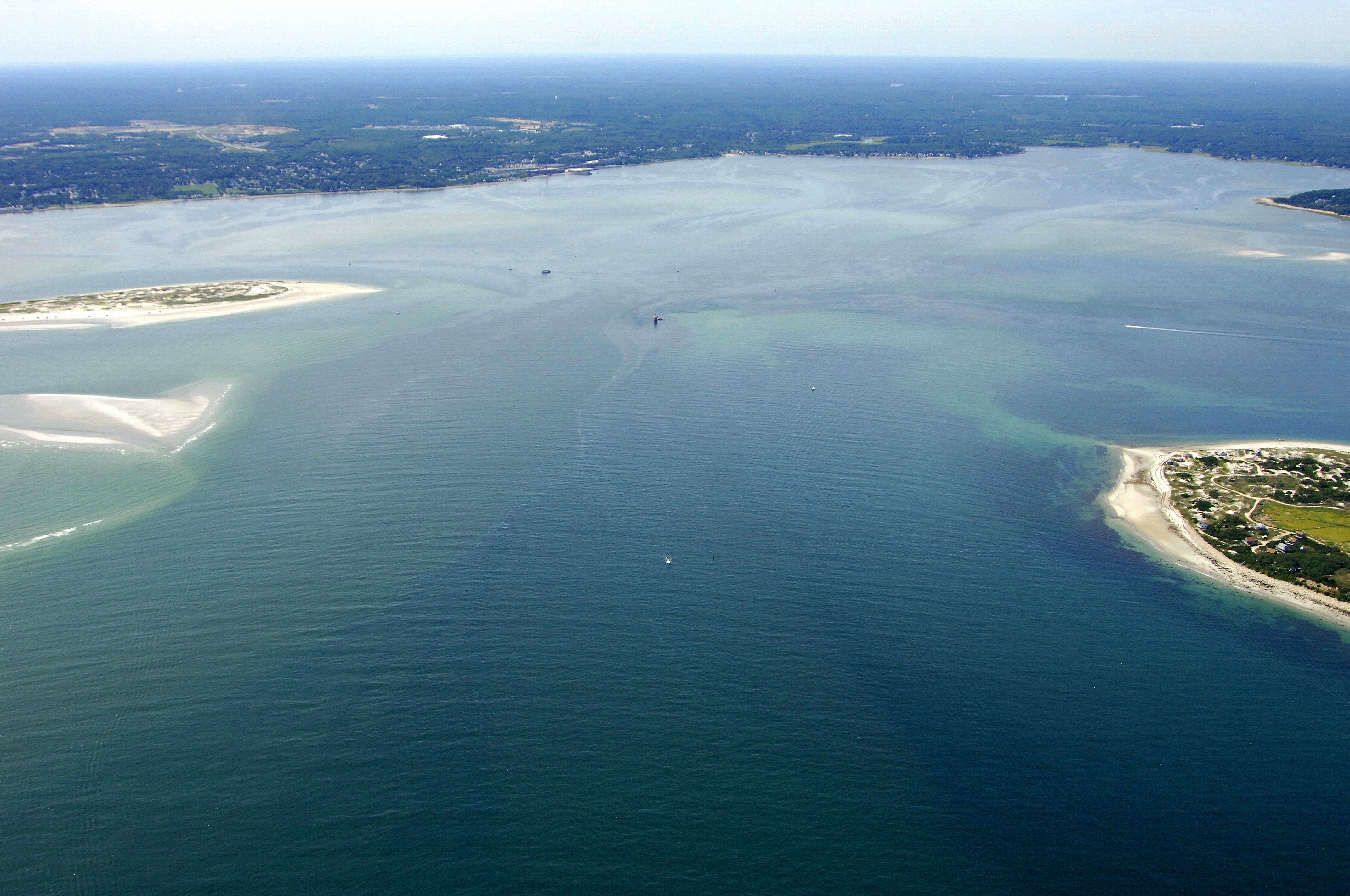
The image above is a view from the east looking west over the Plymouth Harbor entrance. Off to the right (north) of the image is Saquish Head, which is at the southern end of Saquish Neck. In the center of the image is Duxbury Pier Light, a small speck that you can zoom in on to see clearly. To the left are the sand shoals that extend north off of Plymouth Beach, and lastly, the town of Plymouth is located off the image to the left (south).
There are five marinas in the town of Plymouth and two of them accept transient guests; be sure to call ahead for availability before you arrive in the area. If you need fuel, three of the five marinas have both gas and diesel fuel. Brewer Plymouth Marine has a lift for haul-out and related repairs.
Navigating the Water:
Use NOAA Chart 13253.
Plymouth Harbor is reached via an approach from the east through Cape Cod Bay. The entrance to Plymouth Harbor starts with flashing green buoy 1, which is located near waypoint N41 59.713 W70 35.403. Once you have safely navigated to flashing green buoy 1, head west and leave the following buoys to port: Flashing green buoy 3, flashing green buoy 5, Green can 7, and then leave red nun buoy 6 to starboard.
Past red nun buoy 6, you will see the Duxbury Pier LIghthouse (35 feet above the water, flashing red twice every five seconds), which marks a steep shoal area on the north side of the inlet. Make sure you give it some room. Once you have arrived in the area of Duxbury Pier (obviously give it some room), head to the southwest and go between flashing green buoy 9 and red nun 8.
Next in line toward the south are red nun buoy 10 and green can buoy 11, which are located just north of the first Plymouth Harbor Channel Light (quick flashing red 12). Next in line, in order, are green can 13, red nun 14, green can 15, red nun 16, and then the second Plymouth Harbor Light (flashing green very four seconds 17). Finally, you have reached the last bend into the harbor itself. Simply follow in red nun 18, green can 19, red nun 20, green can 21, and then red nun 22 inito the harbor. There is a range light to help guide you in.
Local Notices to Mariners:
Local Notices to Mariners are available online from the U.S. Coast Guard.