


Spanish Wells Harbor
Spanish Wells, Eleuthera Bahamas
Marinas near Spanish Wells Harbor
| Name | Reviews | Max LOA | VHF | Dock Depth | Gas / Diesel | Lift / Crane | Wifi | Amps |
|---|---|---|---|---|---|---|---|---|
| Russell Island Docks | - | - | - | - | - | - | - | - |
| Spanish Wells Yacht Haven & Marina | - | - | - | - | - | - | - | |
| Spanish Wells Marine and Hardware | - | - | - | - | - | - | - | - |
| Spanish Wells Marine & Hardware | - | - | - | - | - | - | - | |
| R & B Boat Yard | - | - | - | - | - | - | - | - |
| Pinder's Supermarket | - | - | - | - | - | - | - | - |
| Ronald's Service Center | - | - | - | - | - | - | - | - |
| Gun Point Marina | - | 0.0 m | - | Low 0.0 mHigh 0.0 m | - | - | - | - |
| Spanish Wells Ferry | - | - | - | - | - | - | - | - |
| Fisherman's Dock (PLP Dock) | - | 0.0 m | - | Low 0.0 mHigh 0.0' | - | - | - | - |
| Valentines Resort & Marina | 10.0' | 16 | Low 29.5' | GYesDYes | - | 30, 50, 100 / 3 phase | ||
| Briland Club Marina | - | 300.0' | 11 | - | DYes | - | - | |
| Romora Bay Resort & Marina | - | 0.0' | - | Low 0.0 mHigh 0.0 m | - | - | - | - |
| Marine Services of Eleuthera | - | - | - | - | - | - | - | - |
| Habacoa | - | - | - | - | - | - | - | - |
Introduction:
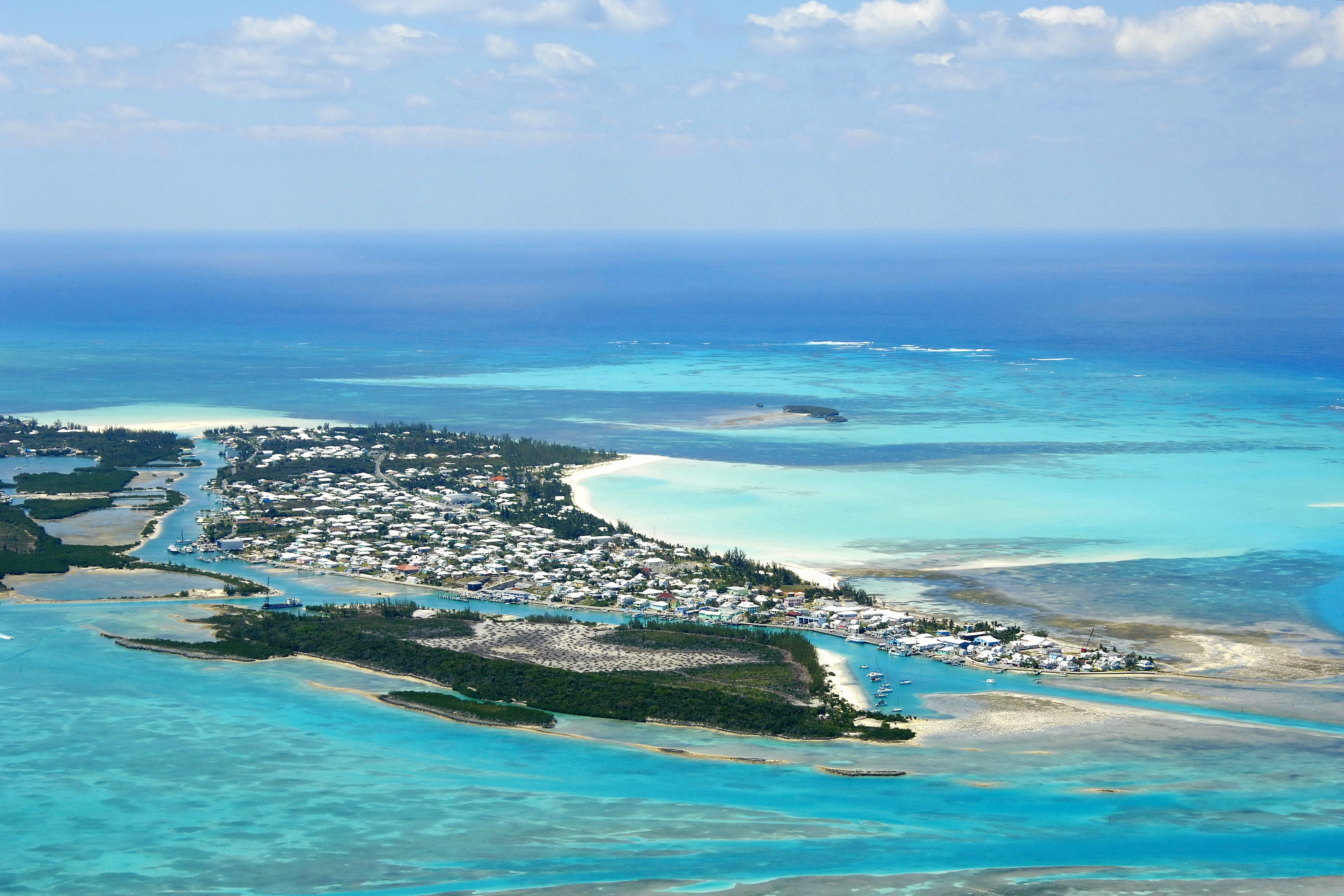
Spanish Wells, named for the Spanish ships that used to fill their water jugs here, is located just west of the north end of Eleuthera Island behind a protective barrier reef that keeps it calm during strong northers. Spanish Wells can be approached form the north or south.
Ashore are a variety of service including markets, stores, repair shops, drug stores, and photo processing, but alas, no liquor store is on the island. A number of small resorts dot the area and there are also several good sit down and take-out restaurants along the waterfront.
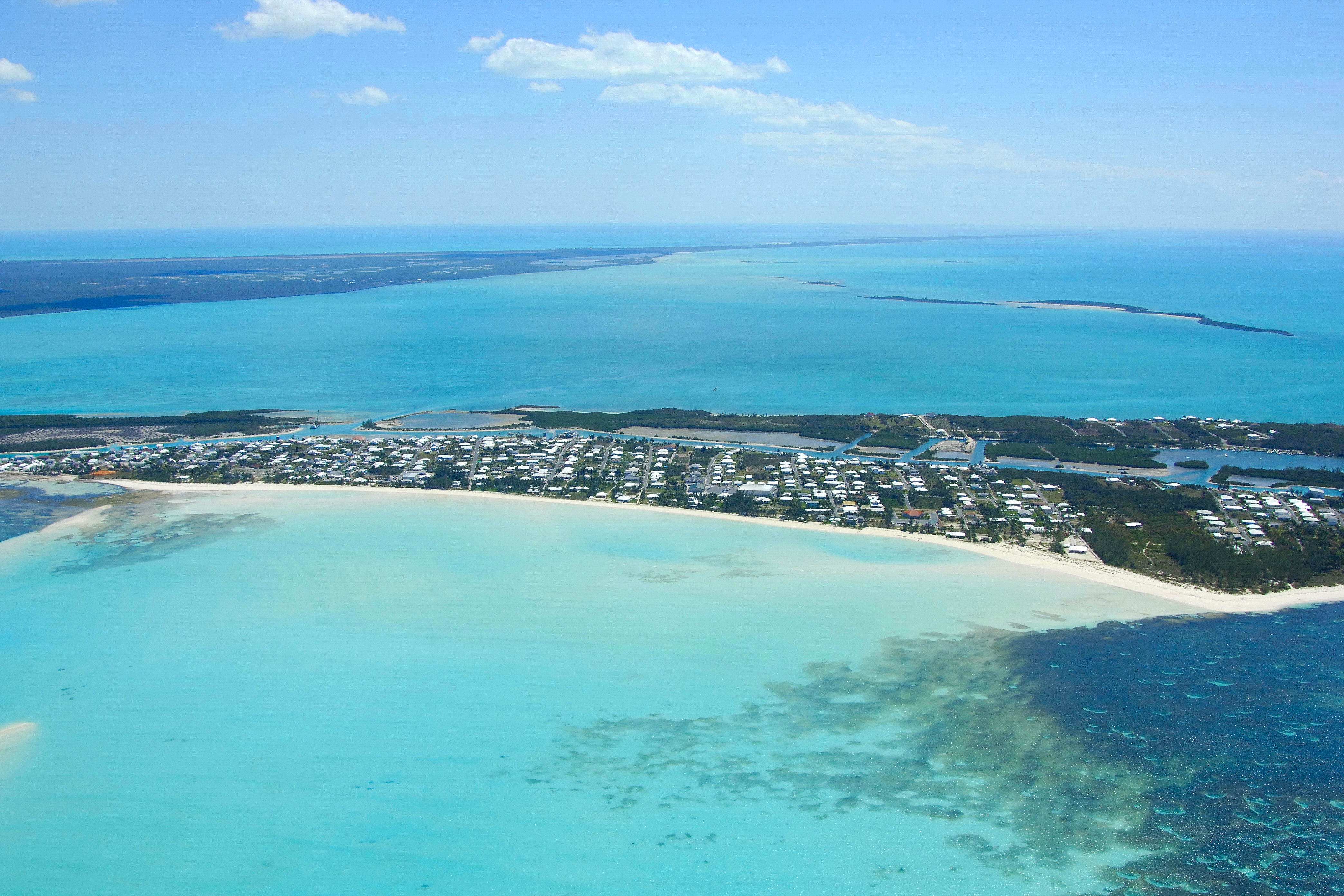
The view above is from the west, looking over Spanish Wells toward the east. Farther off to the east, Eleutera is visible, and even farther out near the top of the image, Harbour Island can be seen in the distance. Note the passage the winds around the left (north) side of the image, which is the primary entrance channel to the island. The sharp point of land on the left side of the image is Gun Point.
Navigating the Water:
Spanish Wells is normally reached from the Atlantic Ocean via a break in the reefs northwest of Salt Kettle Bay. Start your approach to the area from waypoint 25 35.500N 76 44.205W. Once you have picked up this point, set a course of 184 degrees true for a distance of approximately two miles, which will put you just north of the reef break. The next waypoint, 25 33.830N 76 44.306W, will place you farther in toward the inlet. From here, set a course of 171 degrees true for a distance of about .3 mile, and then turn toward the west on a course of 259 degrees true for .2 mile. There is another approach in this area from the east via Ben Bay, but the route requires a longer set of navigation through coral outcrops and shoals.
Clear of the point off the northwest end of Eleuthera, Set a course toward Gun Point (approximately 202 degrees true), making sure to mind the shoals the encroach on the channel from the west. After you have cleared Gun Point, set a course to the southeast to pick up the entrance channel to the back side of Spanish Wells. A ferry channel works across this area and runs from Eleuthera Island to the east westward across a dredged channel to Spanish Wells. The eastern portion of this channel is the entrance into Spanish Wells.
Alternatively, you can approach the area from the south around an approach from Meeks Patch at waypoint 25 31.473N 76 46.994W. Once you have picked up the waypoint, head about two miles on a course of 65 degrees true to pick up the south entrance into Spanish Wells. Two buoys mark the edges of the channel between Russell and Charles islands, where you will find a passage withe eight-foot depths.
If you are unsure of any route in the are, it is suggested that you hire a pilot to help you weave your way in. A simple call on VHF Channel 16 (available pilot will do) will allow you to arrange for guidance through the channels.
Spanish Wells has one primary marina, which is located about one mile in from the beginning of the eastern entrance channel on the north side of the harbor. Moorings are available just to the northeast of Charles Island. Hail Cinnabar on VHF Channel 16 for details. Anchorage is available outside of Spanish Wells south of Gun Point, but Spanish Wells harbor is too narrow to drop the hook safely.
Local Notices to Mariners:
See our Local Notices to Mariners blog for updates on the latest conditions and advisories for this area.
Transportation:
The North Eleuthera Airport is located about six miles southeast of Spanish Wells. US Airways and Continental provide service to and from Fort Lauderdale and Miami on regular schedules. Bahamas Air serves the airport with regular service to and from Nassau.