


Fishers Island Harbor
Fishers Island, New York United States
Marinas near Fishers Island Harbor
| Name | Reviews | Max LOA | VHF | Dock Depth | Gas / Diesel | Lift / Crane | Wifi | Amps |
|---|---|---|---|---|---|---|---|---|
| Fishers Island Yacht Club | - | 10 | - | - | - | 30, 50 | ||
| Pirates Cove Marina | 50.0' | - | Low 0.0 mHigh 0.0' | GYesDYes | - | - | 30 | |
| Groton Long Point Association | - | - | - | - | - | - | - | - |
| Groton Long Point Yacht Club | 0.0 m | - | Low 0.0 mHigh 0.0' | - | - | - | - | |
| Palmer's Cove Marina | - | 23.0' | - | Low 2.0'High 5.0' | - | - | - | - |
| Noank Shipyard | 300.0' | 9 | Low 12.0' | G$5.40/galD$5.60/gal | LYesCYes | 30, 50 | ||
| Spicer's Noank Marina | 60.0' | 68 | - | - | LYesCYes | - | ||
| Maxwell Boat Yard | - | 0.0' | - | Low 0.0 mHigh 0.0' | - | - | - | - |
| Shennecossett Yacht Club | - | - | - | GYesDYes | - | - | - | |
| Haring's Marine | - | 0.0' | 9 | Low 0.0 mHigh 0.0' | GYesDYes | - | - | - |
| Pine Island Marina | - | 68 | - | - | LYes | - | ||
| Ram Island Yacht Club | - | - | - | - | - | - | - | - |
| Noank Marine Service | - | 0.0 m | - | Low 0.0 mHigh 0.0' | - | - | - | - |
| Noank Village Boatyard | 130.0' | 72 | - | - | LYesCYes | - | ||
| Mason's Island Yacht Club | - | 0.0 m | - | Low 0.0 mHigh 0.0' | - | - | - | - |
Introduction:
Fishers Island is located just a short distance off the Rhode Island and Connecticut coastline, but it belongs to New York state. Ashore on the island you will find a bucolic fishing village atmosphere with plenty of beaches, nature trails, excellent fishing and not one traffic light. People visit Fishers Island to get away from it all, and even on the busiest of summer weekends, the place has a definite calm about it.
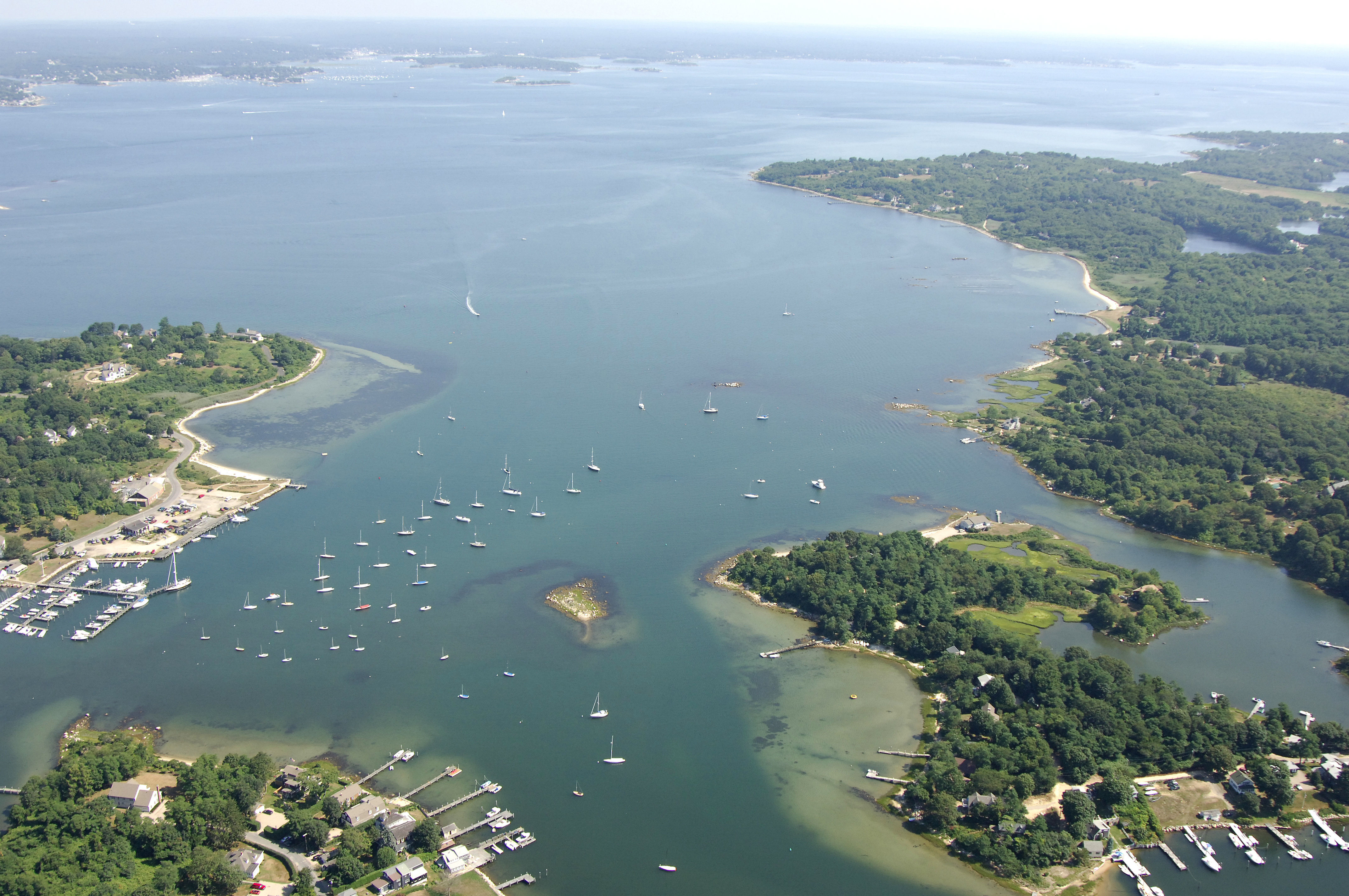
West Harbor, Chocomount Cove, and East Harbor are located on the north side of the island and posses all the marina and anchorage accommodations. West Harbor is the best protected and most popular of the harbors, and this is where you will find the ferry landing, marinas and a broad mooring field. There are three marinas in West Harbor, and at least one of them will accept transient guests, but call ahead for reservations.
Navigating the Water:
Use NOAA Chart 12372.
The main hazard to navigation when traveling the Fisher Island/Sound area is the numerous rock outcroppings an ledges that dot the area. Luckily, most of them are well-marked with powerful lights and well-placed buoys.
West Harbor is approached form the north via Fishers Island Sound. From the north, pick up flashing red bell buoy 2 above North Hill, and green can 3, which marks South Dumpling a little to the east. Once you have safely cleared these two obstacles, chart a course for red nun 4 a little farther to the southeast, and then flashing red buoy 6 at Hawks Nest Point near the entrance to the harbor.
The 12-foot-deep channel into the harbor continues with red nun 8 and red nun 10, which both lead down the west side of the extensive mooring field. A green nun buoy (7) marks Lewis Rock to the east (Lewis Rock is visible in the center of the image above).
Moorings are visibly scattered throughout the harbor, and there is a small anchorage for boats drawing less than three feet in the extreme southern end of West Harbor. Marinas are located to starboard at the ferry landing when you enter.
Local Notices to Mariners:
Local Notices to Mariners are available online from the U.S. Coast Guard.
Transportation:
Since it has no bridges or roads, Fishers Island is only reachable by boat, ferry or civil aircraft. Ferry boats run to and from the island on regular schedules, and you can view departure and arrival schedules by looking in the Helpful Links section below.