


The Gut Harbor
South Bristol, Maine United States
Marinas near The Gut Harbor
| Name | Reviews | Max LOA | VHF | Dock Depth | Gas / Diesel | Lift / Crane | Wifi | Amps |
|---|---|---|---|---|---|---|---|---|
| Gamage Shipyard | - | - | - | - | - | LYes | - | |
| Osiers Wharf | - | 0.0 m | - | Low 0.0 mHigh 0.0 m | - | - | - | - |
| Bittersweet Landing Boat Yard | - | 0.0 m | - | Low 0.0'High 0.0' | - | - | - | - |
| South Bristol Fisherman's Co-Op | - | - | - | - | - | - | - | - |
| Coveside Restaurant & Marina | 60.0' | 9 | Low 9.0' | - | - | - | ||
| Washburn & Doughty Shipyard | - | - | - | - | - | - | - | - |
| Hodgdon Yachts | - | 0.0 m | - | Low 0.0 mHigh 0.0' | GYesDYes | - | - | - |
| Ocean Point Marina | 0.0' | 18 | Low 0.0 mHigh 0.0' | GYesDYes | LYes | 30, 50 | ||
| Water's Edge Motel and Cottages | - | - | - | - | - | - | - | - |
| Pemaquid Beach Boat Works | - | - | - | - | - | - | - | - |
| Little River Boat Club | - | 0.0 m | - | Low 6.0'High 0.0 m | - | - | - | |
| Luke's Boatyard | - | - | - | - | - | - | - | |
| Pemaquid Marine | - | - | - | - | - | - | - | - |
| Smugglers Cove Inn | 30.0' | - | - | - | - | - | ||
| Linekin Bay Resort | - | 68 | - | - | - | - |
Introduction:
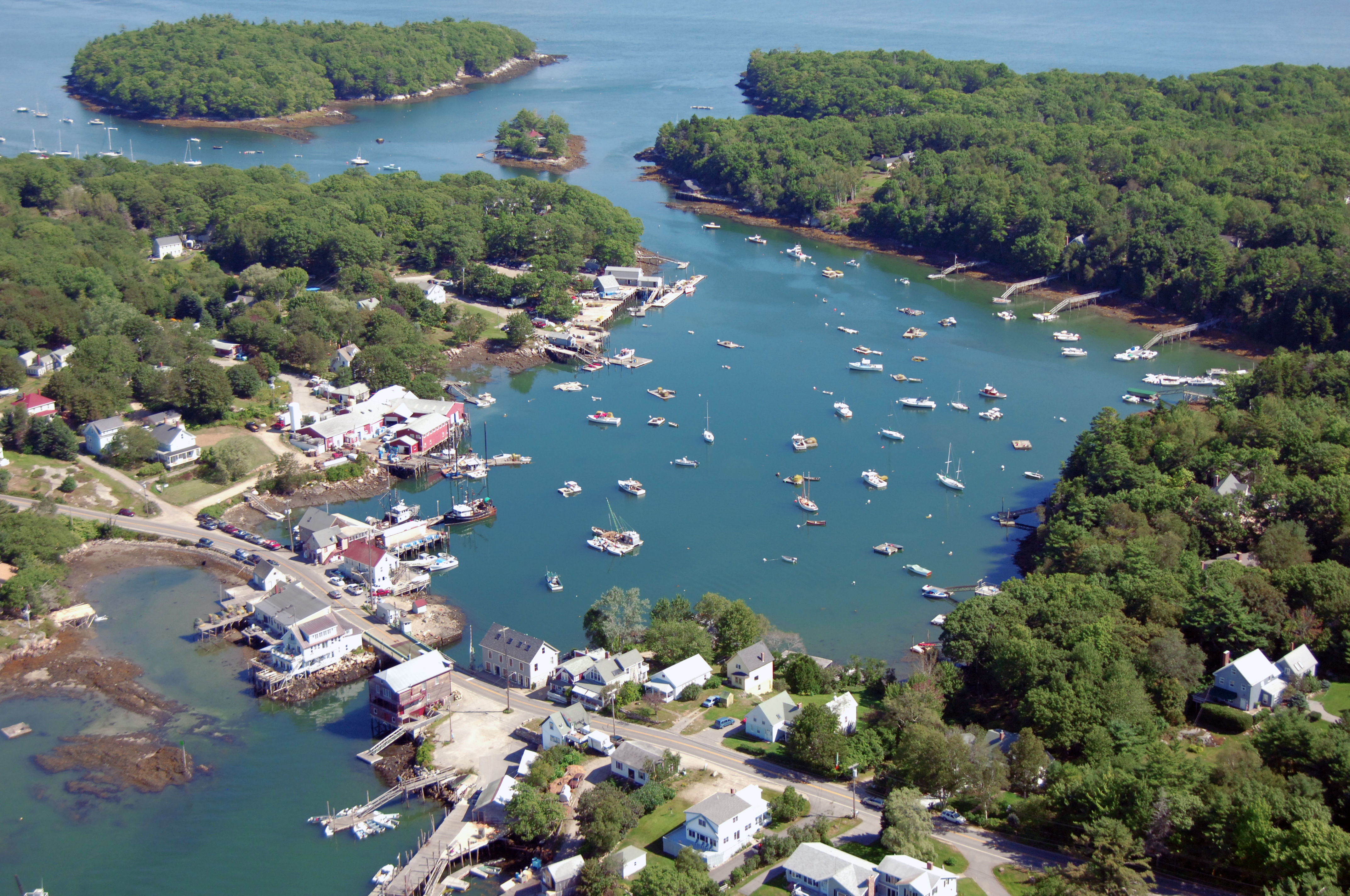
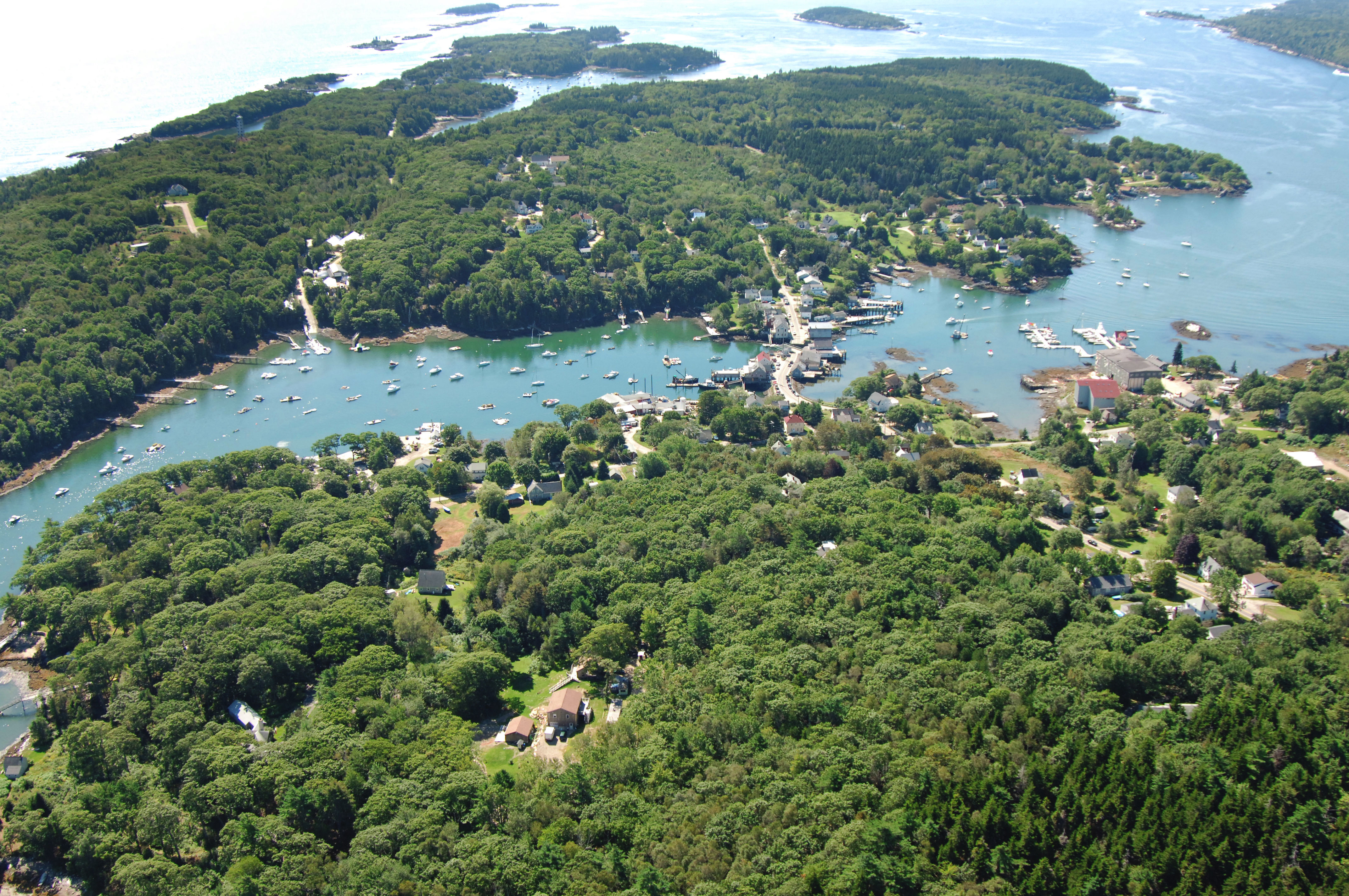
The Gut is a narrow passage of water that not only allows passage between Johns Bay and the Damariscotta River, but it also divides and creates Rutherford Island away from the mainland. The Gut is located off the town of South Bristol and situated three miles northwest of Pemaquid Point and four miles northeast of Boothbay Harbor.
The image above is a view from the northeast looking southwest over the town of South Bristol and The Gut where it empties into the Damariscotta River. The portion of land on the left-hand side of The Gut is Rutherford Island, while to the right is the mainland. A close look at the crossing over The Gut shows a small swing bridge.
Despite its relatively small geographical size and narrow channel, The Gut is home to four well-equipped marine service and marina facilities. Two of the facilities are located on the west side of the aforementioned swing bridge and two are located to its east.
If you are looking transient slips, Gamage Shipyard Storage and Repair and Osiers Wharf both have slips available for visiting boaters. Both of these facilities also pump gas and diesel fuel. The moorings in the Gut are maintained by the Bittersweet Landing Boatyard and Gamage Shipyard Storage and Repair. Bittersweet Landing Boatyard and Gamage Shipyard Storage and Repair both have lifts for haul-outs and related repair services.
History:
One of the oldest towns in Maine, Bristol is named after the city of Bristol, England. Bristol was incorporated in 1765, while Maine was still part of Massachusetts.
Shell heaps left by early inhabitants date back to the 4th millennium B.C. and Norse explorers may have reached Maine in about 1000 A.D. By the time the French and English explorers reached Maine during the seventeenth century the land was occupied by Abnaki Indians. Early European settlement of the coastal region was hindered by repeated conflicts between the French, English, and Native Americans.
In the 18th century, Maines prosperous fishing, lumbering, and shipbuilding industries flourished. In 1915, South Bristol incorporated and separated from Bristol.
Navigating the Water:
Use NOAA Chart 13293.
[b]East Approach[/b]
The east side of The Gut is approached via an easterly approach from Johns Bay south of Corvette Ledge. First set a course to intercept green can 1, which marks the location of Corvette Ledge, a three-foot-deep, dangerous rock ledge. Green can buoy 1 is located at an approximate waypoint of N43 52.310 W69 32.766. Make sure you give green can buoy 1 considerable room; Corvette Ledge is quite dangerous.
Once you have cleared green can buoy 1, head north, and then around the north wide of Witch Island to the west, making sure to stay well north of the northern tip of the island, where a rock shoal lies. After you are well west of Witch Island, head south and follow the unmarked, but fairly easy to see channel toward the swing bridge (three-foot vertical clearance).
[b]West Approach[/b]
Use NOAA Chart 13293.
The western side of The Gut is approached through the Damariscotta River just east of Farnham Point. Minimum depths in the Gut are between five and eight feet, with the shallowest depths occurring at the swing bridge in South Bristol. The only other major challenge to navigation is a strong current that runs here on both tides and hundreds, if not thousands of lobster pot floats on the approach.
From the Damariscotta River, first pick up red nun buoy 6, which is located at an approximate waypoint of N43 51.420 W69 34.039. Once you have successfully picked up red nun buoy 6,set a course to the northeast to intercept red daybeacon 2, and then farther on to green daybeacon 3. The swing bridge normally opens on signal, but if you need to pass through, make sure to radio ahead and verify, especially if there is a strong current running.
Local Notices to Mariners:
Local Notices to Mariners are available online from the U.S. Coast Guard.
Transportation:
The closest airport is the Wiscasset Airport, some 11 miles as the crow flies from South Bristol. Knox County Airport is 30 miles to the west.
Most ground-based transportation is by foot or bicycle. There is no taxi or bus service in South Bristol.