


York Harbor
York Harbor, Maine United States
Marinas near York Harbor
| Name | Reviews | Max LOA | VHF | Dock Depth | Gas / Diesel | Lift / Crane | Wifi | Amps |
|---|---|---|---|---|---|---|---|---|
| Donnell's Marina | - | 0.0 m | - | Low 0.0'High 0.0 m | - | - | - | - |
| Agamenticus Yacht Club | - | 0.0' | - | Low 0.0'High 0.0' | - | - | - | - |
| York Harbor Marine Service | - | - | - | - | - | - | - | - |
| York Town Docks & Moorings | - | 0.0' | - | Low 0.0 mHigh 0.0' | - | - | - | - |
| Pepperell Cove | 65.0' | 71 | - | - | - | - | ||
| Safe Harbor Kittery Point | 65.0' | 71 | - | - | LYesCYes | 30, 50 | ||
| Kittery Harbormaster | - | - | - | - | - | - | - | - |
| Portsmouth Yacht Club | 60.0' | 78 | Low 10.0' | G$4.20/galD$4.00/gal | - | - | ||
| Back Channel Marina | - | - | - | - | - | - | - | - |
| Navy Yacht Club | - | 0.0 m | - | Low 0.0'High 0.0' | GYesDYes | - | - | - |
| Port Harbor Marine Kittery | - | - | - | - | - | - | - | - |
| Kittery Point Yacht Club | 0.0 m | - | Low 0.0 mHigh 0.0' | - | - | - | - | |
| Piscataqua Marina | 125.0' | 9 | Low 22.0' | - | - | 30/50 | ||
| NH Port Authority Commercial Fish Pier | - | - | - | - | - | - | - | - |
| Safe Harbor Wentworth By The Sea | 200.0' | 71 | Low 10.0' | G$4.25/galD$4.10/gal | - | 30, 50, 100, 100 3-phase |
Introduction:
York Harbor is the first major harbor in Maine past the New Hampshire/Maine state line heading north.
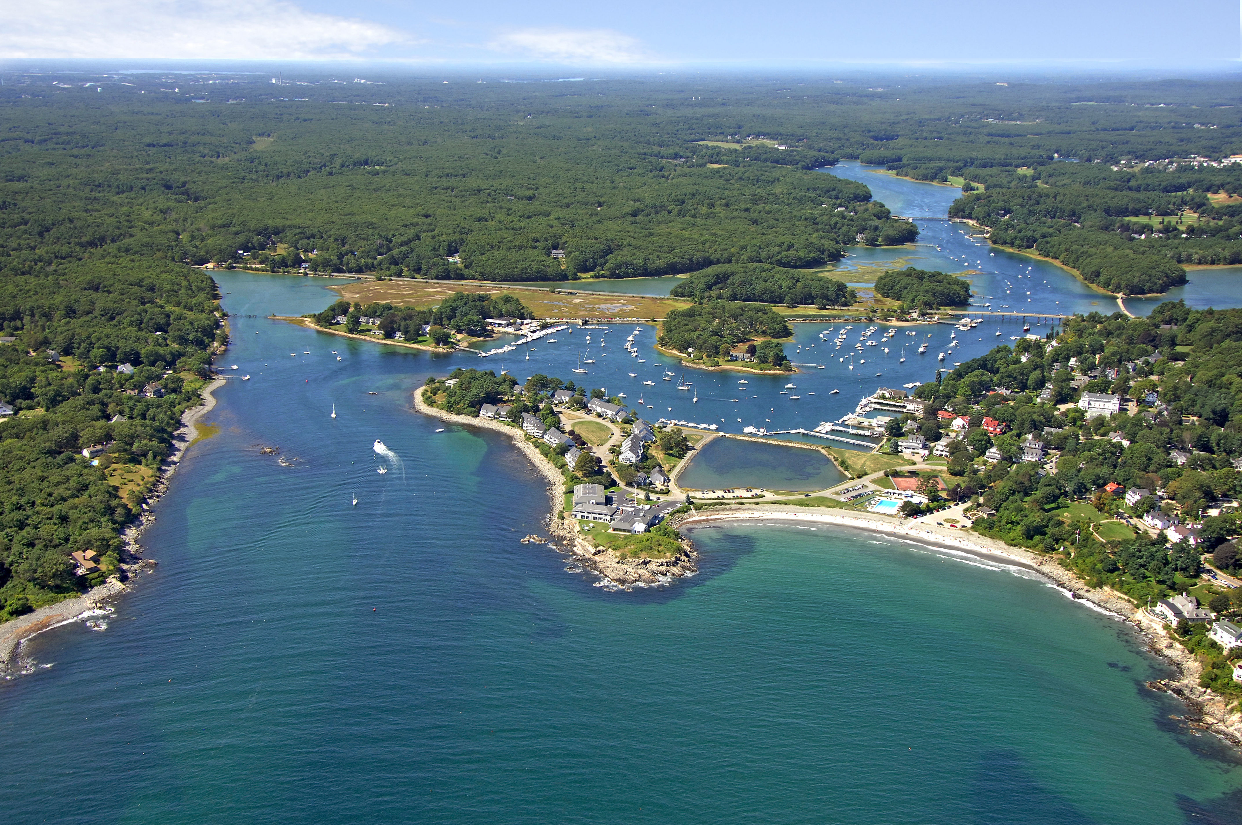
The image above is a view from the southeast looking northwest over the York River where it empties into York Harbor and the Atlantic Ocean. The rounded gravel spit off to the right (north) side of the image is Stage Neck, while off to the left (south), the tip of Harris Island is visible. A sharp eye can pick out red nun buoy 8 in the lower right-hand portion of the image, while green daybeacon 9 is visible just to the right of Harris Island.
There are three marine service and marina facilities in York Harbor and at least one of them accepts transient guests and another administers some moorings in the harbor area.
History:
York is actually the fourth name that the town has known. The earliest records refer to the general area as Agamenticus, after the original inhabitants. The first English settlers, having come from the region of Bristol, England, lent that name to the town until it became a chartered city under Sir Ferdinando Gorges, who renamed it Gorgeana in 1642. The name York was appointed after the fall of the Loyalists under Cromwell in 1652, commemorating the town (York, England) in which Cromwell defeated the King's forces.
The center of York Village was along Lindsay Road as York River was the most important mode of transportation. After the Abenaki Candlemas Day Raid of 1692, the town reorganized itself on higher ground that evolved into the present day center of religious, civic and governmental functions.
As tourism developed in the late nineteenth century, more and more of the town's tax dollars came from the businesses and homes of the wealthy summer residents. Although they sought the colonial quaintness of the town, they also wanted the amenities of the cities: public water, streetlights, sidewalks, paved roads, electricity and libraries. The locals, however, had the advantage of the vote, and farmers would not vote for improvements at York Harbor or York Beach.
[i]Information Courtesy Town of York[/i]
Navigating the Water:
Use NOAA Chart 13283.
York Harbor is reached via an approach from the east via the Atlantic Ocean. Coming in from the Atlantic, first set a course for red and white Morse (A) buoy YH, which is located at an approximate waypoint of N43 07.761 W70 37.026. Red nun buoy 2 is located just northwest of red and white Morse (A) buoy Once you have safely navigated to red and white Morse (A) buoy YH, set a new course of about 287 degrees magnetic for approximately .8 miles to arrive between green can 3 and red nun buoy 4.
About a quarter-mile west of green can 3 and red nun buoy 4 is red nun buoy 6, which is followed closely by green can 7, red nun buoy 8, and then green daybeacon 9 at the turn past Stage Neck. Depths on the approach and in the harbor area range from eight to 11 feet.
A fixed bridge with a 15-foot vertical clearance limits travel upstream for all but the lowest clearance boats. Marine facilities line the north and south shores of the river.
Local Notices to Mariners:
Local Notices to Mariners are available online from the U.S. Coast Guard.
Things To Do/Local Events:
Camping, hiking, boating, fishing, shopping and outside exploration of the surrounding areas are all popular activities in York. The Nubble Lighthouse at Cape Neddick, 3.5 miles to the northeast of town makes for a great bike ride or invigorating hike. The lighthouse has been in service since 1879 and is one of the stateliest on the Maine Coast.
See the Helpful Links section at the bottom of this page for detailed information.
Transportation:
The Pease International Tradeport Airport is located in Porsmouth, NH about eight miles to the southwest of York. Shuttle and taxi service is available through the airport by telephone.
A couple of small taxi companies operate in the local York area.