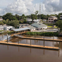
Frederica River Inlet
About
Introduction:
The Frederica River is a small side channel that breaks off the Intracoastal Waterway east of Lanier Island along St. Simons Island, which is a major coastal resort area on Georgias East Coast. The Frederica River empties into St. Simons on its southern end where it rejoins the ICW route near Mile marker 674.
The image above is a view from the south looking north over the Frederica River where it empties into St. Simons Sound. St. Simons Island lies to the right (east), while Lanier Island is located to the left (west). The Golden Isles Marina (transient slips available) can be seen just south of the nine-foot fixed vertical clearance bridge on the west side of the Frederica River channel.
Navigating the Water:
Use NOAA Charts 11489 and 11507.
Te Frederica River is not part of the Intracoastal Waterway route, rather it is a small side channel that offers access to a well-equipped marina and opportunities to explore St. Simons Island, a major Georgia resort Island.
Though the approach from the north off the Intracoastal Waterway at flashing green 241 is deep enough for most vessels, if you take this route, you must be able to clear a nine-foot fixed vertical clearance bridge midway along the passage.
The typical approach to the Golden Isles Marina is from the south off the Intracoastal Waterway from flashing green 247. Once you have reached flashing green 247, head southeast to intercept green daybeacon 1 at the end of a long shoal that extends southeast off Lanier Island.
From green daybeacon 1,head north and follow red daybeacon 2, green daybeacon 3, green daybeacon 5, and red daybeacon 7 up into the Frederica River toward the marina. Depths in the rive range from eight to ten feet.
Local Notices to Mariners:
Local Notices to Mariners are available online from the U.S. Coast Guard.


