Mystic River Inlet
| Mystic, Connecticut United States | |
| 41° 20' 56.04'', -71° 58' 10.93'' | |
| Mystic Harbor |


You might also consider...


About
Introduction:
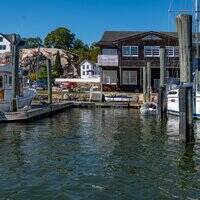
The Mystic River is located off Mystic Harbor and is one of the most popular boating centers in Connecticut. With a wide array of marine services, thousands of moorings and a setting that is relatively well-protected, the town of Mystic and the Mystic River fill up quickly in season. This is the home of the Mystic Seaport museum, a popular local attraction.
Inside the Mystic River are no less than seven marinas, and many of them have facilities available for transient guests. Like any popular boating center, you will be well served to call ahead and arrange your spot for the evening in advance, or arrive early to the first-come first served moorings outside the rivers entrance. There are spots for anchoring about, but most of them are not conveniently located close to town.
Navigating the Water:
Use NOAA Chart 12372.
To reach Mystic River, you will have to work your way up Mystic Harbor from Fishers Island Sound. Mystic Harbor is approached form the south between Ram Island Shoal and Morgan Point in the town of Noank. The start of the approach into Mystic Harbor from Fishers Island Sound is marked by green can 1 about a mile southwest of Swimming Rock. From here, head north toward red nun 2 and green can 3 marking Planet and Swimming rocks, respectively.
The rest of the channel up to the town of Mystic hugs the west shore of Mystic Harbor for about a mile, and then it bends back to the east at Mason Island. Picking up from red nun 2 and green can 3, plot a course for quick flashing red buoy 4, and note on the chart that this is a rocky area that requires your attention. Next head toward quick flashing green 5 at the start of the narrow entrance channel to Mystic, and then follow red nuns 6 through 20 until you reach green can 19 at the eastward bend south of Sixpenny Island.
Green can 21, red nun 22, green can 23 and red nun 24 complete the turn between Sixpenny and Mason islands. The cruise into Mystic from here is simple and easy; just follow the well placed string of buoys up to the town of Mystic at the Mystic Swing Bridge (eight-foot closed vertical clearance, opens at :40 past the hour from 7:15 a.m. To 7:15 p.m. And on demand at all other times).
Once you have cleared the swing bridge, you will find marinas lining both sides of the channel up to the next opening bridge (bascule, four-foot closed vertical clearance), which opens on signal. The Mystic Seaport is located near the head of the river past the second opening bridge, and there are more than 50 transient slips available here (call ahead for reservations). In town provisioning is easy, with a grocery store, pharmacy and liquor store all close by.
In addition to an extensive field of hefty moorings, Mystic has over 14 marinas in the harbor and up beyond the Mystic Swing Bridge. All but five of these marinas cater to transient guests, and several of them have haul-out facilities and fuels. Mystic is an excellent town for historic and seafaring exploration and is the location of the Mystic Seaport Museum, the towns biggest draw.
Local Notices to Mariners:
Local Notices to Mariners are available online from the U.S. Coast Guard.