Back Creek Inlet - Solomons
| Solomons, Maryland United States | |
| 38° 19' 13.08'', -76° 27' 3.97'' | |
| Solomons Island |


You might also consider...


About
Introduction:
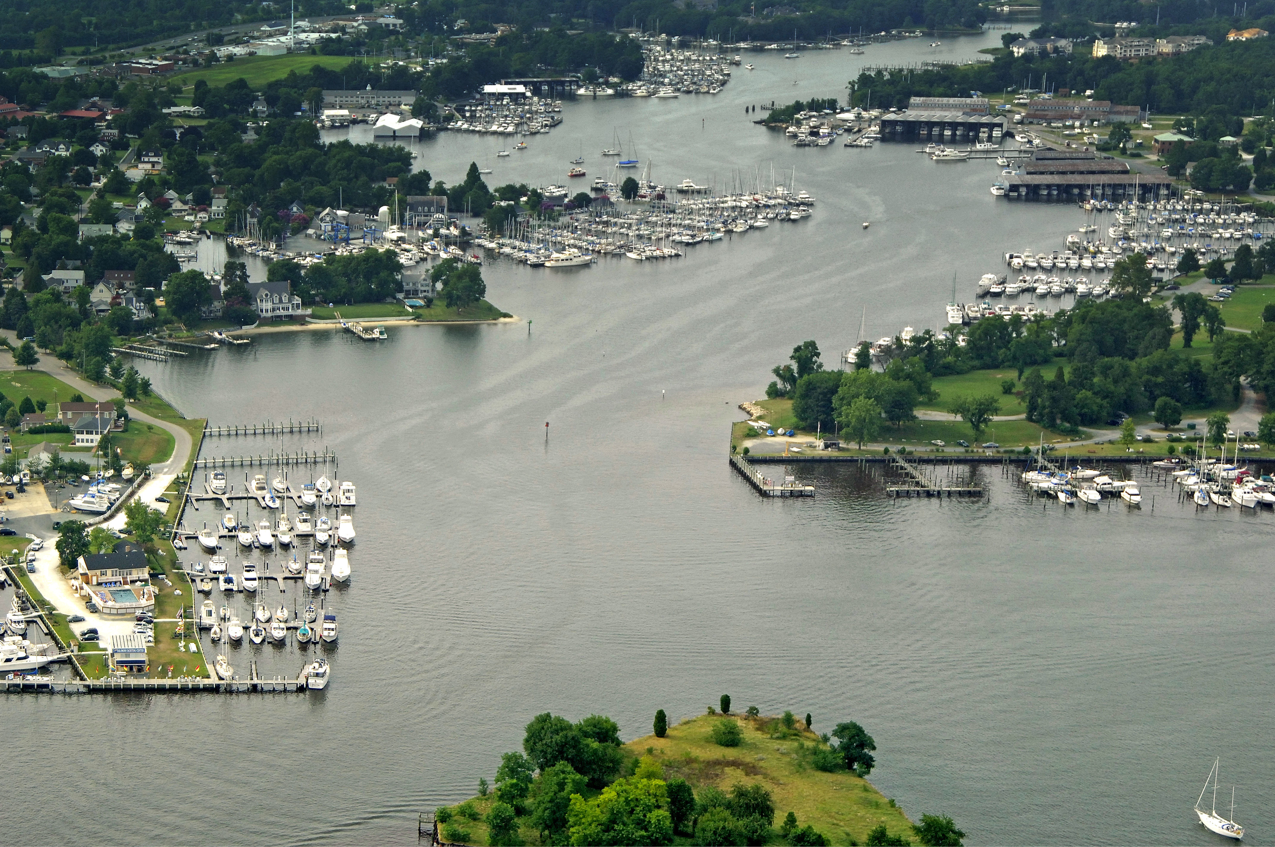
Back Creek is the center of yachting activities in the Solomons area. With over eight marinas crammed within one mile along its shore, there is little that cannot be provided for boaters. If youre up for a little shore time, the Calvert Marine Museum is located on the west shore of the creek, and there is a Holiday Inn farther up that has a grocery store close by.
The image above is a view from the south-southeast looking west-northwest over Back Creek. In the bottom of the image is Ma Leg Island with Janes Point showing up just to the islands left (west). Solomons Yachting Center is located on Janes Point, and its facilities can be clearly seen.
Farther up to the left (west) is the expansive Zahnisers Yachting Center, which has all services and an excellent repair staff. Next up on the left is Spring Cove Marina, which has plenty of transient slips, gas and diesel fuel, a lift, and marine supplies at its ships store. The last marina up on the left is Hospitality Harbor Marina, which caters exclusively to transient guests. There is also an excellent anchorage just off the marina, though it is a bit unprotected from strong fall northwesters.
On the right (east) is Calvert Marina, an extensive transient and repair facility, while just north is Washburns Boatyard, which while not accepting transients, does have excellent repair facilities.
Navigating the Water:
Use NOAA Chart 12264.
Access to Solomons Islands two creeks is via a shared entrance south of Ship Point just west of Ma Leg Island. Ma Leg Island is not charted with a name, but it is easily recognizable both on the chart and in person. The triangular island has sturdy breakwaters and two flashing red lights (2 and an unnumbered aid). Behind the island to the west is a popular anchorage just off Solomons restaurants and attractions. Do keep in mind that these attractions can be quite noisy at night, however.
[b]Southern Approach[/b]
If you are approaching from the south, flashing red 6 (N38 18.934 W76 26.440) marks the western end of a shoal area and is followed by red daybeacon 2 a little farther north. There is also shoal that extends south from Solomons Island that is marked with flashing red 6A (N38 18.741 W76 27.292). You can safely run between flashing red 6A and aforementioned flashing red 6.
Next, continue north toward red daybeacon 2 and flashing green 3. At flashing green 3 head toward red daybeacon 4, where you can head in toward Back Creek past Ma Leg Island.
[b]Eastern Approach[/b]
If you are coming up the Patuxent River from the east, it is easiest to travel north of the aforementioned shoal into Back Creek and Solomons, but do not cut any of the markers on this channel too close; there is shallow water right near them, so give them room.
Green daybeacon marks the start of the approach near waypoint N38 19.265 W76 23.102. Red daybeacon 2 is just north of green daybeacon 1. From here, set an approximate course of 280 degrees magnetic for about .6 mile to intercept green daybeacon 3 and red daybeacon 2A. Soon after, you will find red daybeacon 4 at the shred mouth of Back and Mill Creeks where you can head your way in past Ma Leg Island.
Local Notices to Mariners:
Local Notices to Mariners are available online from the U.S. Coast Guard.