Bar Harbor Inlet
| Bar Harbor, Maine United States | |
| 44° 23' 22.2'', -68° 11' 31.2'' | |
| Bar Harbor |


About
Introduction:
Bar Harbor is located on the northwest corner of Mount Desert Island just west of Winter Harbor. Geographically speaking, Bar Harbor is six miles west of Winter Harbor and 37 miles northeast of Vinalhaven.
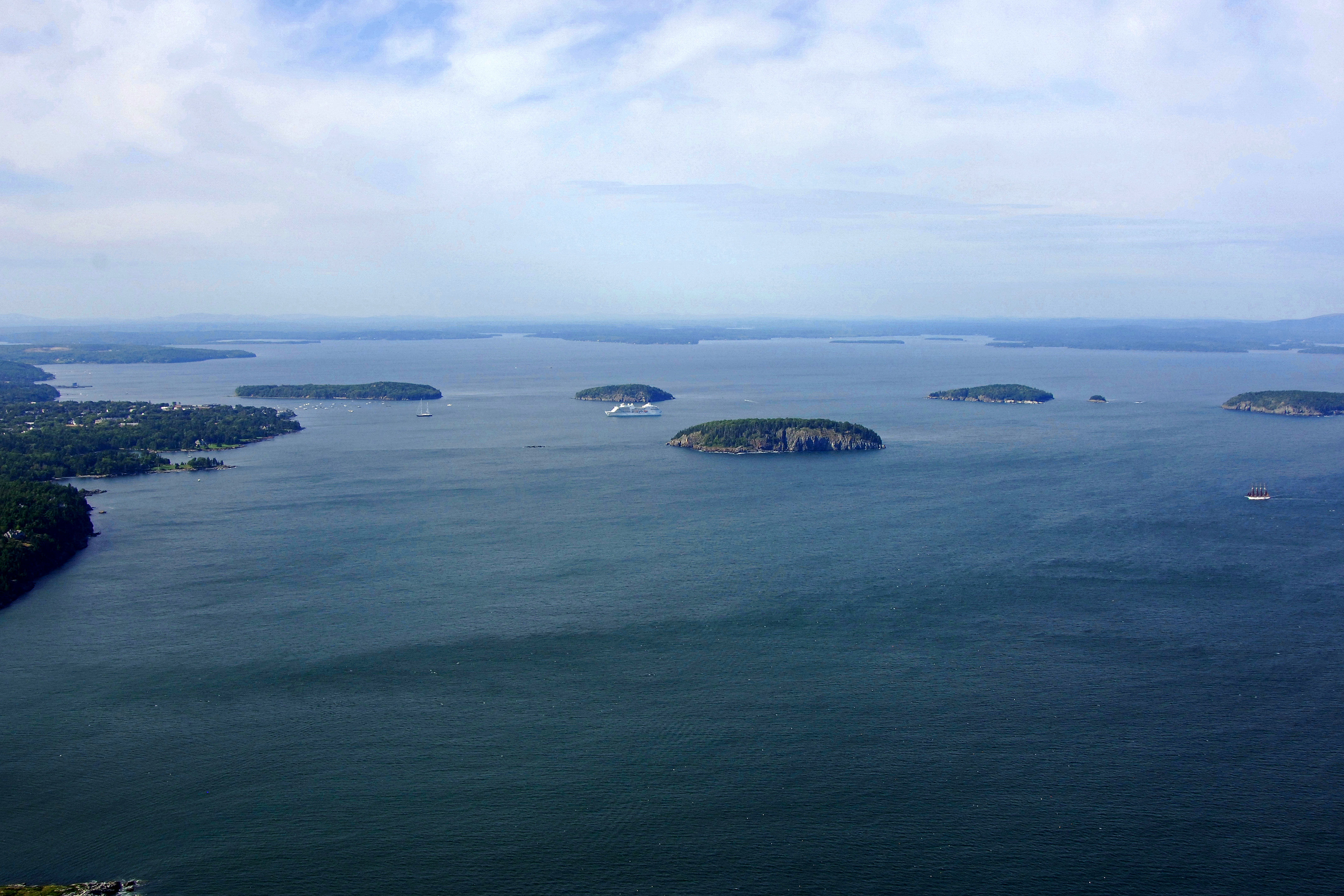
The image above is a view from the west looking east over Bar Harbor just west of Bar Island. Off to the right (south) is the town of Bar Harbor, while Bar Island is off to the left (north). Next up on the right a little farther up is Bald Porcupine Island, while the long sliver of land on the water near the horizon is Ironbound Island just west of Winter Harbor.
The strip of islands off to the left are aptly known as The Porcupines. The first separate island on the left is Sheep Porcupine Island, which, following the line to the horizon on the left, is followed by Burnt Porcupine Island, and then Long Porcupine Island. A cruise ship (frequent summer visitors to the area) can be seen between Bald Porcupine and Sheep porcupine islands.
There are two major marine facilities in Bar Harbor: Harbor Place and Bar Harbor Municipal Pier. Both facilities accept transient guests at theirs slips, and both administer sets of transient moorings in the harbor. If you need gas or diesel fuel, Harbor Place pumps both.
Navigating the Water:
Use NOAA Chart 13318.
Bar Harbor is typically reached via a passage from the south or north through Frenchman Bay.
If you are coming in from the north, first set a course for green can 9, which marks the location of Bald Rock and is located at an approximate waypoint of N44 25.369 W68 12.594. Once you have safely navigated to green can 9, set an approximate course of 165 degrees magnetic for about 1.8 miles until you reach green can 7 on the east side of Sheep Porcupine Island. Past green can 7, head a little farther south, and then head west into the harbor toward the moorings and the town waterfront.
From the south, first set a course toward waypoint N44 23.565 W68 10.159. Once you have arrived in the area of the waypoint, set a course to the east into Bar Harbor.
Local Notices to Mariners:
Local Notices to Mariners are available online from the U.S. Coast Guard.