

Westport Harbor
Westport, Massachusetts United States
Marinas near Westport Harbor
| Name | Reviews | Max LOA | VHF | Dock Depth | Gas / Diesel | Lift / Crane | Wifi | Amps |
|---|---|---|---|---|---|---|---|---|
| F.L. Tripp & Sons, Inc. | - | 9 | - | G$5.17/galD$5.69/gal | - | - | - | |
| Westport Yacht Club | 0.0' | 9 | Low 0.0 mHigh 0.0' | - | - | - | - | |
| Spindle Rock Yacht Club | - | 0.0 m | - | Low 0.0 mHigh 0.0 m | - | - | - | - |
| Westport Town Dock | - | - | - | - | - | - | - | - |
| Leach & Son | - | 0.0 m | - | Low 0.0 mHigh 0.0 m | - | - | - | - |
| Shamrock Marine | - | - | - | - | - | - | - | - |
| Club 380 | - | 0.0 m | - | Low 0.0 mHigh 0.0 m | - | - | - | - |
| The Back Eddy Restaurant | - | - | - | - | - | - | - | - |
| Sakonnet Yacht Club | 0.0 m | - | Low 0.0 mHigh 0.0' | - | - | - | - | |
| Sakonnet Point Marina | 50.0' | 6 | - | - | - | 30amp and 50amp | ||
| Apponagansett Park Boat Ramp | - | - | - | - | - | - | - | - |
| Town of Middletown Harbormaster | - | 9 | - | - | - | - | - | |
| Marshall Marine | - | - | - | - | - | - | - | - |
| New Bedford Yacht Club | 55.0' | 68 | Low 12.0' | G$5.39/galD$6.42/gal | - | 30 | ||
| South Wharf Yacht Yard | 145.0' | 9 | - | - | LYesCYes | 30, 50, 100 |
Introduction:
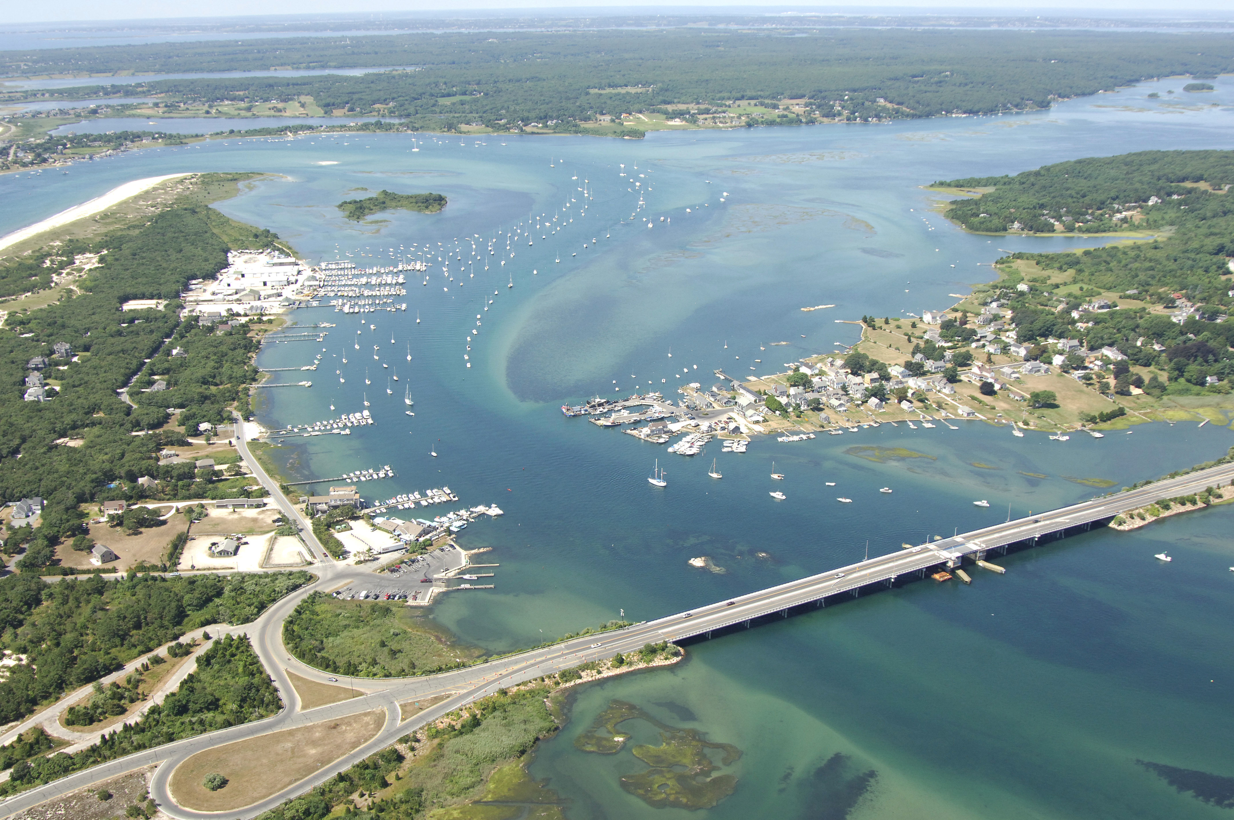
One of the first large harbors you will encounter when traveling east from Rhode Island, Westport is a large commercial fishing and recreational boating port about 13 miles east of Newport, RI, and 15 miles southwest of New Bedford. With the twisty entrance channel, Westport Harbor is protected from all but the most violent storm conditions, which makes it a popular stopover place. The harbor itself boasts 12- to 14-foot depths, and the inlet has a minimum of 10 feet, despite the strong currents and curvy nature of the channel.
Once safely inside, you will find a variety of marinas both the north and south shores of the the river, with the largest facility residing on the south shore about a mile in from the inlet. Moorings and anchorage space are scattered throughout.
Navigating the Water:
Use NOAA Chart 13218.
From Buzzards Bay, red and white Morse (A) buoy "WH" marks the beginning of the approach into Westport Harbor. From here, make sure to honor green can "1" and green daybeacon "3,"as they both mark the outer edges of Twomile Rock on the eastern side of the channel. Once you have cleared Twomile Rock, hed in to red nun "4," and then green can "5" near the Knubble.
Half Mile Rock, at the entrance to the Westport River, is marked by red nun "6." Be sure to honor it carefully. Also, green can "5" marks Dogfish Ledge to the east. Once you have cleared Half Mile Rock, flashing green "7" at The Knubble will guide you in to the first east turn in the channel, and then a series of nun buoys and a couple of lighted markers will help you the rest of the way in.
Local Notices to Mariners:
Local Notices to Mariners are available online from the U.S. Coast Guard.
Helpful Links:
Massachusetts Government Westport Site
Harbor Reviews
Summer 2022. A sandbar has formed across the channel leading into the harbor, from G"19" to R"18". Our sailboat draws 4.5 ft. and could not get out at mid-tide. Later, on a rising tide, a harbormaster boat intercepted us and led us outside the charted channel, north of G"21", G"19", and G"17" to deeper water. Go for high tide to get in and out.