


Boothbay Harbor
Boothbay, Maine United States
Marinas near Boothbay Harbor
| Name | Reviews | Max LOA | VHF | Dock Depth | Gas / Diesel | Lift / Crane | Wifi | Amps |
|---|---|---|---|---|---|---|---|---|
| Carousel Marina | 180.0' | 9 | Low 22.0' | G$4.65/galD$4.35/gal | - | 30,50 | ||
| Blake's Boat Yard | - | 0.0 m | - | Low 0.0'High 0.0' | - | - | - | - |
| Boothbay Harbor Yacht Club | 60.0' | 9 | Low 14.0' | - | - | - | ||
| Brown's Wharf Motel & Marina | 170.0' | 9 | Low 25.0' | - | - | - | ||
| Bristol Marine at The Shipyard in Boothbay Harbor | - | 16 | - | - | - | - | - | |
| Lobstermen's Cooperative, Inc. | - | - | - | - | - | - | - | - |
| Tugboat Inn | 90.0' | 9 | Low 8.0' | - | - | - | ||
| Hodgdon Marina | - | 9 | Low 16.0' | G$4.14/galD$4.14/gal | - | 30, 50, 100 | ||
| Cap'n Fish's Waterfront Inn & Marina | - | 0.0 m | 16 | Low 0.0 mHigh 0.0 m | - | - | - | - |
| Eastside Waterfront Park | - | 0.0 m | - | Low 0.0 mHigh 0.0' | - | - | - | - |
| The Lobster Dock Restaurant & Marina | - | 0.0 m | - | Low 0.0'High 0.0 m | - | - | - | - |
| Pier 6, Fisherman's Wharf | - | 0.0 m | - | Low 0.0 mHigh 0.0' | - | - | - | - |
| Boothbay Harbor Oceanside Resort Marina | 100.0' | 9 | - | - | - | 30/50/100 | ||
| Mine Oyster | - | - | - | - | - | - | - | - |
| Boothbay Harbor Marina | 130.0' | 9 | - | - | - | 30 and 50 |
Helpful Links:
Boothbay Harbor Calendar of Events
Things To Do/Local Events:
Sea kayaking, fishing, boating and water exploration by dinghy are all popular activities here. Ashore, dozens of lobster and seafood houses line the shore offering tempting simplicities such as lobster rolls served at picnic tables all the way up to full service fine dining.
Whale watching is also a fun way to spend an afternoon at sea. Whale charters depart on regular schedules during the season and all are accessible to the waterfront.
See the Helpful Links section at the bottom of this page for detailed information.
Introduction:
Boothbay Harbor is located northeast of Southport Island off Booth Bay and Boothbay Harbor. In geographical terms, Boothbay is 34 miles northeast of Portland and and about 44 miles southeast of Vinalhaven Island.
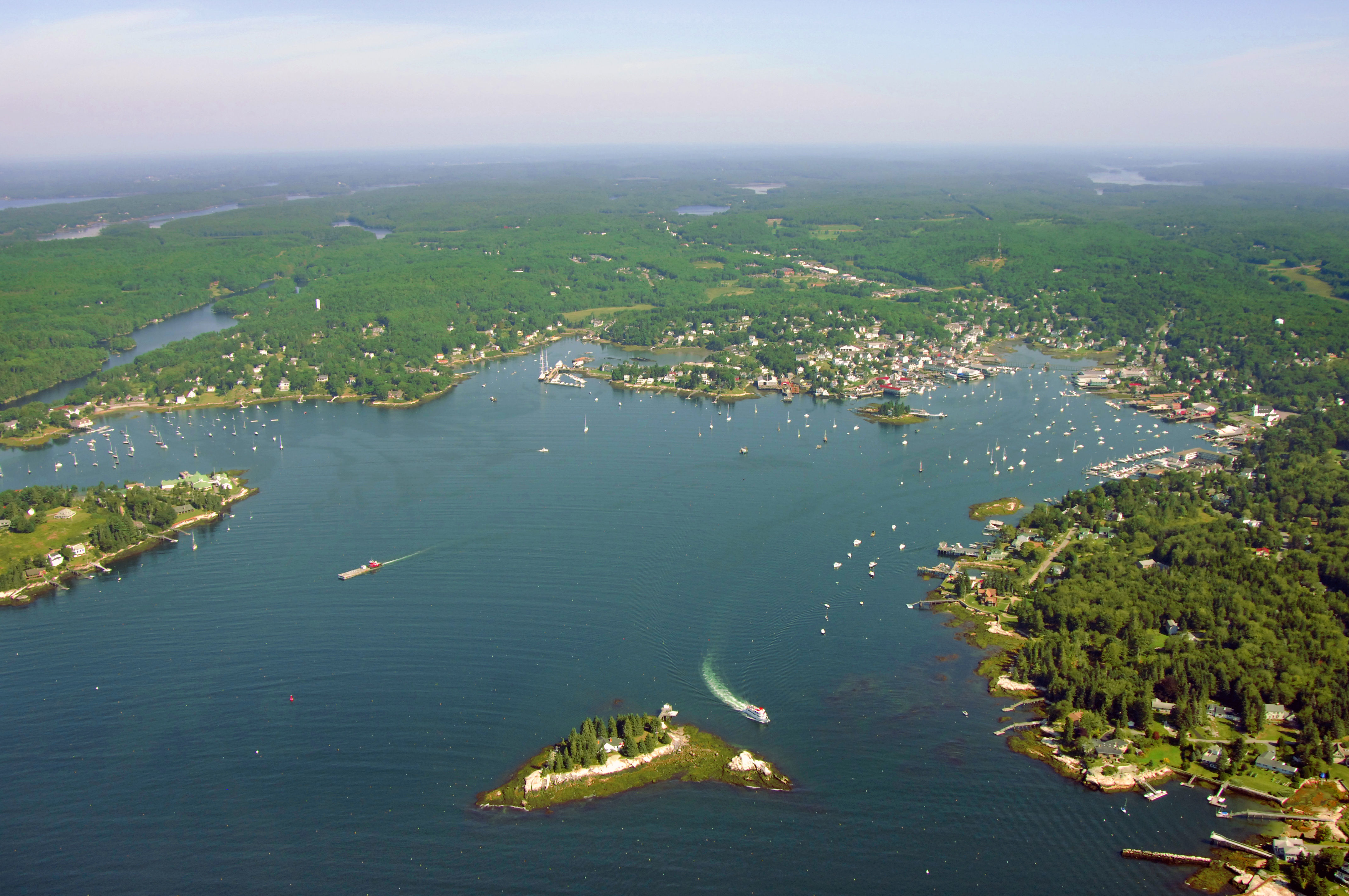
The image above is a view from the east looking west over Boothbay Harbor from a position over Linekin Bay. The long stretch of water near the hazy horizon is the Sheepscot River, while closer in you can see an excellent overview of the town of Boothbay.
There are 11 marine service and marina facilities in Boothbay, which means just about any repair, provisioning, or dockage need is at your beckon call. That said, mooring and dock space can get tight; make sure you call ahead and make arrangements before your arrival. The moorings in the harbor are maintained by the town and a few private facilities--instructions are usually on the mooring ball.
History:
English fishermen originally discovered this area of Maine, back in the 17th century. Fishing, ice cutting, shipbuilding, and lumber were the local industries in the 18th and 19th century. By the 1800s visitors started coming to the area. Since then, Boothbay has become the largest boating harbor north of Boston.
Navigating the Water:
Use NOAA Chart 13293.
Boothbay Harbor is reached via an approach from the south through Booth Bay, a close by, but differently spelled body of water than its cousin to the north.
The passage from the Atlantic Ocean through Booth Bay starts near a large grouping of rocky islands known as The Cuckolds. The Cuckolds are located at the southern end of Southport Island, and are marked with Cuckold Lighthouse (59 feet above water; flashing white every six seconds; horn)--an excellent aid to mariners approaching from offshore at night or during fog.
The specific aid to navigation you are shooting for is green can (bell) buoy 1C, which is located near the following position: N43 46.382 W69 39.003. Once you have safely navigated to green can 1C, set and follow a new approximate course of 034 degrees magnetic for about 2.3 miles to intercept red daybeacon 2 at the southwest end of Squirrel Island.
Leave red daybeacon 2 well to starboard as you pass it, and then set a new course to the north--making sure to stay clear of Squirrel Island's western point--to pick up flashing red buoy 4 off the northwest end of Squirrel Island.
From flashing red buoy 4, point your boat to a heading of about 043 degrees magnetic, and then follow this course for about nine-tenths of a mile to reach red nun buoy 6, which is west of Spruce Point.
You might feel like you are playing connect the dots at this point, but there are only two more markers left. Once you have cleared previously mentioned red nun buoy 6, head toward the northwest to intercept flashing red buoy 8, which is located northwest o Turner Island--a geographical hazard you will need to stay clear of.
Youre almost there. Past flashing red buoy 8, set your final approach course of about 052 degrees magnetic and follow it for approximately seven-tenths of a mile where you will find flashing green buoy 9 at the base of Boothbay Harbor.
Local Notices to Mariners:
Local Notices to Mariners are available online from the U.S. Coast Guard.
Transportation:
A couple of local cab companies offer local transportation or may travel to farther destinations with advance notice.
The closest airport is Knox County Regional Airport, some 30 miles to the northeast near Rockland.